1970s Maps of Luce County, Michigan
Explore 14 historic maps of Luce County from the 1970s. These maps offer a rare glimpse into what life looked like during the 1970s — showing old roads, neighborhoods, homes, and landmarks that have changed or disappeared over time.
Whether you're researching your family's past, planning a metal detecting trip, or studying how Luce County's landscape evolved across the 1970s, these high-resolution maps are a powerful tool for exploring the history of this region.
- Focus on a specific era: All maps on this page are from the 1970s, giving you a focused view of this time period.
- See what’s changed: Compare century-old streets, trails, and buildings to today's modern landscape using overlays and satellite layers.
- Research with precision: Use these maps for genealogy, historical research, land use analysis, or educational projects.
- View, download, or print: Maps are fully viewable online in high resolution, and can be downloaded or printed for your own records.
Start exploring Luce County's history through authentic maps from the 1970s. This is your window into the past.
Luce County, MI maps
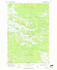
(14)- 1972 Map of Hardwood Island, 1975 Print
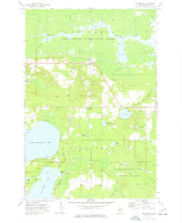
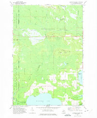 1972 Hardwood Island1975 Print · USGSLuce and Schoolcraft counties are shown in the early 1970s, a landscape defined by the vast northern forests and the clear shores of the Manistique lakes. Genealogists and historians can locate the West Lakefield Cem, the Soo Line rail stops at Danaher, and the landings along North Manistique Lake.2 unique versions available
 - 1972 Map of Tahquamenon Lakes, 1975 Print
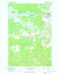
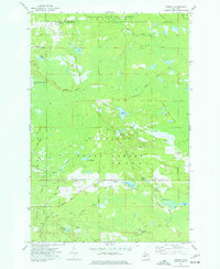
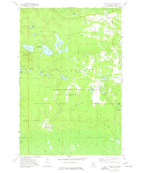
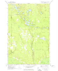 1972 Tahquamenon Lakes1975 Print · USGSLuce County’s lake country is captured here in the early 1970s, showing a vast network of timber roads and forest lands. Researchers can trace the layout of the Laketon settlement and find numerous small water bodies like Camp 7 Lake and Fur Farm Lake.
 - 1972 Map of Curtis West, 1975 Print
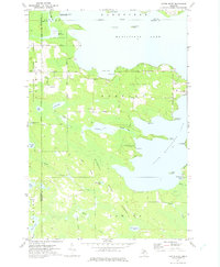 1972 Curtis West1975 Print · USGSMackinac County's lakeland region comes into focus during the early seventies, showing the gateway between the Manistique Lakes. Genealogists and historians can trace the Old Railroad Grade, find the Sandpit Cem, and explore the settlement of Curtis.
 - 1973 Map of Curtis East, 1977 Print
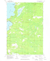 1973 Curtis East1977 Print · USGSUpper Peninsula timberlands and lakefronts meet in the 1970s as the town of Curtis sits between two major lakes. Genealogists and historians can trace the Old Railroad Grade or locate the Sandtown Cemetery and Wildwood Church.
 - 1973 Map of McMillan, 1977 Print
 1973 McMillan1977 Print · USGSUpper Peninsula timber and lakeside life intersect in the 1970s as the railroad connects small settlements like McMillan and Laketon. Researchers can trace local heritage through the Lakefield Ch and multiple burial sites like the Old East Lakefield Cem.
 - 1973 Map of Newberry, 1977 Print
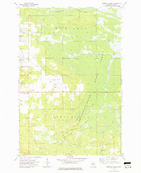
 1973 Newberry1977 Print · USGSNewberry and its neighboring timber settlements are captured in the mid-seventies, showing the village alongside the extensive Tahquamenon River State Forest. Researchers can trace the Old Railroad Grade and locate local landmarks like the Newberry State Hosp and Pentland Sch.
 - 1973 Map of Gilchrist, 1977 Print
 1973 Gilchrist1977 Print · USGSMackinac County forestry and rail operations define this landscape in the early seventies, centered on the settlement of Gilchrist. Trace old logging infrastructure through the Old RR Grade and find water features like the Cranberry Lake Bog and Lucky Lake.
 - 1973 Map of Millecoquins, 1977 Print
 1973 Millecoquins1977 Print · USGSMackinac County's forested lake country is documented here during the early seventies, showing the intersection of timber management and rural settlement. Researchers can locate the Bethlehem Ch, the Soo Line tracks, and family-named landmarks like McAlpine Pond and Kelvey.
 - 1973 Map of Garnet, 1977 Print
 1973 Garnet1977 Print · USGSMackinac County's timber and rail history is preserved in this mid-century survey of the Mackinac State Forest and the village of Garnet. Researchers can trace old transportation corridors like the Old RR Grade and find local landmarks such as Maplewood Cem and the Garnet Lake Campground.
 - 1973 Map of Roberts Corner, 1977 Print
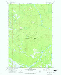
 1973 Roberts Corner1977 Print · USGSUpper Peninsula life in the 1970s centered on the junction of rail and river near Newberry. Genealogists and historians can trace the grounds of the Newberry State Hospital, the rural outpost at Roberts Corner, and the path of the Soo Line through the State Forest.
 - 1973 Map of Gimlet Creek, 1977 Print
 1973 Gimlet Creek1977 Print · USGSUpper Peninsula wilderness in the early 1970s is defined by the winding Tahquamenon River and its many tributaries. Genealogists and researchers can trace former industrial routes like the Old RR Grade and find remote spots like Betty B Landing.
 - 1973 Map of Soo Junction, 1977 Print
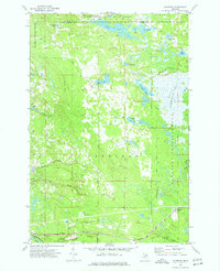
 1973 Soo Junction1977 Print · USGSLuce County's logging and rail history is etched into this map of the Upper Peninsula during the early seventies. Researchers can trace the path of the Soo Line Railroad through Soo Junction or follow timber routes like the Old Railroad Grade and Sage Truck Trail.
 - 1973 Map of Roy Lake, 1977 Print
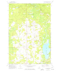
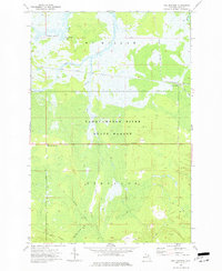
 1973 Roy Lake1977 Print · USGSLuce County's forested interior is captured here in the 1970s, showcasing the transition from industrial timber lands to state-managed forest. Researchers can trace historic transport routes like the Charcoal Grade and Railroad Grade near Roy Lake and the Tahquamenon River.
 - 1973 Map of Buckeye Lake, 1977 Print
 1973 Buckeye Lake1977 Print · USGSLuce County's lake country in the early 1970s is shown here as a landscape of state-managed forest and remote timber tracks. Outdoor enthusiasts and local historians can locate the Beech Hill Lookout Tower and trace old logging routes like Camp One Road or Camp Six Road past dozens of named ponds.
End of results
Showing maps 1-14 of 14
Frequently asked questions
- What are the different types of historical maps available for Luce County?
- What is the oldest map of Luce County?
- Where can I purchase historical maps of Luce County for my home or office?
- Where can I download high-res historical maps of Luce County?
- Are there historical topographic maps available for Luce County?
- Is there historical aerial imagery available for Luce County?
- Where are historical maps of Luce County sourced from?