1960s Maps of Moran Township, Michigan
Explore 10 historic maps of Moran Township from the 1960s. These maps offer a rare glimpse into what life looked like during the 1960s — showing old roads, neighborhoods, homes, and landmarks that have changed or disappeared over time.
Whether you're researching your family's past, planning a metal detecting trip, or studying how Moran Township's landscape evolved across the 1960s, these high-resolution maps are a powerful tool for exploring the history of this region.
- Focus on a specific era: All maps on this page are from the 1960s, giving you a focused view of this time period.
- See what’s changed: Compare century-old streets, trails, and buildings to today's modern landscape using overlays and satellite layers.
- Research with precision: Use these maps for genealogy, historical research, land use analysis, or educational projects.
- View, download, or print: Maps are fully viewable online in high resolution, and can be downloaded or printed for your own records.
Start exploring Moran Township's history through authentic maps from the 1960s. This is your window into the past.
Moran Township, MI maps
(10)- 1964 Map of Ozark, 1965 Print
 1964 Ozark1965 Print · USGSThe Upper Peninsula wilderness of Chippewa and Mackinac Counties is captured here in the mid-1960s as a landscape of timber and rail. Genealogists and local historians can locate the community of Ozark, the Brethren Cem, and landmarks like the Trout Lake Lookout Tower.3 unique versions available
 - 1964 Map of Big Stone Bay, 1965 Print
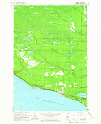
 1964 Big Stone Bay1965 Print · USGSThe northern tip of Emmet County is shown in the mid-1960s, where the protected lands of Wilderness State Park meet the lake. Researchers can trace the shoreline from Waugoshance Point up to the isolated St Helena Island.2 unique versions available
 - 1964 Map of Brevort, 1965 Print
 1964 Brevort1965 Print · USGSThe Mackinac coast of the Upper Peninsula comes into focus during the mid-1960s, showing the intersection of Great Lakes shoreline and managed forest. Researchers can trace the layout of the Brevort settlement, the Brevort Cem, and recreational sites like the Little Brevoort Lake Campground.2 unique versions available
 - 1964 Map of Moran, 1966 Print
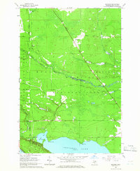
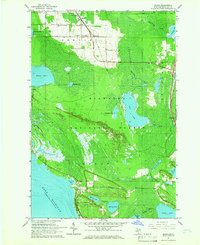 1964 Moran1966 Print · USGSUpper Peninsula timber and rail life come into focus in the mid-1960s near the Straits. Genealogists and local historians can locate early landmarks like Zion Ch, the Brevoort Cem, and the rail stops at Moran and Allenville.2 unique versions available
 - 1964 Map of Pointe Aux Chenes, 1966 Print
 1964 Pointe Aux Chenes1966 Print · USGSMackinac County's shoreline in the mid-sixties reveals a landscape of protected forests and complex coastal wetlands. Researchers can trace the winding Pointe Aux Chenes River through the Pointe Aux Chenes Marshes and locate the historic Lake Michigan Campground.2 unique versions available
 - 1964 Map of Evergreen Shores, 1966 Print
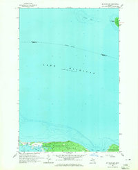
 1964 Evergreen Shores1966 Print · USGSThe Straits of Mackinac area in the mid-1960s shows a landscape of north-woods forests and expanding coastal settlements. Researchers can trace family sites near Evergreen Shores, locate historic British Landing on Mackinac Island, and identify landmarks like Castle Rock.2 unique versions available
 - 1964 Map of St. Ignace, 1966 Print
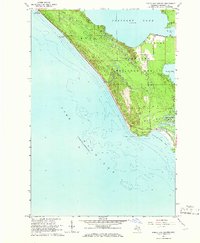
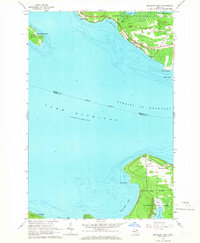
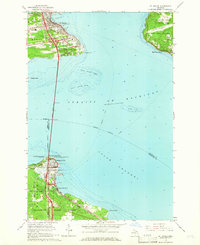 1964 St. Ignace1966 Print · USGSThe Straits of Mackinac were in a period of transition in the mid-sixties, linked by the recently completed Mackinac Bridge. Genealogists and historians can trace the rail terminals of the Pennsylvania and waterfront sites like Old Mackinac Point and Edgewater Beach.2 unique versions available
 - 1964 Map of Trout Lake, 1966 Print
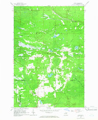
 1964 Trout Lake1966 Print · USGSTrout Lake emerged as a vital Upper Peninsula rail hub in the mid-twentieth century, surrounded by the deep woods of the Hiawatha and Mackinac State Forests. Researchers can trace the original Soo Line rail corridors, the historic Lakeview Cem, and local landmarks like School No 15.2 unique versions available
 - 1964 Map of McGulpin Point, 1966 Print
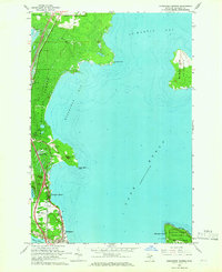
 1964 McGulpin Point1966 Print · USGSThe tip of Michigan's Lower Peninsula and the Upper Peninsula shore meet at the straits in the mid-1960s. Researchers can trace the layout of Mackinaw City, locate Gros Cap Cem, or study the shoreline around Mc Gulpin Point.2 unique versions available
 - 1964 Map of Kenneth, 1966 Print
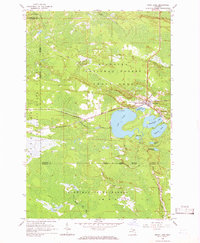
 1964 Kenneth1966 Print · USGSThe Hiawatha National Forest meets the northern shores of Brevoort Lake in the mid-1960s. Trace the Soo Line railroad through the woods past Kenneth or find local landmarks like Rock Rapids and the Boedne Bay Campground.2 unique versions available
End of results
Showing maps 1-10 of 10
Top cities near Moran Township
- Saint Ignace historical maps
- Moran historical maps
- Mackinaw City historical maps
- Brevort historical maps
- Trout Lake historical maps
Top neighborhoods of Moran Township
Frequently asked questions
- What are the different types of historical maps available for Moran Township?
- What is the oldest map of Moran Township?
- Where can I purchase historical maps of Moran Township for my home or office?
- Where can I download high-res historical maps of Moran Township?
- Are there historical topographic maps available for Moran Township?
- Is there historical aerial imagery available for Moran Township?
- Where are historical maps of Moran Township sourced from?