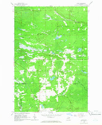
1964 Map of Ozark
USGS Topo · Published 1965About this map
The timberlands and wetlands of the Upper Peninsula define this area in the mid-1960s, where the Soo Line railroad cuts a straight path through the Hiawatha National Forest. The settlement of Ozark serves as a focal point for local history, situated near the boundary between Chippewa and Mackinac Counties. The landscape is a complex network of water and forest, featuring numerous named ponds and creeks such as Bobbygay Lake, Boaz Lake, and the winding North Branch Carp River.
Find a feature on this map
32 named features on this map. Tap any name to fly to it.
Don’t see what you’re looking for? This feature index may not catch every label — zoom into the map to look around manually.
Map Details
Editions of this 1964 Ozark Map
3 editions found
Other maps of this area

1931 · Epoufette SE
USGS Topo · 1:31,680

1931 · Epoufette NE
USGS Topo · 1:31,680

1931 · Ozark SE
USGS Topo · 1:31,680

1941 · Strongs
USGS Topo · 1:63,360

1951 · Strongs
USGS Topo · 1:24,000

1951 · Sullivan Creek
USGS Topo · 1:24,000

1951 · Eckerman
USGS Topo · 1:24,000

1951 · Strongs
USGS Topo · 1:62,500

1951 · Eckerman
USGS Topo · 1:62,500

1954 · Sault Sainte Marie
USGS Topo · 1:250,000