1900-1909 Maps of Warren, Michigan
Explore 3 historic maps of Warren from 1900-1909. These maps offer a rare glimpse into what life looked like during the 1900s — showing old roads, neighborhoods, homes, and landmarks that have changed or disappeared over time.
Whether you're researching your family's past, planning a metal detecting trip, or studying how Warren's landscape evolved across the 1900s, these high-resolution maps are a powerful tool for exploring the history of this region.
- Focus on a specific era: All maps on this page are from the 1900s, giving you a focused view of this time period.
- See what’s changed: Compare century-old streets, trails, and buildings to today's modern landscape using overlays and satellite layers.
- Research with precision: Use these maps for genealogy, historical research, land use analysis, or educational projects.
- View, download, or print: Maps are fully viewable online in high resolution, and can be downloaded or printed for your own records.
Start exploring Warren's history through authentic maps from the 1900s. This is your window into the past.
Warren, MI maps
(3)- 1905 Map of Detroit
 1905 Detroit1905 Print · USGSDetroit and its surrounding townships are shown at a pivotal moment of expansion during the early 1900s. Genealogists and historians can trace the development of early suburbs like Highland Park and Royal Oak along major transit arteries like Grand River Ave. and the numerous electric railways.2 unique versions available
 - 1905 Map of Grosse Pointe
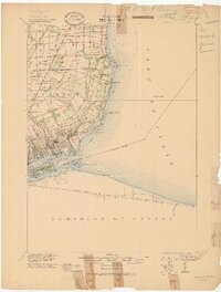 1905 Grosse Pointe1905 Print · USGSCoastal Wayne County at the turn of the century shows an era of transit-driven growth along Lake St Clair. Researchers can trace the early layout of Grosse Pointe Shores, the grounds of Belle Isle Park, and the route of the Grand Trunk R R.4 unique versions available
 - 1908 Map of Rochester
 1908 Rochester1908 Print · USGSSoutheast Michigan at the turn of the century shows a bustling landscape of early electric railways and rural township life. Genealogists and local historians can trace the foundations of Rochester, Birmingham, and Utica, alongside vanished landmarks like Snell School and the Stone Shop.3 unique versions available
End of results
Showing maps 1-3 of 3
Top cities near Warren
- Detroit historical maps
- Sterling Heights historical maps
- Clinton Township historical maps
- Dearborn historical maps
- Macomb Township historical maps
- Troy historical maps
See more
Top neighborhoods of Warren
Frequently asked questions
- What are the different types of historical maps available for Warren?
- What is the oldest map of Warren?
- Where can I purchase historical maps of Warren for my home or office?
- Where can I download high-res historical maps of Warren?
- Are there historical topographic maps available for Warren?
- Is there historical aerial imagery available for Warren?
- Where are historical maps of Warren sourced from?