1900s (20th Century) Maps of Warren, Michigan
Explore 33 historic maps of Warren from the 1900s (20th Century). These maps offer a rare glimpse into what life looked like during the 1900s — showing old roads, neighborhoods, homes, and landmarks that have changed or disappeared over time.
Whether you're researching your family's past, planning a metal detecting trip, or studying how Warren's landscape evolved across the 1900s, these high-resolution maps are a powerful tool for exploring the history of this region.
- Focus on a specific era: All maps on this page are from the 1900s, giving you a focused view of this time period.
- See what’s changed: Compare century-old streets, trails, and buildings to today's modern landscape using overlays and satellite layers.
- Research with precision: Use these maps for genealogy, historical research, land use analysis, or educational projects.
- View, download, or print: Maps are fully viewable online in high resolution, and can be downloaded or printed for your own records.
Start exploring Warren's history through authentic maps from the 1900s. This is your window into the past.
Warren, MI maps
(33)- 1905 Map of Detroit
 1905 Detroit1905 Print · USGSDetroit and its surrounding townships are shown at a pivotal moment of expansion during the early 1900s. Genealogists and historians can trace the development of early suburbs like Highland Park and Royal Oak along major transit arteries like Grand River Ave. and the numerous electric railways.2 unique versions available
 - 1905 Map of Grosse Pointe
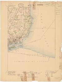 1905 Grosse Pointe1905 Print · USGSCoastal Wayne County at the turn of the century shows an era of transit-driven growth along Lake St Clair. Researchers can trace the early layout of Grosse Pointe Shores, the grounds of Belle Isle Park, and the route of the Grand Trunk R R.4 unique versions available
 - 1908 Map of Rochester
 1908 Rochester1908 Print · USGSSoutheast Michigan at the turn of the century shows a bustling landscape of early electric railways and rural township life. Genealogists and local historians can trace the foundations of Rochester, Birmingham, and Utica, alongside vanished landmarks like Snell School and the Stone Shop.3 unique versions available
 - 1912 Map of Mt Clemens
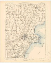
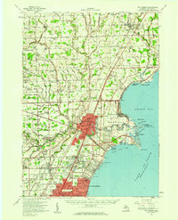
 1912 Mt Clemens1912 Print · USGSMacomb County at the dawn of the aviation age shows a landscape shaped by the winding Clinton River and the arrival of Selfridge Aviation Field. Genealogists and historians can locate legacy settlements like Waldenburg and early industrial sites like the Macomb Sugar Factory.
 - 1918 Map of Detroit
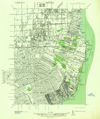
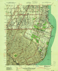
 1918 Detroit1918 Print · USGSDetroit and its surrounding townships appear at the height of the early industrial era, captured just after the close of the Great War. Local researchers can trace the growth of the Ford Motor Co. empire near Navarre P.O. and explore the historic rail corridors of Hamtramck and Royal Oak.
 - 1918 Map of Grosse Pointe
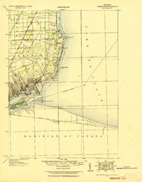 1918 Grosse Pointe1918 Print · USGSThe Lake St. Clair shoreline comes alive in this late-era survey of Wayne and Macomb counties, showing the region just as the Grosse Pointes were formalizing. Trace early electric transit via the Detroit and Port Huron Electric Line and locate vanished stops at Labadies or Claireview.
 - 1924 Map of Detroit
 1924 Detroit1924 Print · USGSDetroit and its industrial satellites thrive during the peak of the automotive era. Genealogists and historians can trace the early factory footprints of Dodge Bros. or locate old neighborhood landmarks like Navarre P. O. and Mt. Olivet Cemetery.
 - 1929 Map of Mt Clemens
 1929 Mt Clemens1929 Print · USGSMacomb County at the end of the twenties shows a landscape of growing towns and early aviation history along the Lake Saint Clair shoreline. Genealogists and historians can trace local landmarks like Selfridge Field, the Grand Trunk Railroad, and numerous parish schools from Fraser to New Haven.4 unique versions available
 - 1934 Map of Detroit
 1934 Detroit1934 Print · USGSThe Detroit riverfront and its rising industrial suburbs are captured here during the peak of the automotive boom. Genealogists and historians can trace the early footprints of the Ford Motor Co and local landmarks like Olivet Cemetery or the State Fair Grounds.
 - 1936 Map of Warren
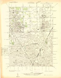
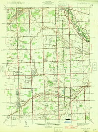
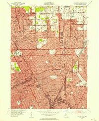
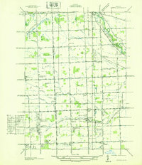 1936 Warren1936 Print · USGSThe Macomb and Oakland county line in the mid-1930s shows a landscape of small townships and early subdivisions. Genealogists can trace family roots through numerous local schools like Berz Sch or find historic burials at Warren Cem and Memorial Park Cem.
 - 1936 Map of Highland Park
 1936 Highland Park1936 Print · USGSGreater Detroit and the enclaves of Highland Park and Hamtramck are captured here in the mid-1930s as urban growth pushes north. Researchers can pinpoint early neighborhoods, local schools like Henry Ford Sch, and the grounds of the Michigan State Fair.
 - 1936 Map of Grosse Pointe
 1936 Grosse Pointe1936 Print · USGSThe Detroit lakeshore and its rising suburbs are captured here in the mid-1930s, showing a landscape of yacht clubs, golf courses, and dense street grids. Trace the growth of Grosse Pointe Shores and Roseville or locate landmarks like Jefferson Beach and the Erin Cem.
 - 1936 Map of Mt Clemens
 1936 Mt Clemens1936 Print · USGSMacomb County is captured here in the mid-1930s, showing the early suburban development radiating from Mt Clemens along the Clinton River. Researchers can trace old family burial grounds like Sterling Grove Cem and local schoolhouses including Nicke Sch and Garfield Sch.
 - 1940 Map of Highland Park
 1940 Highland Park1940 Print · USGSGreater Detroit was expanding rapidly just before the war, as residential grids replaced the agricultural lands of southern Macomb and Oakland Counties. Genealogists and historians can locate family landmarks like the Michigan State Fair Grounds and St Clements Cem.2 unique versions available
 - 1940 Map of Grosse Pointe
 1940 Grosse Pointe1940 Print · USGSCoastal Wayne County and the rising Detroit suburbs are captured here just before the war. Researchers can trace the development of the Pointes and find family landmarks like St Peters Ch, Jefferson Beach, and Gratiot Airport.
 - 1946 Map of Warren
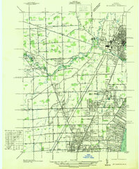
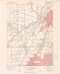
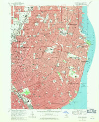
 1946 Warren1946 Print · USGSThe Macomb and Oakland county borderlands are shown here in the mid-1940s, capturing a world of rural schools and early suburban aviation. Genealogists can trace family footprints near the Warren Cem, Big Beaver, and rural schoolhouses like Burr Sch.
 - 1952 Map of Mt Clemens West, 1953 Print
 1952 Mt Clemens West1953 Print · USGSMacomb County was undergoing rapid postwar development in the early fifties as suburbs pushed north from Detroit. Genealogists and historians can trace the foundations of Fraser, Broad Acres, and St Clair Shores alongside landmarks like Joy Airport and the Grand Trunk Railway.2 unique versions available
 - 1952 Map of Warren, 1953 Print
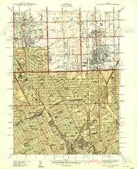
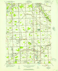 1952 Warren1953 Print · USGSSoutheastern Michigan at the dawn of the 1950s reveals a patchwork of established farms and emerging suburbs along the county line. Genealogists can trace family footprints at Warren Cem and find early schoolhouses like Colerain Sch or Burr Sch.2 unique versions available
 - 1952 Map of Grosse Pointe, 1953 Print
 1952 Grosse Pointe1953 Print · USGSThe Lake St. Clair shoreline and Detroit's northeast suburbs are captured here during the post-war population boom. Researchers can trace mid-century neighborhood growth and find dozens of local landmarks like the Grosse Pointe Yacht Club and Assumption Sch & Cem.2 unique versions available
 - 1952 Map of Highland Park, 1954 Print
 1952 Highland Park1954 Print · USGSMid-century Detroit and its northern enclave cities show a bustling urban landscape at the height of the industrial era. Trace neighborhood roots across Highland Park and Hamtramck using landmarks like Evergreen Cemetery and the City Airport.2 unique versions available
 - 1952 Map of Mt Clemens, 1959 Print
 1952 Mt Clemens1959 Print · USGSIn the early fifties, Macomb County saw rapid suburban growth around the massive Selfridge Air Force Base and Lake St. Clair. Genealogists can trace early neighborhood roots and family landmarks like McKinley Airport, Moravian Sch, and St Paul Cem.
 - 1954 Map of Detroit
 1954 Detroit1954 Print · USGSThe Detroit metro and its Ontario neighbors are shown at the height of the mid-century industrial era, just as the suburbs were rapidly expanding. Researchers can trace the massive rail networks of the Wabash Railroad or locate landmarks like Grosse Ile and Selfridge Air Force Base.
 - 1961 Map of Detroit, 1973 Print
 1961 Detroit1973 Print · USGSThe international border between Michigan and Ontario was a bustling industrial corridor in the early sixties. Researchers can trace the transit networks and riverfront infrastructure connecting Detroit to Windsor via the Detroit-Windsor Tunnel and major air hubs like Willow Run Airport.2 unique versions available
 - 1965 Map of Detroit
 1965 Detroit1965 Print · USGSThe industrial corridor between Michigan and Ontario is captured here at mid-century, showing the dense rail and river networks of the Great Lakes. Local historians can trace the paths of the Grand Trunk Western RR and locate key landmarks like Selfridge Air Force Base and Grosse Ile.
 - 1968 Map of Grosse Pointe, 1971 Print
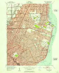
 1968 Grosse Pointe1971 Print · USGSThe Grosse Pointe shoreline and Detroit's eastern neighborhoods are shown here in the late sixties, just as modern shopping centers and residential grids were fully established. Genealogists and local historians can locate early burial sites like Mt Calvary Sch Cem and landmarks such as the Grosse Pointe Yacht Club and Chandler Park.4 unique versions available
Showing maps 1-25 of 33
Top cities near Warren
- Detroit historical maps
- Sterling Heights historical maps
- Clinton Township historical maps
- Dearborn historical maps
- Macomb Township historical maps
- Troy historical maps
See more
Top neighborhoods of Warren
Frequently asked questions
- What are the different types of historical maps available for Warren?
- What is the oldest map of Warren?
- Where can I purchase historical maps of Warren for my home or office?
- Where can I download high-res historical maps of Warren?
- Are there historical topographic maps available for Warren?
- Is there historical aerial imagery available for Warren?
- Where are historical maps of Warren sourced from?