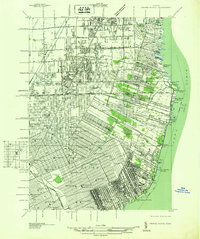
1936 Map of Grosse Pointe
USGS Topo · Published 1936About this map
Lake St Clair defines the eastern edge of this 1936 survey, which documents the rapid residential and recreational expansion of the Detroit area. The landscape is a transition from the dense street grids of Detroit to the emerging suburbs of Grosse Pointe Farms and Lochmoor. One can see the social and infrastructure pillars of the era, from the Grosse Pointe Yacht Club on the shore to the Gratiot Airport inland. Educational development is highly visible, with dozens of institutions like the Detroit University Sch and Southeastern High Sch serving the growing population. The presence of the Grand Trunk Western RR and the Erin Cem provides a look at the industrial and communal history of East Detroit and Roseville before the full arrival of the interstate era.
Find a feature on this map
90 named features on this map. Tap any name to fly to it.
Don’t see what you’re looking for? This feature index may not catch every label — zoom into the map to look around manually.
Map Details
Editions of this 1936 Grosse Pointe Map
This is the sole edition of this map. No revisions or reprints were ever made.
Other maps of this area

1905 · Detroit
USGS Topo · 1:62,500

1905 · Grosse Pointe
USGS Topo · 1:62,500

1908 · Rochester
USGS Topo · 1:62,500

1912 · Mt Clemens
USGS Topo · 1:62,500

1918 · Detroit
USGS Topo · 1:62,500

1918 · Grosse Pointe
USGS Topo · 1:62,500

1924 · Detroit
USGS Topo · 1:62,500

1929 · Mt Clemens
USGS Topo · 1:62,500

1934 · Detroit
USGS Topo · 1:62,500

1936 · Warren
USGS Topo · 1:31,680