1940s Maps of Warren, Michigan
Explore 3 historic maps of Warren from the 1940s. These maps offer a rare glimpse into what life looked like during the 1940s — showing old roads, neighborhoods, homes, and landmarks that have changed or disappeared over time.
Whether you're researching your family's past, planning a metal detecting trip, or studying how Warren's landscape evolved across the 1940s, these high-resolution maps are a powerful tool for exploring the history of this region.
- Focus on a specific era: All maps on this page are from the 1940s, giving you a focused view of this time period.
- See what’s changed: Compare century-old streets, trails, and buildings to today's modern landscape using overlays and satellite layers.
- Research with precision: Use these maps for genealogy, historical research, land use analysis, or educational projects.
- View, download, or print: Maps are fully viewable online in high resolution, and can be downloaded or printed for your own records.
Start exploring Warren's history through authentic maps from the 1940s. This is your window into the past.
Warren, MI maps
(3)- 1940 Map of Highland Park
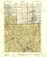 1940 Highland Park1940 Print · USGSGreater Detroit was expanding rapidly just before the war, as residential grids replaced the agricultural lands of southern Macomb and Oakland Counties. Genealogists and historians can locate family landmarks like the Michigan State Fair Grounds and St Clements Cem.2 unique versions available
 - 1940 Map of Grosse Pointe
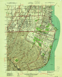 1940 Grosse Pointe1940 Print · USGSCoastal Wayne County and the rising Detroit suburbs are captured here just before the war. Researchers can trace the development of the Pointes and find family landmarks like St Peters Ch, Jefferson Beach, and Gratiot Airport.
 - 1946 Map of Warren
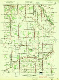 1946 Warren1946 Print · USGSThe Macomb and Oakland county borderlands are shown here in the mid-1940s, capturing a world of rural schools and early suburban aviation. Genealogists can trace family footprints near the Warren Cem, Big Beaver, and rural schoolhouses like Burr Sch.
End of results
Showing maps 1-3 of 3
Top cities near Warren
- Detroit historical maps
- Sterling Heights historical maps
- Clinton Township historical maps
- Dearborn historical maps
- Macomb Township historical maps
- Troy historical maps
See more
Top neighborhoods of Warren
Frequently asked questions
- What are the different types of historical maps available for Warren?
- What is the oldest map of Warren?
- Where can I purchase historical maps of Warren for my home or office?
- Where can I download high-res historical maps of Warren?
- Are there historical topographic maps available for Warren?
- Is there historical aerial imagery available for Warren?
- Where are historical maps of Warren sourced from?