Old Maps of Marquette County, Michigan for Academic Research
Study the evolution of Marquette County with 408 high-resolution historic maps. Whether you're teaching, researching, or modeling changes in land use, these maps provide essential visual documentation of urban, environmental, and geographic change.
- Analyze long-term change: Track patterns in development, transportation, and natural features.
- Ideal for environmental or urban studies: Support academic projects with primary historical map data.
- Use in the classroom or lab: Educators and researchers rely on these maps to bring historical context to life.
These maps are a powerful tool for teaching, research, and visualizing how Marquette County has changed over the decades.
Marquette County, MI maps
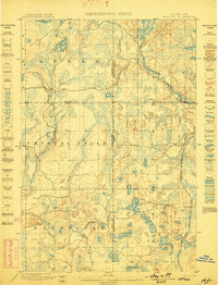
(408)- 1899 Map of Sagola
 1899 Sagola1899 Print · USGSIron and Dickinson counties were defined by the expansion of the rail-and-river economy in the late nineteenth century. Genealogists and historians can trace the early layouts of Channing, Sagola, and Mansfield alongside the winding Michigamme River.3 unique versions available
 - 1899 Map of Witbeck
 1899 Witbeck1899 Print · USGSThe Upper Peninsula’s rugged timber and rail corridor comes to life in this survey conducted during the 1890s. Researchers can trace the dual rail lines serving Witbeck or locate early wilderness landmarks like Fence Lake, Witch Lake, and the winding Michigamme River.3 unique versions available
 - 1907 Map of Marquette
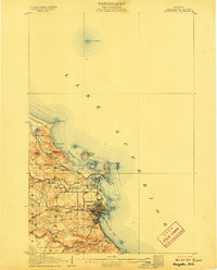 1907 Marquette1907 Print · USGSMarquette and its Lake Superior shoreline appear here during a period of heavy industrial growth in the early twentieth century. Researchers can trace the complex rail networks of the Marquette and Southeastern and locate landmarks like the State Prison and Powder Works.3 unique versions available
 - 1932 Map of Skandia SW
 1932 Skandia SW1932 Print · USGSMarquette County's timberlands and rail stops are captured here in the early 1930s. Trace old logging-era sites like Wendt and Bartles Camp and rural schools like Carlshend Sch along the Lake Superior and Ishpeming railroad.
 - 1932 Map of Rock SW
 1932 Rock SW1932 Print · USGSUpper Peninsula timber and transit define this 1930s landscape near the Marquette and Delta county line. You can trace the rural school system from North Finn Sch down to St Nicholas Sch or locate family plots at ROCK CEM near the village of Rock.
 - 1932 Map of Helena NW
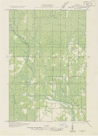
 1932 Helena NW1932 Print · USGSMarquette County's timber and mining lands are shown here in the early 1930s, punctuated by remote industrial outposts and expansive wetlands. You can locate old logging sites like Victor Larson Camp and the Gardner Mine along the Escanaba River corridor.
 - 1932 Map of Helena NE
 1932 Helena NE1932 Print · USGSMarquette County's logging and rail infrastructure are on full display in the early 1930s before modern development altered the Upper Peninsula. Genealogists and historians can trace numerous remote outposts like Rochenon Camp, Anderson Camp, and the settlement of Helena.
 - 1932 Map of Rock NE
 1932 Rock NE1932 Print · USGSThe timber-heavy border between Alger and Delta Counties comes to life in the early thirties. Trace the legacy of old logging camps and homesteads like Suomi Camp, Gould Homestead, and the Osier Sch along the Chicago and Northwestern rail line.
 - 1932 Map of Skandia SE
 1932 Skandia SE1932 Print · USGSIn the early 1930s, this pocket of the Upper Peninsula was a landscape of managed forests and timber-connected outposts. Genealogists can locate family sites near Dorsey Sch, the community of Sundell, and the remote Fancetts Camp along the river.
 - 1932 Map of Whitney NE
 1932 Whitney NE1932 Print · USGSThe Upper Peninsula interior during the early 1930s was a landscape of timber-hauling railroads and remote hydro projects. Researchers can locate small communities like Woodlawn and Hendricks or trace the schools and dams along the Escanaba River.
 - 1932 Map of Harvey NW
 1932 Harvey NW1932 Print · USGSMarquette County's central interior is captured in the early 1930s just as aerial surveying began to transform mapping. Genealogists can locate family-named landmarks and civic hubs like Sands PO, Sands Sch Nº 2, and the settlement at Cascade.
 - 1932 Map of Skandia NE
 1932 Skandia NE1932 Print · USGSThe Upper Peninsula coastline near the border of Marquette and Alger counties is captured here in the early 1930s. Trace the path of the Duluth South Shore and Atlantic railroad as it parallels the Sand River and Lake Superior shoreline.
 - 1932 Map of Harvey SE
 1932 Harvey SE1932 Print · USGSMarquette County's timber and rail landscape is captured here in the early thirties as development centered on the Little Lake Forsyth PO rail junction. Genealogists can locate family landmarks like the Racine Sch, West Br Cem, and several local sites including Carlsons Camp.
 - 1932 Map of Harvey SW
 1932 Harvey SW1932 Print · USGSThe iron-mining district of Marquette County is shown in detail during the early 1930s. Researchers can trace the rail-and-mine network connecting Gwinn and Austin to sites like the Stephson Iron Mine and Mackinaw Iron Mine.
 - 1932 Map of Helena SW
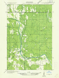
 1932 Helena SW1932 Print · USGSMarquette County’s timber country comes into focus in the early 1930s, showing the railroad and logging camps that drove the regional economy. Researchers can locate vanished sites like John Bruce Camp, the Finnish Sch, and the Arnold PO along the Escanaba and Lake Superior line.
 - 1932 Map of Rock NW
 1932 Rock NW1932 Print · USGSMarquette and Delta counties are shown in the early thirties when logging camps and railroads defined life in the Upper Peninsula. Genealogists can trace family-named outposts like Selins Camp, Stenlund Camp, and the settlement of McFarland.
 - 1932 Map of Harvey NE
 1932 Harvey NE1932 Print · USGSMarquette County's shoreline and rural school districts are captured here in the early thirties. Genealogists and historians can trace the local landscape through the Marquette Landing Field and numerous country schools like Cherry Sch and Heidman Sch.
 - 1932 Map of Helena
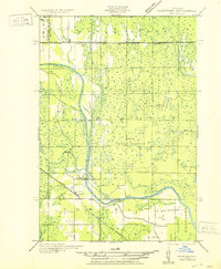
 1932 Helena1932 Print · USGSMarquette County's river valleys and rail corridors are captured here in the early thirties as the region transitioned from logging camps to settled townships. Researchers can locate community anchors like the Town Hall and Lincoln Sch or trace the early industrial footprint of the Chicago and Northwestern railroad.2 unique versions available
 - 1932 Map of Gladstone NW
 1932 Gladstone NW1932 Print · USGSThe Escanaba River valley in the early 1930s shows a landscape defined by timber and transport. Genealogists and researchers can trace the rural communities of Cornell and Salva, alongside local schoolhouses like St Nicholas Sch and Chandler Sch.
 - 1950 Map of Skandia NW
 1950 Skandia NW1950 Print · USGSThe Marquette County shoreline and timberlands come into focus at mid-century, where rail lines and river forks meet. Genealogists and historians can trace the foundations of Yalmer and New Dalton through the Yalmer Sch and Skandia Cem.
 - 1950 Map of Gladstone NW
 1950 Gladstone NW1950 Print · USGSThe Upper Peninsula logging and rail landscape comes alive in this mid-century survey of the Escanaba River valley. Genealogists can locate family-named landmarks like Larsons Camp and rural sites such as St Nicholas Sch and the hamlet of Cornell.
 - 1951 Map of Helena SW
 1951 Helena SW1951 Print · USGSMarquette County's logging and rail corridor is captured here in the early 1950s, showing the intersection of timber camps and rural school life. Researchers can trace the Escanaba and Lake Superior line to Watson, the Arnold PO, and the Finnish Sch.
 - 1951 Map of Helena
 1951 Helena1951 Print · USGSMarquette County in the early thirties shows a landscape of river-driven industry and rural school districts. Genealogists and historians can trace the foundations of local education at Ewing Sch and Lincoln Sch or locate the sites of Finn Camp and Sherkeys Camp.2 unique versions available
 - 1951 Map of Helena NE
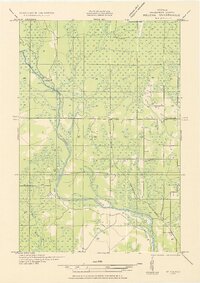
 1951 Helena NE1951 Print · USGSMarquette County's interior timberlands and marshes come into focus in the early 1950s, showing a landscape defined by seasonal outposts and rail transit. Genealogists and historians can trace old sites like Rochenon Camp, Helena, and the Parker Spur rail siding.
 - 1951 Map of Helena NW
 1951 Helena NW1951 Print · USGSMarquette County’s interior during the early 1950s was a landscape of remote camps and heavy industry centered on the Escanaba River. Genealogists and historians can trace old logging outposts like Faucett Camp and the rail operations of the Chicago and North Western.
Showing maps 1-25 of 408
Top cities of Marquette County
Frequently asked questions
- What are the different types of historical maps available for Marquette County?
- What is the oldest map of Marquette County?
- Where can I purchase historical maps of Marquette County for my home or office?
- Where can I download high-res historical maps of Marquette County?
- Are there historical topographic maps available for Marquette County?
- Is there historical aerial imagery available for Marquette County?
- Where are historical maps of Marquette County sourced from?