1960s Maps of Monroe County, Michigan
Explore 17 historic maps of Monroe County from the 1960s. These maps offer a rare glimpse into what life looked like during the 1960s — showing old roads, neighborhoods, homes, and landmarks that have changed or disappeared over time.
Whether you're researching your family's past, planning a metal detecting trip, or studying how Monroe County's landscape evolved across the 1960s, these high-resolution maps are a powerful tool for exploring the history of this region.
- Focus on a specific era: All maps on this page are from the 1960s, giving you a focused view of this time period.
- See what’s changed: Compare century-old streets, trails, and buildings to today's modern landscape using overlays and satellite layers.
- Research with precision: Use these maps for genealogy, historical research, land use analysis, or educational projects.
- View, download, or print: Maps are fully viewable online in high resolution, and can be downloaded or printed for your own records.
Start exploring Monroe County's history through authentic maps from the 1960s. This is your window into the past.
Monroe County, MI maps
(17)- 1961 Map of Toledo
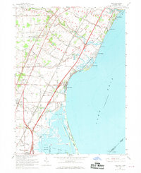
 1961 Toledo1961 Print · USGSThe western basin of Lake Erie and the industrial heart of Northern Ohio are captured here during the post-war era. Researchers can trace historical rail lines like the New York Central or locate landmarks like the Erie Ordnance Depot and Pelee Island.
 - 1961 Map of Detroit, 1973 Print
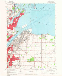
 1961 Detroit1973 Print · USGSThe international border between Michigan and Ontario was a bustling industrial corridor in the early sixties. Researchers can trace the transit networks and riverfront infrastructure connecting Detroit to Windsor via the Detroit-Windsor Tunnel and major air hubs like Willow Run Airport.2 unique versions available
 - 1965 Map of Detroit
 1965 Detroit1965 Print · USGSThe industrial corridor between Michigan and Ontario is captured here at mid-century, showing the dense rail and river networks of the Great Lakes. Local historians can trace the paths of the Grand Trunk Western RR and locate key landmarks like Selfridge Air Force Base and Grosse Ile.
 - 1965 Map of Oregon, 1966 Print
 1965 Oregon1966 Print · USGSThe industrial shoreline of Lake Erie comes alive in the mid-sixties, where the heavy rail yards of Toledo meet the growing suburbs of Oregon. Trace family roots at St Ignatius Ch or locate mid-century landmarks like the Drive-in Theater and Clay High Sch.5 unique versions available
 - 1965 Map of Sylvania, 1967 Print
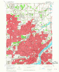
 1965 Sylvania1967 Print · USGSGreater Toledo and Sylvania are captured during a period of significant suburban expansion in the mid-1960s. Genealogists and local historians can map out family landmarks like Toledo Memorial Park, St Theresa Ch, and schools from Silica to Ottawa Hills.3 unique versions available
 - 1965 Map of Toledo, 1968 Print
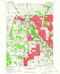
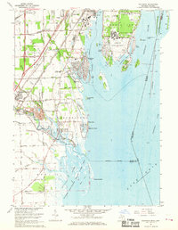
 1965 Toledo1968 Print · USGSToledo at the height of its mid-century development shows a landscape defined by the Maumee River and a massive rail network. Genealogists can trace family roots through neighborhood schools like DeVilbiss High Sch and find resting places in Woodlawn Cemetery.4 unique versions available
 - 1966 Map of Berkey, 1968 Print
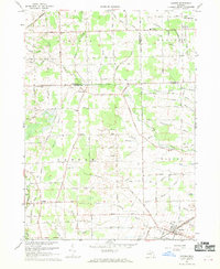
 1966 Berkey1968 Print · USGSThe Ohio-Michigan borderlands show their mid-century agricultural character in this detailed survey. Genealogists and local historians can trace family locations near Berkey, Richfield Center, and the Wolfinger Cem.2 unique versions available
 - 1967 Map of Estral Beach, 1969 Print
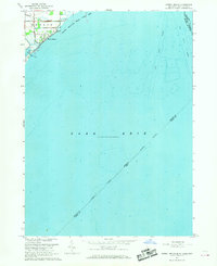 1967 Estral Beach1969 Print · USGSThe western shores of Lake Erie come into focus in the late 1960s, showing the intersection of coastal marshlands and international shipping lanes. Trace the development of Estral Beach or locate early family holdings near Langton and the Pointe Mouillee State Game Area.2 unique versions available
 - 1967 Map of Macon, 1969 Print
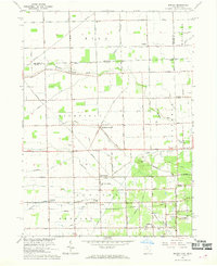
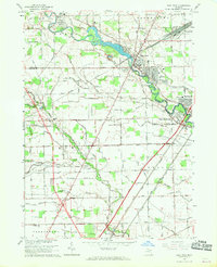
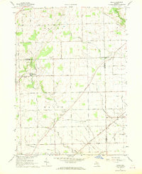 1967 Macon1969 Print · USGSThe tri-county borderlands of Lenawee, Washtenaw, and Monroe are captured here in the late sixties as agricultural life and rail transport intersected. Genealogists can locate family-named plots at Benton Cem and Welch Cem or trace the Norfolk and Western Railway through Cone.2 unique versions available
 - 1967 Map of Monroe, 1969 Print
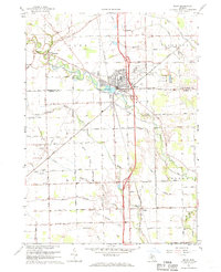
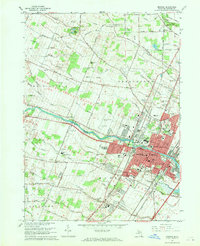 1967 Monroe1969 Print · USGSMonroe and its surrounding townships show a mix of industrial growth and rural tradition during the late sixties. Genealogists can trace family names through several burial grounds, including McIntyre Cem and Woodland Cem, while mapping the expansion of South Monroe.3 unique versions available
 - 1967 Map of Carleton, 1969 Print
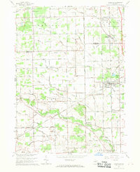 1967 Carleton1969 Print · USGSSoutheast Michigan's rural landscape is captured here in the late 1960s as a network of rail lines and drainage canals connected small farming communities. Genealogists can trace family landmarks like Woodmere Cem, St Patricks Sch, and the village of Waltz.3 unique versions available
 - 1967 Map of Erie, 1969 Print
 1967 Erie1969 Print · USGSThe Lake Erie shoreline in the late sixties reveals a landscape of industrial power and lakeside recreation at the Michigan-Ohio border. Researchers can trace the rail lines of the Penn Central, locate the St Joseph Sch in Erie, or explore the coastal reaches of the Woodtick Peninsula.2 unique versions available
 - 1967 Map of Rockwood, 1969 Print
 1967 Rockwood1969 Print · USGSCoastal Wayne County enters the late sixties as a hub of naval aviation and heavy river traffic along the Detroit River islands. Genealogists and local historians can trace the foundations of East Rockwood, the Grosse Ile Naval Air Station, and Gibraltar Cem.3 unique versions available
 - 1967 Map of Maybee, 1969 Print
 1967 Maybee1969 Print · USGSSoutheast Michigan’s agricultural heartland is mapped here in the late sixties, where family-named drains and county lines converge. Researchers can trace the Old Indian Treaty Boundary and locate family history at Bethlehem Ch, St Josephs Cem, or the Brainard Sch.
 - 1967 Map of Stony Point, 1969 Print
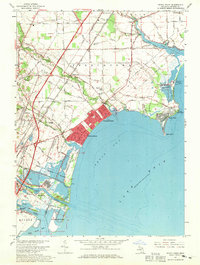 1967 Stony Point1969 Print · USGSMonroe County’s Lake Erie shoreline is a dense patchwork of mid-century suburban beaches and heavy industry. Genealogists and local historians can trace family roots through the Old St Charles Cem, explore early aviation at Marshall Airport, or locate small rural hubs like Oldport.3 unique versions available
 - 1967 Map of Flat Rock, 1969 Print
 1967 Flat Rock1969 Print · USGSThe Huron River valley in the late sixties shows a landscape of industrial rail yards and growing residential communities. Genealogists can trace family landmarks like Ash-Center Cem, St Rochs Ch, and the many schools serving Flat Rock and Newport.2 unique versions available
 - 1967 Map of Milan, 1970 Print
 1967 Milan1970 Print · USGSSoutheast Michigan in the late sixties reveals a landscape of thriving township centers and sprawling agricultural drains. Genealogists and local historians can trace family plots at Marble Park Cemetery or follow the historic Old Indian Treaty Boundary near Azalia.2 unique versions available
End of results
Showing maps 1-17 of 17
Top cities of Monroe County
- Bedford Township historical maps
- Frenchtown Charter Township historical maps
- Monroe historical maps
- Monroe Charter Township historical maps
- Berlin Charter Township historical maps
- Ash Township historical maps
See more
Frequently asked questions
- What are the different types of historical maps available for Monroe County?
- What is the oldest map of Monroe County?
- Where can I purchase historical maps of Monroe County for my home or office?
- Where can I download high-res historical maps of Monroe County?
- Are there historical topographic maps available for Monroe County?
- Is there historical aerial imagery available for Monroe County?
- Where are historical maps of Monroe County sourced from?