1940s Maps of Monroe County, Michigan
Explore 14 historic maps of Monroe County from the 1940s. These maps offer a rare glimpse into what life looked like during the 1940s — showing old roads, neighborhoods, homes, and landmarks that have changed or disappeared over time.
Whether you're researching your family's past, planning a metal detecting trip, or studying how Monroe County's landscape evolved across the 1940s, these high-resolution maps are a powerful tool for exploring the history of this region.
- Focus on a specific era: All maps on this page are from the 1940s, giving you a focused view of this time period.
- See what’s changed: Compare century-old streets, trails, and buildings to today's modern landscape using overlays and satellite layers.
- Research with precision: Use these maps for genealogy, historical research, land use analysis, or educational projects.
- View, download, or print: Maps are fully viewable online in high resolution, and can be downloaded or printed for your own records.
Start exploring Monroe County's history through authentic maps from the 1940s. This is your window into the past.
Monroe County, MI maps
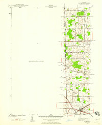
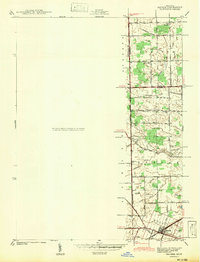
(14)- 1940 Map of Ida
 1940 Ida1940 Print · USGSMonroe County farmland and the village of Ida are captured here just before the war, when the New York Central railroad still fueled local transit. Researchers can trace rural school districts like King Sch and find family sites near Immanuel Cem.2 unique versions available
 - 1940 Map of Maybee
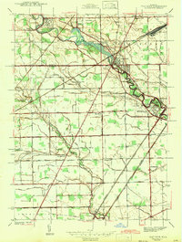
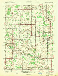
 1940 Maybee1940 Print · USGSSoutheast Michigan's rural townships are documented here in the early 1940s as the railroad fueled local growth. You can trace early family homesteads near the Stony Creek Cem or locate old school sites like Clayton Sch and Columbia Sch.
 - 1940 Map of Dundee
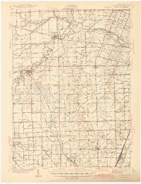
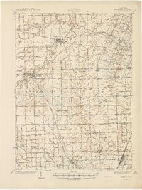 1940 Dundee1940 Print · USGSMonroe County's rural landscape is captured here in the late 1930s, showing a network of rail-side towns and country schools. Genealogists can locate family landmarks like St Joseph Cem, Hull Sch, and the riverside settlement of Dundee.
 - 1941 Map of Samaria
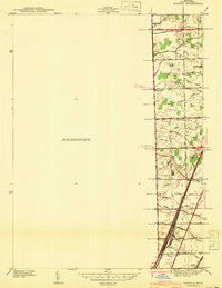 1941 Samaria1941 Print · USGSMonroe County was a hub of rail traffic and rural farming just before the war, with dense networks of drainage canals and country schools. Researchers can trace family roots through the St Joseph Cem, find the old Dean Sch, or explore the rail works at Ottawa Yard.
 - 1941 Map of Blissfield
 1941 Blissfield1941 Print · USGSSoutheastern Michigan is captured here just before the war, showcasing a landscape defined by the winding Raisin River and its busy rail corridors. Genealogists and historians can trace dozens of country schoolhouses like Centennial Sch and family landmarks near Blissfield and Lenawee Junction.2 unique versions available
 - 1941 Map of Dundee
 1941 Dundee1941 Print · USGSMonroe County was a thriving network of rail lines and rural school districts in the years just before the war. Genealogists can trace family landmarks and local institutions like St Anthonys Ch, Maplegrove Cem, and dozens of named schools including Hull Sch.2 unique versions available
 - 1942 Map of Flat Rock
 1942 Flat Rock1942 Print · USGSThe Detroit-Toledo corridor comes into focus just before the mid-century, where the Huron River meets a network of major railroads and early highways. Genealogists and local historians can trace rural schoolhouses like Bancroft Sch and Peters Sch, or locate family plots within Riverside Cem and Oakwood Cem.2 unique versions available
 - 1942 Map of Maybee
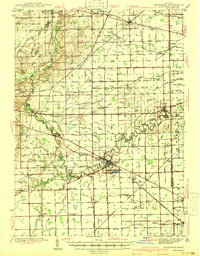
 1942 Maybee1942 Print · USGSSoutheastern Michigan farmlands near the Monroe and Wayne county lines are documented here in the early 1940s. Genealogists can trace family landmarks like the Sandy Hill Cem and old school sites including Palmer Sch and Clayton Sch.
 - 1942 Map of Stony Point
 1942 Stony Point1942 Print · USGSMonroe County's Lake Erie shoreline was a thriving mix of coastal resorts and rail infrastructure in the 1940s. Researchers can trace family sites at St. Charles Cem, explore coastal developments like Woodland Beach, or locate rural landmarks like Scrabble Hollow Sch.2 unique versions available
 - 1942 Map of Rockwood
 1942 Rockwood1942 Print · USGSThe Downriver shoreline and Grosse Ile appear here in the early 1940s as the region's shipping and rail networks expanded. Genealogists and historians can trace local landmarks like St Marys Cem, the Powderhouse, and small settlements such as Milleville Beach.2 unique versions available
 - 1942 Map of Monroe
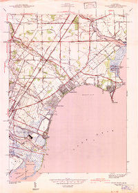
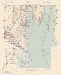
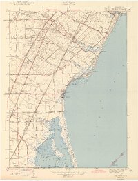
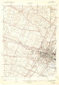 1942 Monroe1942 Print · USGSMonroe and its riverfront townships are shown here in the early 1940s, revealing a busy rail corridor and the city's growth. Genealogists can trace family sites like Sandy Creek Cem, St Marys Academy, and the County Infirmary.2 unique versions available
 - 1942 Map of Estral Beach
 1942 Estral Beach1942 Print · USGSThe Monroe County shoreline comes into focus during the early 1940s, highlighting the coastal community at Estral Beach and its relationship with the lake. Genealogists and historians can trace local development in Berlin township along Langton Creek and Port Sunlight Rd.2 unique versions available
 - 1942 Map of Carleton
 1942 Carleton1942 Print · USGSMonroe and Wayne counties come into focus during the early 1940s, showing a landscape shaped by rail-line junctions and agricultural drains. Genealogists can trace family names through landmarks like Felt Cem, St Patricks Cem, and local schoolhouses like Willow Sch or Long Bridge Sch.2 unique versions available
 - 1943 Map of Erie
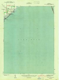
 1943 Erie1943 Print · USGSThe Lake Erie shoreline in the early 1940s reveals a landscape of coastal marshes, growing beach communities, and vital rail corridors. Genealogists can locate family landmarks such as La Salle Cem and numerous country schools like San Freal Sch and Moran Sch.3 unique versions available
End of results
Showing maps 1-14 of 14
Top cities of Monroe County
- Bedford Township historical maps
- Frenchtown Charter Township historical maps
- Monroe historical maps
- Monroe Charter Township historical maps
- Berlin Charter Township historical maps
- Ash Township historical maps
See more
Frequently asked questions
- What are the different types of historical maps available for Monroe County?
- What is the oldest map of Monroe County?
- Where can I purchase historical maps of Monroe County for my home or office?
- Where can I download high-res historical maps of Monroe County?
- Are there historical topographic maps available for Monroe County?
- Is there historical aerial imagery available for Monroe County?
- Where are historical maps of Monroe County sourced from?