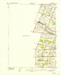
1940 Map of Ida
USGS Topo · Published 1940About this map
The Raisin River winds through this rural Monroe County landscape, defining the agricultural and social layout of the region just before the 1940s. Centered on the village of Ida, the map reveals a network of small school districts and rural parishes that anchored the community during this era. Education was localized in landmarks like Bridge Sch, Grape Sch, and Maple Grove Sch, while spiritual life centered on Immanuel Ch and its adjacent Immanuel Cem.
Find a feature on this map
58 named features on this map. Tap any name to fly to it.
Don’t see what you’re looking for? This feature index may not catch every label — zoom into the map to look around manually.
Map Details
Editions of this 1940 Ida Map
2 editions found
Other maps of this area

1902 · Ypsilanti
USGS Topo · 1:62,500

1904 · Ann Arbor
USGS Topo · 1:125,000

1906 · Ypsilanti
USGS Topo · 1:62,500

1906 · Romulus
USGS Topo · 1:62,500

1908 · Ann Arbor
USGS Topo · 1:125,000

1912 · Monroe
USGS Topo · 1:62,500

1912 · Dundee
USGS Topo · 1:62,500

1914 · Monroe
USGS Topo · 1:62,500

1926 · Dundee
USGS Topo · 1:62,500

1927 · Monroe
USGS Topo · 1:31,680