1930s Maps of Monroe County, Michigan
Explore 17 historic maps of Monroe County from the 1930s. These maps offer a rare glimpse into what life looked like during the 1930s — showing old roads, neighborhoods, homes, and landmarks that have changed or disappeared over time.
Whether you're researching your family's past, planning a metal detecting trip, or studying how Monroe County's landscape evolved across the 1930s, these high-resolution maps are a powerful tool for exploring the history of this region.
- Focus on a specific era: All maps on this page are from the 1930s, giving you a focused view of this time period.
- See what’s changed: Compare century-old streets, trails, and buildings to today's modern landscape using overlays and satellite layers.
- Research with precision: Use these maps for genealogy, historical research, land use analysis, or educational projects.
- View, download, or print: Maps are fully viewable online in high resolution, and can be downloaded or printed for your own records.
Start exploring Monroe County's history through authentic maps from the 1930s. This is your window into the past.
Monroe County, MI maps
(17)- 1934 Map of Point Place
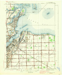
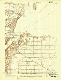 1934 Point Place1934 Print · USGSThe Lake Erie shoreline near Toledo comes to life in the mid-1930s, showing a landscape defined by maritime trade and residential growth. Genealogists and historians can trace family locations near Point Place, Momineetown, and landmarks like the Toledo Yacht Club.
 - 1935 Map of Berkey
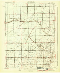
 1935 Berkey1935 Print · USGSLucas County farms and small crossroads settlements are captured here in the mid-1930s as the region transitioned from electric rail to highway travel. Researchers can trace family sites near Wolfinger Cem, the St Elizabeth Sch Richfield Center, and the industrial spur at Allen Junction.
 - 1936 Map of Samaria
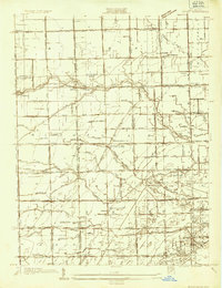
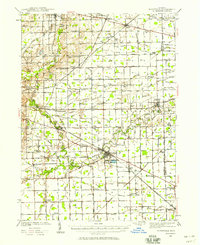
 1936 Samaria1936 Print · USGSDuring the mid-1930s, this corridor north of the Michigan-Ohio border was a hub of drainage projects and rail expansion. Researchers can trace the layout of the Ottawa Yard, the site of Vienna Junction, and local landmarks like Erie Union Cem and Yargerville Sch.
 - 1936 Map of Rockwood
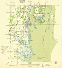 1936 Rockwood1936 Print · USGSCoastal Wayne County and the Detroit River islands are shown here in the mid-thirties, just as the aviation and shipping industries were maturing. Researchers can locate the U S Naval Reserve Aviation Base on Grosse Ile, the St Marys Cem, and the marshy expanses around Point Mouillee.
 - 1936 Map of Stony Point
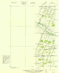
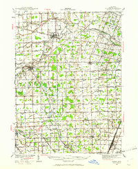
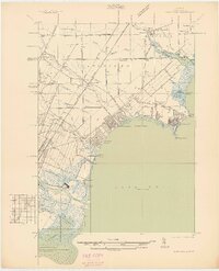 1936 Stony Point1936 Print · USGSMonroe County’s Lake Erie shoreline was a burgeoning corridor of summer beaches and rail transport in the mid-1930s. Genealogists and researchers can trace family-named schools like Loranger Sch and Masserant Sch, or locate the historic St Charles Cem near Oldport.2 unique versions available
 - 1936 Map of Flat Rock
 1936 Flat Rock1936 Print · USGSSoutheast Michigan's riverfront and rail corridors are captured here in the mid-1930s as industrial yards and rural townships began to interface. Researchers can trace ancestral roots through dozens of local landmarks including Ash Center Cem, Maple Grove Sch, and the unique settlement at Scrabble.
 - 1936 Map of Erie
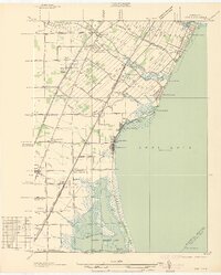 1936 Erie1936 Print · USGSCoastal Monroe County in the mid-1930s shows a landscape of lakeside resorts and busy rail corridors heading toward the Ohio line. Genealogists and local historians can locate early twentieth-century landmarks like San Freal Sch, Luna Pier, and the Roselawn Memorial Cem.
 - 1936 Map of Maybee
 1936 Maybee1936 Print · USGSThe Monroe and Wayne County borderlands are captured here in the mid-1930s, showing a rural landscape defined by rail and drainage. Trace the Detroit Toledo & Ironton RR through Maybee or locate family sites like Palmer Sch and Sandy Hill Cem.
 - 1936 Map of Ida
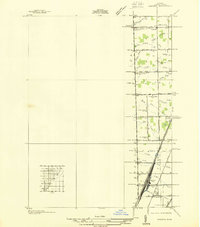
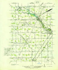
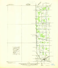
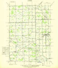
 1936 Ida1936 Print · USGSMonroe County agriculture and rural life are captured here in the mid-1930s as a complex network of drains and creeks shaped the land. Researchers can locate several country schoolhouses like Grape Sch, the Immanuel Cem, and the village of Strasburg.
 - 1936 Map of Carleton
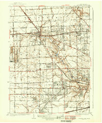
 1936 Carleton1936 Print · USGSSoutheast Michigan farm country is captured here during the mid-thirties, showing the rural landscape surrounding the village of Carleton. Researchers can trace old family schoolhouses like Long Bridge Sch and early church sites including St Johns Ch along the Pere Marquette line.
 - 1937 Map of Sylvania
 1937 Sylvania1937 Print · USGSSylvania and the Ohio-Michigan borderlands are shown in the mid-1930s as limestone extraction and suburban neighborhoods began to reshape the landscape. Researchers can trace local industry at Medusa Quarry or locate vanished rural landmarks like Dorr St Sch and the Boy Scout Reservation.2 unique versions available
 - 1938 Map of Toledo
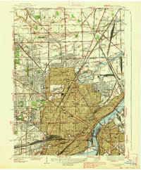 1938 Toledo1938 Print · USGSIn the late thirties, this industrial hub was defined by the confluence of the Maumee River and an immense railroad network. Genealogists and historians can trace the early layout of Toledo University, numerous family cemeteries like Southard Cem, and rail landmarks including Air Line Junction.2 unique versions available
 - 1938 Map of Point Place
 1938 Point Place1938 Print · USGSCoastal life and heavy industry intersect along Maumee Bay in the late thirties as the region’s rail and maritime networks expanded. Researchers can trace the heritage of Point Place, the waterfront Naval Armory, and rural settlements like Momeneetown and Booth.2 unique versions available
 - 1939 Map of Berkey
 1939 Berkey1939 Print · USGSNorthwest Ohio at the end of the Depression reveals a landscape defined by rail transit and reclaimed wetlands. Trace the path of the Toledo and Western Railroad or locate family roots near Richfield Center and the Immaculate Conception Sch.3 unique versions available
 - 1939 Map of Blissfield, 1958 Print
 1939 Blissfield1958 Print · USGSSoutheastern Michigan agriculture and industry are in full view during the late 1930s as a dense network of railroads and rivers connects small farm towns. Local historians can trace the locations of dozens of vanished schools like Ford Sch and rail junctions like Lenawee Junction.
 - 1939 Map of Samaria, 1959 Print
 1939 Samaria1959 Print · USGSMonroe County farmland and early transport corridors are documented here just before the 1940s. Genealogists and local historians can trace family roots through Zion Ch, St Joseph Cem, and vanished schoolhouses like Dean Sch.
 - 1939 Map of Dundee, 1961 Print
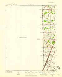
 1939 Dundee1961 Print · USGSMonroe County before the war was a landscape of river-bend towns and rural school districts linked by an intricate rail and water network. Genealogists can locate family landmarks such as St Anthonys Ch, Wells Sch, and numerous burial grounds like Oak Grove Cem.2 unique versions available
End of results
Showing maps 1-17 of 17
Top cities of Monroe County
- Bedford Township historical maps
- Frenchtown Charter Township historical maps
- Monroe historical maps
- Monroe Charter Township historical maps
- Berlin Charter Township historical maps
- Ash Township historical maps
See more
Frequently asked questions
- What are the different types of historical maps available for Monroe County?
- What is the oldest map of Monroe County?
- Where can I purchase historical maps of Monroe County for my home or office?
- Where can I download high-res historical maps of Monroe County?
- Are there historical topographic maps available for Monroe County?
- Is there historical aerial imagery available for Monroe County?
- Where are historical maps of Monroe County sourced from?