1900s (20th Century) Maps of Estral Beach, Berlin Charter Township
Explore 6 historic maps of Estral Beach from the 1900s (20th Century). These maps offer a rare glimpse into what life looked like during the 1900s — showing old roads, neighborhoods, homes, and landmarks that have changed or disappeared over time.
Whether you're researching your family's past, planning a metal detecting trip, or studying how Estral Beach's landscape evolved across the 1900s, these high-resolution maps are a powerful tool for exploring the history of this region.
- Focus on a specific era: All maps on this page are from the 1900s, giving you a focused view of this time period.
- See what’s changed: Compare century-old streets, trails, and buildings to today's modern landscape using overlays and satellite layers.
- Research with precision: Use these maps for genealogy, historical research, land use analysis, or educational projects.
- View, download, or print: Maps are fully viewable online in high resolution, and can be downloaded or printed for your own records.
Start exploring Estral Beach's history through authentic maps from the 1900s. This is your window into the past.
Estral Beach, Berlin Charter Township maps
(6)- 1942 Map of Estral Beach
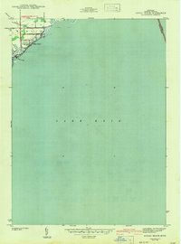 1942 Estral Beach1942 Print · USGSThe Monroe County shoreline comes into focus during the early 1940s, highlighting the coastal community at Estral Beach and its relationship with the lake. Genealogists and historians can trace local development in Berlin township along Langton Creek and Port Sunlight Rd.2 unique versions available
 - 1952 Map of Estral Beach, 1953 Print
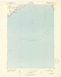 1952 Estral Beach1953 Print · USGSThe Lake Erie shoreline in Monroe County was a mix of quiet beach communities and coastal wetlands during the early fifties. Genealogists and historians can trace the early layout of Estral Beach and locate landmarks like the Submerged Wreck and Swan Creek.2 unique versions available
 - 1956 Map of Toledo, 1968 Print
 1956 Toledo1968 Print · USGSNorthwest Ohio and the Lake Erie shoreline are shown in detail during the late fifties, showcasing a landscape of heavy industry, railroads, and island communities. Genealogists and historians can trace rail networks like the Chesapeake & Ohio RR or locate landmarks such as the Erie Proving Ground and Kelleys Island.4 unique versions available
 - 1961 Map of Toledo
 1961 Toledo1961 Print · USGSThe western basin of Lake Erie and the industrial heart of Northern Ohio are captured here during the post-war era. Researchers can trace historical rail lines like the New York Central or locate landmarks like the Erie Ordnance Depot and Pelee Island.
 - 1967 Map of Estral Beach, 1969 Print
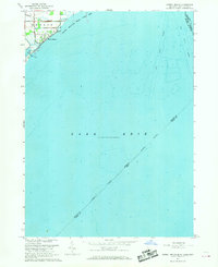 1967 Estral Beach1969 Print · USGSThe western shores of Lake Erie come into focus in the late 1960s, showing the intersection of coastal marshlands and international shipping lanes. Trace the development of Estral Beach or locate early family holdings near Langton and the Pointe Mouillee State Game Area.2 unique versions available
 - 1986 Map of Toledo
 1986 Toledo1986 Print · USGSGreater Toledo and the Lake Erie shoreline are captured here in the mid-eighties, showcasing a massive network of industrial waterways and rail lines. You can trace the path of the Maumee River past Rossford or explore the conservation lands at Ottawa National Wildlife Refuge.2 unique versions available
End of results
Showing maps 1-6 of 6
Top cities near Estral Beach
- Taylor historical maps
- Brownstown Charter Township historical maps
- Van Buren Charter Township historical maps
- Southgate historical maps
- Wyandotte historical maps
- Romulus historical maps
See more
Frequently asked questions
- What are the different types of historical maps available for Estral Beach?
- What is the oldest map of Estral Beach?
- Where can I purchase historical maps of Estral Beach for my home or office?
- Where can I download high-res historical maps of Estral Beach?
- Are there historical topographic maps available for Estral Beach?
- Is there historical aerial imagery available for Estral Beach?
- Where are historical maps of Estral Beach sourced from?