Old Maps of Maybee, Exeter Township for Genealogy
Trace your family roots with 34 historic maps of Maybee. These high-res maps reveal old neighborhoods, homesites, landmarks, and streets — helping you uncover where your ancestors lived and how the area evolved over time.
- Explore historic neighborhoods: Identify where your relatives may have lived in the 1800s or 1900s.
- Compare maps over time: Trace the changes in streets, buildings, and landmarks for multi-generational research.
- Perfect for genealogy & ancestry research: Used by family historians and researchers to map out lineage and migration.
These maps are an incredible resource for exploring your personal connection to Maybee's past.
Maybee, Exeter Township maps
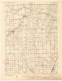
(34)- 1902 Map of Ypsilanti, 1958 Print
 1902 Ypsilanti1958 Print · USGSSoutheast Michigan at the turn of the century shows a landscape defined by thriving rail towns and winding river valleys. Genealogists and historians can trace the early footprints of Ypsilanti or find smaller locales like Rawsonville and Azalia along the Huron River and Michigan Central RR.
 - 1904 Map of Ann Arbor
 1904 Ann Arbor1904 Print · USGSEarly twentieth-century Washtenaw County comes to life through its dense network of interurban electric lines and steam railroads. Researchers can trace the layout of Ann Arbor, locate the Duck Lake School, or find vanished stops along the Michigan Central R. R. and Ann Arbor R. R..2 unique versions available
 - 1906 Map of Ypsilanti
 1906 Ypsilanti1906 Print · USGSSoutheast Michigan at the dawn of the century reveals a landscape defined by its bustling river towns and burgeoning rail networks. Trace the early development of Ypsilanti and Milan or locate vanished stops along the Michigan Central RR and the Wabash RR.3 unique versions available
 - 1908 Map of Ann Arbor
 1908 Ann Arbor1908 Print · USGSSoutheast Michigan at the turn of the century shows a landscape transitioning through the arrival of electric rail and the growth of the Huron River valley. Genealogists and researchers can trace old family lands near Saline, Ypsilanti, and Whitmore Lake, or follow the path of the Michigan Central RR.
 - 1912 Map of Dundee
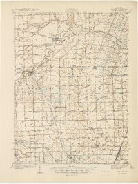
 1912 Dundee1912 Print · USGSMonroe County was a bustling intersection of rail and river commerce just before the First World War. Local historians can trace the exact routes of the Cincinnati Northern R. R. and the Ann Arbor R. R. as they pass through Dundee and Petersburg.
 - 1926 Map of Dundee
 1926 Dundee1926 Print · USGSSoutheastern Michigan is captured here during the height of the steam-rail era, showing the intricate network of Monroe County townships. Genealogists and historians can trace family locations near Dundee, Lambertville, or the rail junctions at Ida and Strasburgh.
 - 1936 Map of Maybee
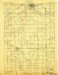
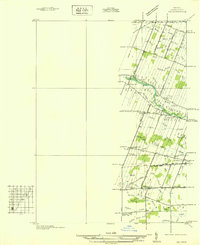
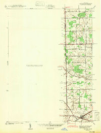
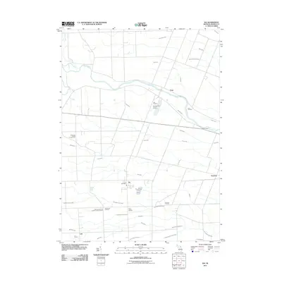
 1936 Maybee1936 Print · USGSThe Monroe and Wayne County borderlands are captured here in the mid-1930s, showing a rural landscape defined by rail and drainage. Trace the Detroit Toledo & Ironton RR through Maybee or locate family sites like Palmer Sch and Sandy Hill Cem.
 - 1936 Map of Ida
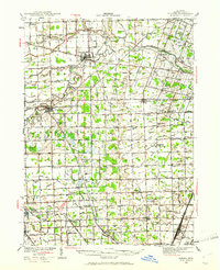
 1936 Ida1936 Print · USGSMonroe County agriculture and rural life are captured here in the mid-1930s as a complex network of drains and creeks shaped the land. Researchers can locate several country schoolhouses like Grape Sch, the Immanuel Cem, and the village of Strasburg.
 - 1939 Map of Dundee, 1961 Print
 1939 Dundee1961 Print · USGSMonroe County before the war was a landscape of river-bend towns and rural school districts linked by an intricate rail and water network. Genealogists can locate family landmarks such as St Anthonys Ch, Wells Sch, and numerous burial grounds like Oak Grove Cem.2 unique versions available
 - 1940 Map of Ida
 1940 Ida1940 Print · USGSMonroe County farmland and the village of Ida are captured here just before the war, when the New York Central railroad still fueled local transit. Researchers can trace rural school districts like King Sch and find family sites near Immanuel Cem.2 unique versions available
 - 1940 Map of Maybee
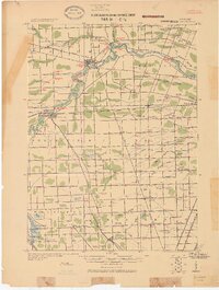
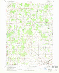
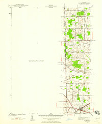 1940 Maybee1940 Print · USGSSoutheast Michigan's rural townships are documented here in the early 1940s as the railroad fueled local growth. You can trace early family homesteads near the Stony Creek Cem or locate old school sites like Clayton Sch and Columbia Sch.
 - 1940 Map of Dundee
 1940 Dundee1940 Print · USGSMonroe County's rural landscape is captured here in the late 1930s, showing a network of rail-side towns and country schools. Genealogists can locate family landmarks like St Joseph Cem, Hull Sch, and the riverside settlement of Dundee.
 - 1941 Map of Dundee
 1941 Dundee1941 Print · USGSMonroe County was a thriving network of rail lines and rural school districts in the years just before the war. Genealogists can trace family landmarks and local institutions like St Anthonys Ch, Maplegrove Cem, and dozens of named schools including Hull Sch.2 unique versions available
 - 1942 Map of Maybee
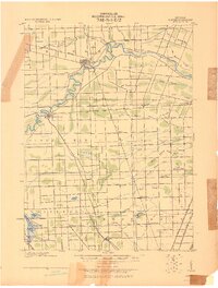
 1942 Maybee1942 Print · USGSSoutheastern Michigan farmlands near the Monroe and Wayne county lines are documented here in the early 1940s. Genealogists can trace family landmarks like the Sandy Hill Cem and old school sites including Palmer Sch and Clayton Sch.
 - 1954 Map of Detroit
 1954 Detroit1954 Print · USGSThe Detroit metro and its Ontario neighbors are shown at the height of the mid-century industrial era, just as the suburbs were rapidly expanding. Researchers can trace the massive rail networks of the Wabash Railroad or locate landmarks like Grosse Ile and Selfridge Air Force Base.
 - 1956 Map of Toledo, 1968 Print
 1956 Toledo1968 Print · USGSNorthwest Ohio and the Lake Erie shoreline are shown in detail during the late fifties, showcasing a landscape of heavy industry, railroads, and island communities. Genealogists and historians can trace rail networks like the Chesapeake & Ohio RR or locate landmarks such as the Erie Proving Ground and Kelleys Island.4 unique versions available
 - 1961 Map of Toledo
 1961 Toledo1961 Print · USGSThe western basin of Lake Erie and the industrial heart of Northern Ohio are captured here during the post-war era. Researchers can trace historical rail lines like the New York Central or locate landmarks like the Erie Ordnance Depot and Pelee Island.
 - 1961 Map of Detroit, 1973 Print
 1961 Detroit1973 Print · USGSThe international border between Michigan and Ontario was a bustling industrial corridor in the early sixties. Researchers can trace the transit networks and riverfront infrastructure connecting Detroit to Windsor via the Detroit-Windsor Tunnel and major air hubs like Willow Run Airport.2 unique versions available
 - 1965 Map of Detroit
 1965 Detroit1965 Print · USGSThe industrial corridor between Michigan and Ontario is captured here at mid-century, showing the dense rail and river networks of the Great Lakes. Local historians can trace the paths of the Grand Trunk Western RR and locate key landmarks like Selfridge Air Force Base and Grosse Ile.
 - 1967 Map of Maybee, 1969 Print
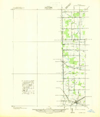
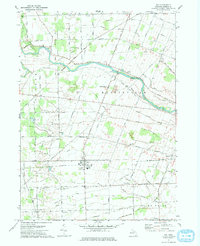
 1967 Maybee1969 Print · USGSSoutheast Michigan’s agricultural heartland is mapped here in the late sixties, where family-named drains and county lines converge. Researchers can trace the Old Indian Treaty Boundary and locate family history at Bethlehem Ch, St Josephs Cem, or the Brainard Sch.
 - 1972 Map of Ida, 1975 Print
 1972 Ida1975 Print · USGSMonroe County farmland and the village of Ida are captured in the early seventies as the region maintained its rural character. Genealogists and local historians can trace family locations through numerous rural burial grounds like St Joseph Cem and the Lulu Cem near the Lulu settlement.
 - 1985 Map of Detroit
 1985 Detroit1985 Print · USGSSoutheast Michigan in the mid-eighties shows a landscape defined by industrial power and suburban reach from the Detroit River to the Huron Valley. Researchers can trace the rail lines of the Conrail, explore the grounds of the University of Michigan, and locate numerous sites like Mt Olivet Cem.
 - 1986 Map of Toledo
 1986 Toledo1986 Print · USGSGreater Toledo and the Lake Erie shoreline are captured here in the mid-eighties, showcasing a massive network of industrial waterways and rail lines. You can trace the path of the Maumee River past Rossford or explore the conservation lands at Ottawa National Wildlife Refuge.2 unique versions available
 - 1989 Map of Detroit, 1991 Print
 1989 Detroit1991 Print · USGSSoutheast Michigan and across the river into Ontario reached a point of peak metropolitan density at the end of the 1980s. Local researchers can trace the footprint of the University of Michigan campus, the industrial waterfronts of Wyandotte, and the extensive grounds of Glen Eden Cem.
 - 2011 Map of Ida, 2011 Print
 2011 Ida2011 Print · USGSCovers Maybee, including Raisinville Township, Ida, and other nearby areas
Showing maps 1-25 of 34
Top cities near Maybee
- Ann Arbor historical maps
- Taylor historical maps
- Ypsilanti Charter Township historical maps
- Pittsfield Charter Township historical maps
- Brownstown Charter Township historical maps
- Bedford Township historical maps
See more
Frequently asked questions
- What are the different types of historical maps available for Maybee?
- What is the oldest map of Maybee?
- Where can I purchase historical maps of Maybee for my home or office?
- Where can I download high-res historical maps of Maybee?
- Are there historical topographic maps available for Maybee?
- Is there historical aerial imagery available for Maybee?
- Where are historical maps of Maybee sourced from?