1970s Maps of London Township, Michigan
Explore 2 historic maps of London Township from the 1970s. These maps offer a rare glimpse into what life looked like during the 1970s — showing old roads, neighborhoods, homes, and landmarks that have changed or disappeared over time.
Whether you're researching your family's past, planning a metal detecting trip, or studying how London Township's landscape evolved across the 1970s, these high-resolution maps are a powerful tool for exploring the history of this region.
- Focus on a specific era: All maps on this page are from the 1970s, giving you a focused view of this time period.
- See what’s changed: Compare century-old streets, trails, and buildings to today's modern landscape using overlays and satellite layers.
- Research with precision: Use these maps for genealogy, historical research, land use analysis, or educational projects.
- View, download, or print: Maps are fully viewable online in high resolution, and can be downloaded or printed for your own records.
Start exploring London Township's history through authentic maps from the 1970s. This is your window into the past.
London Township, MI maps
(2)- 1972 Map of Dundee, 1975 Print
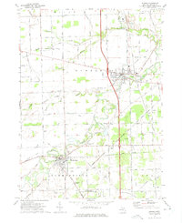 1972 Dundee1975 Print · USGSMonroe County's river valleys and rail corridors are captured here in the early seventies as the Raisin River winds between growing village centers. Genealogists and historians can locate rural landmarks like Maple Grove Cem, Petersburg Junction, and Gradolph Airfield.2 unique versions available
 - 1972 Map of Ida, 1975 Print
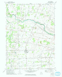 1972 Ida1975 Print · USGSMonroe County farmland and the village of Ida are captured in the early seventies as the region maintained its rural character. Genealogists and local historians can trace family locations through numerous rural burial grounds like St Joseph Cem and the Lulu Cem near the Lulu settlement.
End of results
Showing maps 1-2 of 2
Top cities near London Township
- Ann Arbor historical maps
- Canton Township historical maps
- Ypsilanti Charter Township historical maps
- Pittsfield Charter Township historical maps
- Bedford Township historical maps
- Van Buren Charter Township historical maps
See more
Top neighborhoods of London Township
Frequently asked questions
- What are the different types of historical maps available for London Township?
- What is the oldest map of London Township?
- Where can I purchase historical maps of London Township for my home or office?
- Where can I download high-res historical maps of London Township?
- Are there historical topographic maps available for London Township?
- Is there historical aerial imagery available for London Township?
- Where are historical maps of London Township sourced from?