1990s Maps of Haight Township, Michigan
Explore 8 historic maps of Haight Township from the 1990s. These maps offer a rare glimpse into what life looked like during the 1990s — showing old roads, neighborhoods, homes, and landmarks that have changed or disappeared over time.
Whether you're researching your family's past, planning a metal detecting trip, or studying how Haight Township's landscape evolved across the 1990s, these high-resolution maps are a powerful tool for exploring the history of this region.
- Focus on a specific era: All maps on this page are from the 1990s, giving you a focused view of this time period.
- See what’s changed: Compare century-old streets, trails, and buildings to today's modern landscape using overlays and satellite layers.
- Research with precision: Use these maps for genealogy, historical research, land use analysis, or educational projects.
- View, download, or print: Maps are fully viewable online in high resolution, and can be downloaded or printed for your own records.
Start exploring Haight Township's history through authentic maps from the 1990s. This is your window into the past.
Haight Township, MI maps
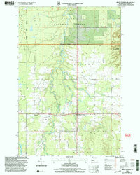
(8)- 1990 Map of Wakefield
 1990 Wakefield1990 Print · USGSThe Michigan-Wisconsin borderlands are captured here in the late twentieth century, showing the transition from an industrial rail-and-timber hub to a recreation-focused landscape. Trace the Chicago & North Western RR through Marenisco or locate landmarks like Agate Falls and Wakefield.
 - 1999 Map of Trout Creek, 2004 Print
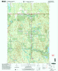
 1999 Trout Creek2004 Print · USGSOntonagon County is shown here at the turn of the millennium, centered on the logging and water-power landscapes of the Ottawa National Forest. Trace family roots near Agate Cem or explore the massive shoreline of the Bond Falls Flowage.
 - 1999 Map of Bruce Crossing, 2004 Print
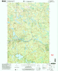
 1999 Bruce Crossing2004 Print · USGSUpper Peninsula timberlands and river valleys come to life in this late-century survey of Ontonagon County. Researchers can trace the local landscape around Bruce Crossing and Baltimore, locating family history sites like the Bruce Crossing Cem or the local Private Landing Strip.
 - 1999 Map of Paulding, 2004 Print
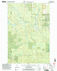
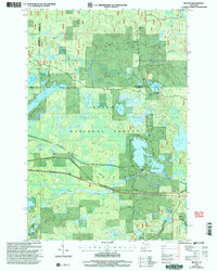
 1999 Paulding2004 Print · USGSUpper Peninsula timber and river country are captured here at the close of the twentieth century. Genealogists and local historians can trace the foundations of Paulding, find Maple Grove Cem, and locate old settlements like Robbins and Craigsmere.
 - 1999 Map of Fuller, 2004 Print
 1999 Fuller2004 Print · USGSThe Upper Peninsula wilderness of Gogebic County is captured here in the late twentieth century, showing a landscape defined by forest management and remote water systems. Genealogists and researchers can locate Fuller and the Interior Cem, or trace landmarks like Mex-i-min-e Falls and Burned Dam.
 - 1999 Map of Choate, 2004 Print
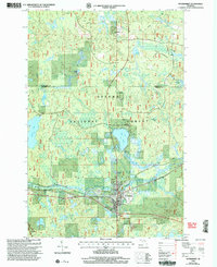
 1999 Choate2004 Print · USGSUpper Peninsula timberlands and river systems are documented here at the close of the twentieth century. Genealogists and outdoorsmen can trace remote waterways like the Cisco Branch Ontonagon River, locate Wolverine Falls, and find the settlement of Choate.
 - 1999 Map of Beaton, 2005 Print
 1999 Beaton2005 Print · USGSThe Upper Peninsula forest lands near Beaton are shown here in the late nineties as the region balanced wilderness preservation with forest management. Genealogists and researchers can trace the roads around Beaton Lake or locate the LANDING STRIP and Sylvania Wilderness boundary.
 - 1999 Map of Watersmeet, 2005 Print
 1999 Watersmeet2005 Print · USGSUpper Peninsula timberlands and river systems are documented here at the end of the century. Genealogists and local historians can trace the development of Watersmeet and Bonifas while locating family sites near the Cem and Ajibikoka Falls.
End of results
Showing maps 1-8 of 8
Top cities near Haight Township
Top neighborhoods of Haight Township
Frequently asked questions
- What are the different types of historical maps available for Haight Township?
- What is the oldest map of Haight Township?
- Where can I purchase historical maps of Haight Township for my home or office?
- Where can I download high-res historical maps of Haight Township?
- Are there historical topographic maps available for Haight Township?
- Is there historical aerial imagery available for Haight Township?
- Where are historical maps of Haight Township sourced from?