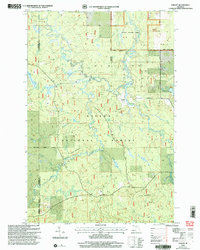
1999 Map of Choate
USGS Topo · Published 2004About this map
Ottawa National Forest dominates this landscape in the western Upper Peninsula, where the South Branch Ontonagon River and Cisco Branch Ontonagon River wind through a complex network of waterways. The small settlement of Choate serves as a focal point near the confluence of Sucker Creek and Choate Creek. The map documents a rugged terrain shaped by glacial activity, featuring Eighteen Mile Rapids and the dramatic Wolverine Falls. This late 20th-century revision captures the intersection of the Gogebic and Ontonagon county line, highlighting the administrative management of the Bergland, Watersmeet, and Bessemer ranger districts. For the local historian, the presence of a Gravel Pit near Stegner Lake and the naming of smaller tributaries like Custer Ash Creek and Snuffbox Creek provide specific landmarks for tracing land use and environmental shifts in this heavily forested region.
Find a feature on this map
21 named features on this map. Tap any name to fly to it.
Don’t see what you’re looking for? This feature index may not catch every label — zoom into the map to look around manually.
Map Details
Editions of this 1999 Choate Map
This is the sole edition of this map. No revisions or reprints were ever made.
Other maps of this area

1949 · Rockland
USGS Topo · 1:62,500

1951 · Rockland
USGS Topo · 1:62,500

1952 · Watersmeet
USGS Topo · 1:62,500

1952 · Thayer
USGS Topo · 1:62,500

1956 · Matchwood
USGS Topo · 1:62,500

1958 · Iron River
USGS Topo · 1:250,000

1960 · Iron River
USGS Topo · 1:250,000

1961 · Iron River
USGS Topo · 1:250,000

1967 · Iron River
USGS Topo · 1:250,000

1979 · Ontonagon
USGS Topo · 1:100,000
Featured Places
- Marenisco Township, MI
- McMillan Township, MI
- Haight Township, MI
- Gogebic County, MI
- Ontonagon County, MI