1930s Maps of Doyle Township, Michigan
Explore 7 historic maps of Doyle Township from the 1930s. These maps offer a rare glimpse into what life looked like during the 1930s — showing old roads, neighborhoods, homes, and landmarks that have changed or disappeared over time.
Whether you're researching your family's past, planning a metal detecting trip, or studying how Doyle Township's landscape evolved across the 1930s, these high-resolution maps are a powerful tool for exploring the history of this region.
- Focus on a specific era: All maps on this page are from the 1930s, giving you a focused view of this time period.
- See what’s changed: Compare century-old streets, trails, and buildings to today's modern landscape using overlays and satellite layers.
- Research with precision: Use these maps for genealogy, historical research, land use analysis, or educational projects.
- View, download, or print: Maps are fully viewable online in high resolution, and can be downloaded or printed for your own records.
Start exploring Doyle Township's history through authentic maps from the 1930s. This is your window into the past.
Doyle Township, MI maps
(7)- 1931 Map of Seney SW
 1931 Seney SW1931 Print · USGSUpper Peninsula wetlands and rail corridors are preserved in this early 1930s survey of Schoolcraft County. Genealogists and historians can trace the foundations of Seney and Germfask along the Manistique River and the Duluth South Shore and Atlantic railroad.
 - 1931 Map of Manistique River NE
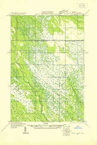
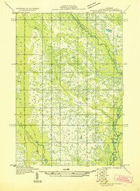 1931 Manistique River NE1931 Print · USGSSchoolcraft County’s hydrologic network is captured in the early 1930s as the U.S. Army Air Corps began utilizing aerial photography for land surveys. This sheet allows you to trace the intricate meanders of the Manistique River and Driggs River through Doyle and across vast Marsh lands.
 - 1931 Map of Seul Choix Point NW
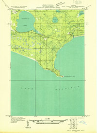 1931 Seul Choix Point NW1931 Print · USGSUpper Peninsula lakefront life is documented here in the early 1930s as the shoreline meets the northern woods. Genealogy researchers can locate the isolated Seul Choix School and Seul Choix Point Light or trace the early rail path of the Minn St Paul and Sault Ste Marie.
 - 1931 Map of Manistique River SE
 1931 Manistique River SE1931 Print · USGSThe northern Michigan wilderness of the early 1930s is revealed here through its complex river systems and isolated pioneer outposts. Genealogists can locate rural education centers like the Swede Settlement Sch and Wood Sch among the bends of the Manistique River.
 - 1931 Map of Blaney SW
 1931 Blaney SW1931 Print · USGSThe Upper Peninsula timber and rail landscape comes alive in this early 1930s survey of the Schoolcraft County interior. Researchers can trace the industrial footprint of the Lumber Co railroad, the Stone Quarry at Calaspar, and the New Blaney Fire Tower.
 - 1931 Map of Blaney NW
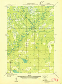
 1931 Blaney NW1931 Print · USGSThe Manistique River valley and the settlement of Germfask are captured here in the early 1930s as modern surveying first reached this watery landscape. Genealogists and local historians can trace rural landmarks like South School and named water bodies such as Mezik Lake and Chip Lake.
 - 1931 Map of Driggs Lake SE
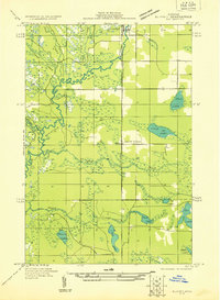
 1931 Driggs Lake SE1931 Print · USGSThe wetlands of the Seney area are captured here in the early 1930s, showing a landscape of remote camps and complex drainage. Genealogists and researchers can trace early transit routes like the Duluth South Shore and Atlantic railway and locate the isolated Cookson Camp.
End of results
Showing maps 1-7 of 7
Top cities near Doyle Township
Top neighborhoods of Doyle Township
Frequently asked questions
- What are the different types of historical maps available for Doyle Township?
- What is the oldest map of Doyle Township?
- Where can I purchase historical maps of Doyle Township for my home or office?
- Where can I download high-res historical maps of Doyle Township?
- Are there historical topographic maps available for Doyle Township?
- Is there historical aerial imagery available for Doyle Township?
- Where are historical maps of Doyle Township sourced from?