1940s Maps of Washtenaw County, Michigan
Explore 8 historic maps of Washtenaw County from the 1940s. These maps offer a rare glimpse into what life looked like during the 1940s — showing old roads, neighborhoods, homes, and landmarks that have changed or disappeared over time.
Whether you're researching your family's past, planning a metal detecting trip, or studying how Washtenaw County's landscape evolved across the 1940s, these high-resolution maps are a powerful tool for exploring the history of this region.
- Focus on a specific era: All maps on this page are from the 1940s, giving you a focused view of this time period.
- See what’s changed: Compare century-old streets, trails, and buildings to today's modern landscape using overlays and satellite layers.
- Research with precision: Use these maps for genealogy, historical research, land use analysis, or educational projects.
- View, download, or print: Maps are fully viewable online in high resolution, and can be downloaded or printed for your own records.
Start exploring Washtenaw County's history through authentic maps from the 1940s. This is your window into the past.
Washtenaw County, MI maps
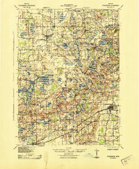
(8)- 1940 Map of Maybee
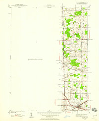 1940 Maybee1940 Print · USGSSoutheast Michigan's rural townships are documented here in the early 1940s as the railroad fueled local growth. You can trace early family homesteads near the Stony Creek Cem or locate old school sites like Clayton Sch and Columbia Sch.
 - 1942 Map of Ypsilanti East
 1942 Ypsilanti East1942 Print · USGSThe Washtenaw and Wayne County border comes alive in this early wartime survey, centered on the newly created Belleville Lake. Genealogists can locate family landmarks like the Soor Cem, Willow Run Sch, and the riverside settlement of Rawsonville.
 - 1942 Map of Maybee
 1942 Maybee1942 Print · USGSSoutheastern Michigan farmlands near the Monroe and Wayne county lines are documented here in the early 1940s. Genealogists can trace family landmarks like the Sandy Hill Cem and old school sites including Palmer Sch and Clayton Sch.
 - 1942 Map of Denton
 1942 Denton1942 Print · USGSThe rural borders of Washtenaw and Wayne Counties are captured here in the early 1940s, showing a landscape of family farms and emerging crossroads. Researchers can locate the Kenyon Cem, trace the Michigan Central tracks, and find old school sites like Hanford Sch and Palmer Sch.2 unique versions available
 - 1942 Map of Stockbridge, 1943 Print
 1942 Stockbridge1943 Print · USGSSouth-central Michigan during the early Forties is revealed here as a landscape of interconnected rail towns and scattered country schoolhouses. Genealogists can locate family landmarks like Livermore School, Mausbach School, and the remote Bullis Crossing Cem near the Grand Trunk line.
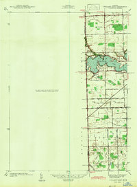
 - 1945 Map of Salem
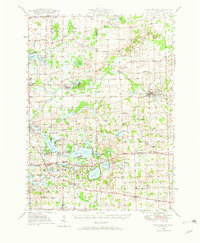
 1945 Salem1945 Print · USGSNorthwest of Detroit in the mid-1940s, this area shows a landscape transitioning between rural townships and large-scale institutions. Researchers can trace historic school sites like Putman Sch and the grounds of the Maybury Sanitarium.2 unique versions available
 - 1948 Map of Manchester, 1972 Print
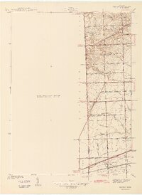
 1948 Manchester1972 Print · USGSManchester and the Irish Hills region are shown here just after the war, when the New York Central rail line still connected these rural townships. Genealogists can trace dozens of local schoolhouses and churches, such as Sharon Hill Sch and North Sharon Ch.2 unique versions available
 - 1949 Map of Manchester
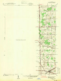
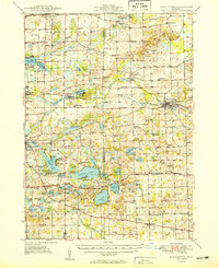 1949 Manchester1949 Print · USGSSoutheast Michigan in the late 1940s reveals a patchwork of small-town centers and lakeside retreats connected by the New York Central rail line. Genealogists can trace family roots through dozens of local sites like Raymond Cem, Iron Creek Ch, and the McMahon Sch.3 unique versions available
End of results
Showing maps 1-8 of 8
Top cities of Washtenaw County
- Ann Arbor historical maps
- Ypsilanti Charter Township historical maps
- Pittsfield Charter Township historical maps
- Ypsilanti historical maps
- Scio Township historical maps
- Superior Charter Township historical maps
See more
Frequently asked questions
- What are the different types of historical maps available for Washtenaw County?
- What is the oldest map of Washtenaw County?
- Where can I purchase historical maps of Washtenaw County for my home or office?
- Where can I download high-res historical maps of Washtenaw County?
- Are there historical topographic maps available for Washtenaw County?
- Is there historical aerial imagery available for Washtenaw County?
- Where are historical maps of Washtenaw County sourced from?