1950s Maps of Washtenaw County, Michigan
Explore 5 historic maps of Washtenaw County from the 1950s. These maps offer a rare glimpse into what life looked like during the 1950s — showing old roads, neighborhoods, homes, and landmarks that have changed or disappeared over time.
Whether you're researching your family's past, planning a metal detecting trip, or studying how Washtenaw County's landscape evolved across the 1950s, these high-resolution maps are a powerful tool for exploring the history of this region.
- Focus on a specific era: All maps on this page are from the 1950s, giving you a focused view of this time period.
- See what’s changed: Compare century-old streets, trails, and buildings to today's modern landscape using overlays and satellite layers.
- Research with precision: Use these maps for genealogy, historical research, land use analysis, or educational projects.
- View, download, or print: Maps are fully viewable online in high resolution, and can be downloaded or printed for your own records.
Start exploring Washtenaw County's history through authentic maps from the 1950s. This is your window into the past.
Washtenaw County, MI maps
(5)- 1953 Map of Ypsilanti East, 1955 Print
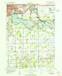 1953 Ypsilanti East1955 Print · USGSEastern Washtenaw County underwent significant industrial and aviation expansion in the 1950s, centered around the Huron River valley. Researchers can trace the development of the Willow Run Airport and locate local landmarks like the Friends Ch and Lincoln Sch.
 - 1953 Map of Denton, 1955 Print
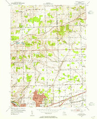 1953 Denton1955 Print · USGSWashtenaw County transitions from rural farmland to industrial suburban hubs during the mid-fifties. Genealogists and historians can trace the numerous local schoolhouses and rural crossroads, from Cherry Hill and Denton to the Leland Sanatorium.2 unique versions available
 - 1953 Map of Salem, 1955 Print
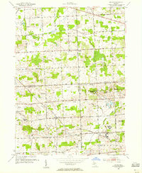 1953 Salem1955 Print · USGSSoutheast Michigan’s rural townships are captured here in the early 1950s as small farming communities began to interface with large county institutions. Researchers can trace family sites near Salem and Brookville, or locate landmarks like Thayer Cem and the Maybury Sanitarium.
 - 1954 Map of Detroit
 1954 Detroit1954 Print · USGSThe Detroit metro and its Ontario neighbors are shown at the height of the mid-century industrial era, just as the suburbs were rapidly expanding. Researchers can trace the massive rail networks of the Wabash Railroad or locate landmarks like Grosse Ile and Selfridge Air Force Base.
 - 1958 Map of Grand Rapids, 1973 Print
 1958 Grand Rapids1973 Print · USGSSouthern Michigan at the peak of the postwar era shows a landscape of burgeoning cities and new interstate highways. Trace family roots and regional growth in Grand Rapids, Battle Creek, and the glacial lake country around Gun Lake or Gull Lake.2 unique versions available
End of results
Showing maps 1-5 of 5
Top cities of Washtenaw County
- Ann Arbor historical maps
- Ypsilanti Charter Township historical maps
- Pittsfield Charter Township historical maps
- Ypsilanti historical maps
- Scio Township historical maps
- Superior Charter Township historical maps
See more
Frequently asked questions
- What are the different types of historical maps available for Washtenaw County?
- What is the oldest map of Washtenaw County?
- Where can I purchase historical maps of Washtenaw County for my home or office?
- Where can I download high-res historical maps of Washtenaw County?
- Are there historical topographic maps available for Washtenaw County?
- Is there historical aerial imagery available for Washtenaw County?
- Where are historical maps of Washtenaw County sourced from?