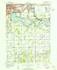
1953 Map of Ypsilanti East
USGS Topo · Published 1955About this map
The Huron River corridor anchors this mid-century survey, showcasing a landscape transformed by large-scale infrastructure and industrial development. Dominating the central area is the expansive Ford Lake, flanked by the early aviation facilities of Willow Run Airport and the Willow Run Expressway. The map reveals the eastern growth of Ypsilanti, characterized by established institutions like the Michigan State Normal College and the specialized campus of Edmonson Jr High Sch.
Find a feature on this map
52 named features on this map. Tap any name to fly to it.
Don’t see what you’re looking for? This feature index may not catch every label — zoom into the map to look around manually.
Map Details
Editions of this 1953 Ypsilanti East Map
This is the sole edition of this map. No revisions or reprints were ever made.
Other maps of this area

1902 · South Lyon
USGS Topo · 1:62,500

1902 · Ypsilanti
USGS Topo · 1:62,500

1904 · Ann Arbor
USGS Topo · 1:125,000

1905 · Wayne
USGS Topo · 1:62,500

1906 · Ypsilanti
USGS Topo · 1:62,500

1906 · South Lyon
USGS Topo · 1:62,500

1906 · Romulus
USGS Topo · 1:62,500

1908 · Ann Arbor
USGS Topo · 1:125,000

1912 · Wayne
USGS Topo · 1:62,500

1928 · Romulus
USGS Topo · 1:62,500
Featured Places
- Ypsilanti Charter Township, MI
- Van Buren Charter Township, MI
- Ypsilanti, MI
- Sumpter Township, MI
- Augusta Charter Township, MI