1930s Maps of Wayne County, Michigan
Explore 20 historic maps of Wayne County from the 1930s. These maps offer a rare glimpse into what life looked like during the 1930s — showing old roads, neighborhoods, homes, and landmarks that have changed or disappeared over time.
Whether you're researching your family's past, planning a metal detecting trip, or studying how Wayne County's landscape evolved across the 1930s, these high-resolution maps are a powerful tool for exploring the history of this region.
- Focus on a specific era: All maps on this page are from the 1930s, giving you a focused view of this time period.
- See what’s changed: Compare century-old streets, trails, and buildings to today's modern landscape using overlays and satellite layers.
- Research with precision: Use these maps for genealogy, historical research, land use analysis, or educational projects.
- View, download, or print: Maps are fully viewable online in high resolution, and can be downloaded or printed for your own records.
Start exploring Wayne County's history through authentic maps from the 1930s. This is your window into the past.
Wayne County, MI maps
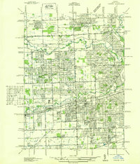
(20)- 1934 Map of Detroit
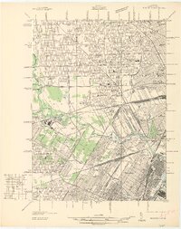
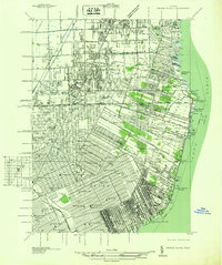
 1934 Detroit1934 Print · USGSThe Detroit riverfront and its rising industrial suburbs are captured here during the peak of the automotive boom. Genealogists and historians can trace the early footprints of the Ford Motor Co and local landmarks like Olivet Cemetery or the State Fair Grounds.
 - 1936 Map of Inkster
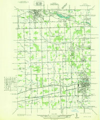
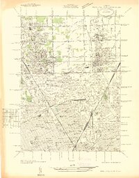
 1936 Inkster1936 Print · USGSWestern Wayne County was a landscape of institutions and early aviation in the years before the war. Researchers can trace the legacy of the Eloise Hospital and Infirmary, locate local landmarks like Wankin Mills, or find family roots near Perrinsville and St Marys Cem.
 - 1936 Map of Wayne
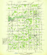
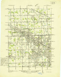
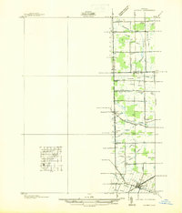
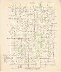
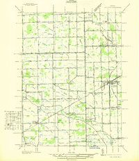
 1936 Wayne1936 Print · USGSWestern Wayne County is seen here during the mid-1930s, showing the early suburban development between Plymouth and Wayne. Researchers can trace old property contexts and local landmarks like the Triangle Airport, Cadillac Mem Park Cem, and numerous country schools including Washington Sch.
 - 1936 Map of Wyandotte
 1936 Wyandotte1936 Print · USGSThe industrial corridor south of Detroit is captured here in the mid-1930s as manufacturing and residential grids expanded toward the river. Trace the development of local neighborhoods and landmarks like the Sibley Quarry, Sacred Heart Cem, and the Thorofare Canal on Grosse Ile.
 - 1936 Map of Belleville
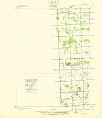
 1936 Belleville1936 Print · USGSWestern Wayne County is seen here in the mid-1930s, showing a landscape defined by the Huron River and a burgeoning network of roads and rail. Researchers can locate old family plots and rural institutions like Martinsville Cem, Mt Pleasant Sch, and the Tyler Rd Community Hall.
 - 1936 Map of Denton
 1936 Denton1936 Print · USGSThe borderlands of Washtenaw and Wayne counties come into focus during the mid-1930s, showing a landscape of small schools and intricate creek systems. Genealogists can locate family landmarks like Kinyon Cem and trace the paths of the Michigan Central Railroad through Denton.
 - 1936 Map of Rockwood
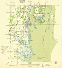 1936 Rockwood1936 Print · USGSCoastal Wayne County and the Detroit River islands are shown here in the mid-thirties, just as the aviation and shipping industries were maturing. Researchers can locate the U S Naval Reserve Aviation Base on Grosse Ile, the St Marys Cem, and the marshy expanses around Point Mouillee.
 - 1936 Map of Redford
 1936 Redford1936 Print · USGSNorthwestern Detroit suburbs emerge from farm tracts during the mid-1930s, showing early neighborhoods and grid-road expansion. Genealogists can find numerous burial grounds like Grand Lawn Cem and landmarks such as Bell Br Community Ch and the Redford Post Office.
 - 1936 Map of Flat Rock
 1936 Flat Rock1936 Print · USGSSoutheast Michigan's riverfront and rail corridors are captured here in the mid-1930s as industrial yards and rural townships began to interface. Researchers can trace ancestral roots through dozens of local landmarks including Ash Center Cem, Maple Grove Sch, and the unique settlement at Scrabble.
 - 1936 Map of Highland Park
 1936 Highland Park1936 Print · USGSGreater Detroit and the enclaves of Highland Park and Hamtramck are captured here in the mid-1930s as urban growth pushes north. Researchers can pinpoint early neighborhoods, local schools like Henry Ford Sch, and the grounds of the Michigan State Fair.
 - 1936 Map of Dearborn
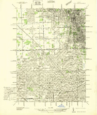
 1936 Dearborn1936 Print · USGSMid-century Dearborn and West Detroit are captured in 1936, showing a landscape defined by the rise of the automotive industry. Genealogists and historians can locate early neighborhood schools like Mackenzie HS and landmark sites like Ford Airport and Greenfield Village.
 - 1936 Map of Maybee
 1936 Maybee1936 Print · USGSThe Monroe and Wayne County borderlands are captured here in the mid-1930s, showing a rural landscape defined by rail and drainage. Trace the Detroit Toledo & Ironton RR through Maybee or locate family sites like Palmer Sch and Sandy Hill Cem.
 - 1936 Map of Salem
 1936 Salem1936 Print · USGSNorthwestern Wayne County and southern Oakland County are captured in the mid-1930s before postwar suburbanization. Genealogists and local researchers can trace old family section lines and find landmark institutions like the Maybury Sanitarium and West Novi Sch.
 - 1936 Map of Grosse Pointe
 1936 Grosse Pointe1936 Print · USGSThe Detroit lakeshore and its rising suburbs are captured here in the mid-1930s, showing a landscape of yacht clubs, golf courses, and dense street grids. Trace the growth of Grosse Pointe Shores and Roseville or locate landmarks like Jefferson Beach and the Erin Cem.
 - 1936 Map of Wayne Co Airport
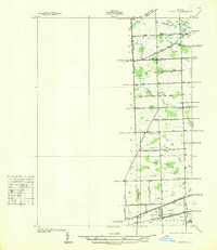
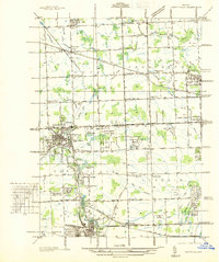
 1936 Wayne Co Airport1936 Print · USGSWayne County was evolving from a rural landscape of family farms to an aviation hub in the mid-1930s. Researchers can trace early schools and cemeteries like Hale Sch, Tryskett Sch, and West Mound Cem alongside the Wayne County Airport.
 - 1936 Map of Northville
 1936 Northville1936 Print · USGSNorthwest Wayne and southwest Oakland counties are captured here in the mid-1930s as the grid of mile roads and institutions matured. Researchers can trace family history at Rural Hill Cem or explore early landmarks like the US Fish Hatchery and Wayne County Training Sch.
 - 1936 Map of Ypsilanti East
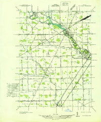
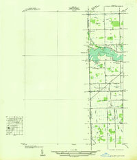 1936 Ypsilanti East1936 Print · USGSThe Washtenaw and Wayne County line in the mid-1930s is defined by the winding waters of Belleville Lake and a complex system of agricultural drains. Genealogists and local historians can locate early landmarks like Soop Cem, Willow Run Sch, and the settlement at Rawsonville.
 - 1936 Map of Carleton
 1936 Carleton1936 Print · USGSSoutheast Michigan farm country is captured here during the mid-thirties, showing the rural landscape surrounding the village of Carleton. Researchers can trace old family schoolhouses like Long Bridge Sch and early church sites including St Johns Ch along the Pere Marquette line.
 - 1936 Map of Royal Oak
 1936 Royal Oak1936 Print · USGSOakland County was rapidly developing north of Detroit during the mid-1930s, as residential grids expanded over former farmland. Genealogists can locate family homes near Southfield Ch or trace the early layout of Lathrup and Huntington Woods.
 - 1937 Map of Detroit
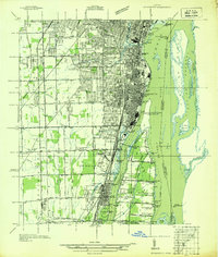
 1937 Detroit1937 Print · USGSDetroit at the peak of its industrial era shows a bustling riverfront and a dense grid of neighborhoods just before the war. Researchers can trace the rail-and-water economy through the Union Depot, Zug Island, and the international Ambassador Bridge.
End of results
Showing maps 1-20 of 20
Top cities of Wayne County
- Detroit historical maps
- Canton Township historical maps
- Livonia historical maps
- Dearborn historical maps
- Westland historical maps
- Taylor historical maps
See more
Frequently asked questions
- What are the different types of historical maps available for Wayne County?
- What is the oldest map of Wayne County?
- Where can I purchase historical maps of Wayne County for my home or office?
- Where can I download high-res historical maps of Wayne County?
- Are there historical topographic maps available for Wayne County?
- Is there historical aerial imagery available for Wayne County?
- Where are historical maps of Wayne County sourced from?