1940s Maps of Wayne County, Michigan
Explore 22 historic maps of Wayne County from the 1940s. These maps offer a rare glimpse into what life looked like during the 1940s — showing old roads, neighborhoods, homes, and landmarks that have changed or disappeared over time.
Whether you're researching your family's past, planning a metal detecting trip, or studying how Wayne County's landscape evolved across the 1940s, these high-resolution maps are a powerful tool for exploring the history of this region.
- Focus on a specific era: All maps on this page are from the 1940s, giving you a focused view of this time period.
- See what’s changed: Compare century-old streets, trails, and buildings to today's modern landscape using overlays and satellite layers.
- Research with precision: Use these maps for genealogy, historical research, land use analysis, or educational projects.
- View, download, or print: Maps are fully viewable online in high resolution, and can be downloaded or printed for your own records.
Start exploring Wayne County's history through authentic maps from the 1940s. This is your window into the past.
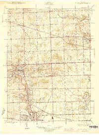
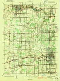
Wayne County, MI maps
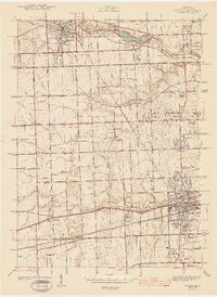
(22)- 1940 Map of Highland Park
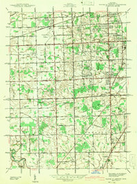
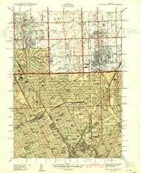 1940 Highland Park1940 Print · USGSGreater Detroit was expanding rapidly just before the war, as residential grids replaced the agricultural lands of southern Macomb and Oakland Counties. Genealogists and historians can locate family landmarks like the Michigan State Fair Grounds and St Clements Cem.2 unique versions available
 - 1940 Map of Grosse Pointe
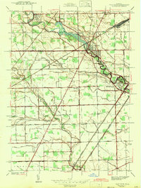
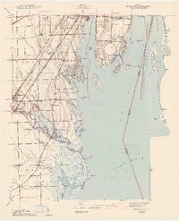
 1940 Grosse Pointe1940 Print · USGSCoastal Wayne County and the rising Detroit suburbs are captured here just before the war. Researchers can trace the development of the Pointes and find family landmarks like St Peters Ch, Jefferson Beach, and Gratiot Airport.
 - 1940 Map of Detroit
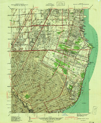
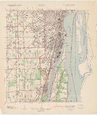
 1940 Detroit1940 Print · USGSDetroit and its Canadian neighbors thrive as a unified industrial corridor during the late thirties. Researchers can trace the massive rail-and-river network through the Detroit-Windsor Tunnel, Union Depot, and industrial sites like Zug Island.
 - 1940 Map of Maybee
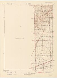
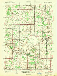
 1940 Maybee1940 Print · USGSSoutheast Michigan's rural townships are documented here in the early 1940s as the railroad fueled local growth. You can trace early family homesteads near the Stony Creek Cem or locate old school sites like Clayton Sch and Columbia Sch.
 - 1941 Map of Royal Oak
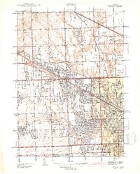
 1941 Royal Oak1941 Print · USGSThe Detroit and Oakland County borderlands come into sharp focus in the late thirties as suburban neighborhoods began to fill the grid. Genealogists and local researchers can trace early residential blocks, parish schools like Gesu Sch, and prominent landmarks including the Detroit Zoological Park and Oakview Cem.2 unique versions available
 - 1942 Map of Wayne Co Airport
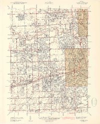
 1942 Wayne Co Airport1942 Print · USGSWayne County during the early years of the war shows a landscape balancing its rural roots with new aviation infrastructure. Genealogists and historians can trace dozens of family-named drainage systems and rural institutions like Eureka Belt Sch and West Mound Cem.
 - 1942 Map of Flat Rock
 1942 Flat Rock1942 Print · USGSThe Detroit-Toledo corridor comes into focus just before the mid-century, where the Huron River meets a network of major railroads and early highways. Genealogists and local historians can trace rural schoolhouses like Bancroft Sch and Peters Sch, or locate family plots within Riverside Cem and Oakwood Cem.2 unique versions available
 - 1942 Map of Ypsilanti East
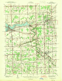
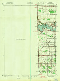 1942 Ypsilanti East1942 Print · USGSThe Washtenaw and Wayne County border comes alive in this early wartime survey, centered on the newly created Belleville Lake. Genealogists can locate family landmarks like the Soor Cem, Willow Run Sch, and the riverside settlement of Rawsonville.
 - 1942 Map of Maybee
 1942 Maybee1942 Print · USGSSoutheastern Michigan farmlands near the Monroe and Wayne county lines are documented here in the early 1940s. Genealogists can trace family landmarks like the Sandy Hill Cem and old school sites including Palmer Sch and Clayton Sch.
 - 1942 Map of Rockwood
 1942 Rockwood1942 Print · USGSThe Downriver shoreline and Grosse Ile appear here in the early 1940s as the region's shipping and rail networks expanded. Genealogists and historians can trace local landmarks like St Marys Cem, the Powderhouse, and small settlements such as Milleville Beach.2 unique versions available
 - 1942 Map of Denton
 1942 Denton1942 Print · USGSThe rural borders of Washtenaw and Wayne Counties are captured here in the early 1940s, showing a landscape of family farms and emerging crossroads. Researchers can locate the Kenyon Cem, trace the Michigan Central tracks, and find old school sites like Hanford Sch and Palmer Sch.2 unique versions available
 - 1942 Map of Redford
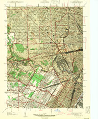
 1942 Redford1942 Print · USGSNorthwest of Detroit during the early war years, this survey captures the transition from township farmsteads to suburban hubs. Trace family roots and local landmarks through sites like the Redford PO, Burns Airport, and Grand Lawn Cem.2 unique versions available
 - 1942 Map of Dearborn
 1942 Dearborn1942 Print · USGSDearborn and the industrial Detroit fringe are captured here at the height of the early war years. Genealogists and historians can trace dozens of neighborhoods and schools, from Fordson High Sch to the grounds of Greenfield Village and Camp Legion.2 unique versions available
 - 1942 Map of Carleton
 1942 Carleton1942 Print · USGSMonroe and Wayne counties come into focus during the early 1940s, showing a landscape shaped by rail-line junctions and agricultural drains. Genealogists can trace family names through landmarks like Felt Cem, St Patricks Cem, and local schoolhouses like Willow Sch or Long Bridge Sch.2 unique versions available
 - 1942 Map of Belleville
 1942 Belleville1942 Print · USGSIn the early 1940s, western Wayne County remained a landscape of river-fed townships and railroad hamlets. Local historians can trace early community hubs like French Landing and Martinsville or locate family sites near St Stephens Cem.
 - 1942 Map of Wyandotte
 1942 Wyandotte1942 Print · USGSThe Detroit River industrial corridor is shown in detail during the early 1940s, from the city of Wyandotte south to Trenton. Genealogists and historians can trace family-named sites and vanished landmarks like Goddard Farms, the Sibley Quarry, and Heintzen Sch.2 unique versions available
 - 1942 Map of Inkster
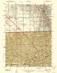
 1942 Inkster1942 Print · USGSWayne County at the onset of the 1940s shows a landscape of growing suburbs and vital transit hubs. Genealogists and local historians can trace the foundations of Garden City and Inkster or locate landmarks like Eloise Hospital and Nankin Mills.2 unique versions available
 - 1943 Map of Wayne
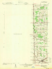
 1943 Wayne1943 Print · USGSWestern Wayne County is shown here during the early forties, capturing the landscape before intensive suburban growth reached the area. Genealogists and local historians can trace family-named landmarks like Chubb Cem, Truesdell Sch, and the small settlement of Sheldon.
 - 1945 Map of Northville
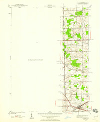
 1945 Northville1945 Print · USGSThe border of Wayne and Oakland counties in the mid-1940s reveals a landscape of expanding townships and established institutions. Genealogists and historians can trace family locations near Glen Eden Cem, Waterford Sch, and the Pere Marquette rail line.2 unique versions available
 - 1945 Map of Salem
 1945 Salem1945 Print · USGSNorthwest of Detroit in the mid-1940s, this area shows a landscape transitioning between rural townships and large-scale institutions. Researchers can trace historic school sites like Putman Sch and the grounds of the Maybury Sanitarium.2 unique versions available
 - 1947 Map of Detroit
 1947 Detroit1947 Print · USGSPost-war Detroit and its Ontario neighbors are shown in meticulous detail during the city's industrial peak. Researchers can trace the mid-century urban fabric through dozens of local landmarks like Briggs Stadium, the Ambassador Bridge, and Wayne University.
 - 1948 Map of Wayne
 1948 Wayne1948 Print · USGSWestern Wayne County was a landscape of transit and township life during the 1940s, balancing growing towns with extensive farm drainage systems. Genealogists can locate family landmarks like Sheldon Cem and Truesdell Sch or trace early aviation at Triangle Airport.
End of results
Showing maps 1-22 of 22
Top cities of Wayne County
- Detroit historical maps
- Canton Township historical maps
- Livonia historical maps
- Dearborn historical maps
- Westland historical maps
- Taylor historical maps
See more
Frequently asked questions
- What are the different types of historical maps available for Wayne County?
- What is the oldest map of Wayne County?
- Where can I purchase historical maps of Wayne County for my home or office?
- Where can I download high-res historical maps of Wayne County?
- Are there historical topographic maps available for Wayne County?
- Is there historical aerial imagery available for Wayne County?
- Where are historical maps of Wayne County sourced from?