Old Maps of Wayne County, Michigan for Academic Research
Study the evolution of Wayne County with 222 high-resolution historic maps. Whether you're teaching, researching, or modeling changes in land use, these maps provide essential visual documentation of urban, environmental, and geographic change.
- Analyze long-term change: Track patterns in development, transportation, and natural features.
- Ideal for environmental or urban studies: Support academic projects with primary historical map data.
- Use in the classroom or lab: Educators and researchers rely on these maps to bring historical context to life.
These maps are a powerful tool for teaching, research, and visualizing how Wayne County has changed over the decades.
Wayne County, MI maps
(222)- 1902 Map of South Lyon, 1954 Print
 1902 South Lyon1954 Print · USGSSoutheast Michigan at the turn of the century reveals a landscape of thriving rail junctions and rural townships across Oakland and Washtenaw counties. Trace the early footprints of Ann Arbor and South Lyon alongside historic whistle-stops like Emery and Geddes.
 - 1902 Map of Ypsilanti, 1958 Print
 1902 Ypsilanti1958 Print · USGSSoutheast Michigan at the turn of the century shows a landscape defined by thriving rail towns and winding river valleys. Genealogists and historians can trace the early footprints of Ypsilanti or find smaller locales like Rawsonville and Azalia along the Huron River and Michigan Central RR.
 - 1904 Map of Ann Arbor
 1904 Ann Arbor1904 Print · USGSEarly twentieth-century Washtenaw County comes to life through its dense network of interurban electric lines and steam railroads. Researchers can trace the layout of Ann Arbor, locate the Duck Lake School, or find vanished stops along the Michigan Central R. R. and Ann Arbor R. R..2 unique versions available
 - 1905 Map of Wayne
 1905 Wayne1905 Print · USGSWestern Wayne and southern Oakland counties are seen here at a pivotal moment when electric interurban railways first linked rural townships. Genealogists can trace family footprints in Northville, Plymouth, and Farmington, or locate vanished landmarks like Perrinville and the Wayne County Home.4 unique versions available
 - 1905 Map of Detroit
 1905 Detroit1905 Print · USGSDetroit and its surrounding townships are shown at a pivotal moment of expansion during the early 1900s. Genealogists and historians can trace the development of early suburbs like Highland Park and Royal Oak along major transit arteries like Grand River Ave. and the numerous electric railways.2 unique versions available
 - 1905 Map of Grosse Pointe
 1905 Grosse Pointe1905 Print · USGSCoastal Wayne County at the turn of the century shows an era of transit-driven growth along Lake St Clair. Researchers can trace the early layout of Grosse Pointe Shores, the grounds of Belle Isle Park, and the route of the Grand Trunk R R.4 unique versions available
 - 1906 Map of Ypsilanti
 1906 Ypsilanti1906 Print · USGSSoutheast Michigan at the dawn of the century reveals a landscape defined by its bustling river towns and burgeoning rail networks. Trace the early development of Ypsilanti and Milan or locate vanished stops along the Michigan Central RR and the Wabash RR.3 unique versions available
 - 1906 Map of Wyandotte
 1906 Wyandotte1906 Print · USGSThe Detroit River shoreline and its industrial borderlands are captured here at the height of the electric railway era. Genealogists and historians can trace the early footprints of Wyandotte, the development of Grosse Isle, and the complex rail networks of the M C R R.2 unique versions available
 - 1906 Map of South Lyon
 1906 South Lyon1906 Print · USGSSoutheast Michigan at the turn of the century shows a landscape defined by an intricate web of steam and electric railways. Researchers can trace the early layouts of Ann Arbor and South Lyon, or locate smaller depots like Whitmore Lake Station and Rushton.5 unique versions available
 - 1906 Map of Romulus
 1906 Romulus1906 Print · USGSSoutheast Michigan at the turn of the century shows a landscape defined by the winding Huron River and a dense network of competing steam and electric railways. Genealogists can trace early homesteads and rail stops in settlements like New Boston, Waltz, and the early crossroads at Carleton.2 unique versions available
 - 1908 Map of Ann Arbor
 1908 Ann Arbor1908 Print · USGSSoutheast Michigan at the turn of the century shows a landscape transitioning through the arrival of electric rail and the growth of the Huron River valley. Genealogists and researchers can trace old family lands near Saline, Ypsilanti, and Whitmore Lake, or follow the path of the Michigan Central RR.
 - 1912 Map of Wyandotte
 1912 Wyandotte1912 Print · USGSThe industrial corridor south of Detroit thrives along the river just before the Great War. Genealogists and historians can trace the early rail networks of the Michigan Central RR and find specific river landmarks like Grosse Isle and Gibraltar.
 - 1912 Map of Wayne
 1912 Wayne1912 Print · USGSWestern Wayne County in the early twentieth century shows a landscape being reshaped by the first concrete roads and a dense network of electric interurban railways. Trace the early development of Livonia, Redford, and Plymouth, or locate long-standing sites like Eloise and Perrinville.
 - 1918 Map of Detroit
 1918 Detroit1918 Print · USGSDetroit and its surrounding townships appear at the height of the early industrial era, captured just after the close of the Great War. Local researchers can trace the growth of the Ford Motor Co. empire near Navarre P.O. and explore the historic rail corridors of Hamtramck and Royal Oak.
 - 1918 Map of Grosse Pointe
 1918 Grosse Pointe1918 Print · USGSThe Lake St. Clair shoreline comes alive in this late-era survey of Wayne and Macomb counties, showing the region just as the Grosse Pointes were formalizing. Trace early electric transit via the Detroit and Port Huron Electric Line and locate vanished stops at Labadies or Claireview.
 - 1924 Map of Detroit
 1924 Detroit1924 Print · USGSDetroit and its industrial satellites thrive during the peak of the automotive era. Genealogists and historians can trace the early factory footprints of Dodge Bros. or locate old neighborhood landmarks like Navarre P. O. and Mt. Olivet Cemetery.
 - 1928 Map of Romulus
 1928 Romulus1928 Print · USGSSoutheast Michigan at the height of its rail-and-river era shows a dense network of transit lines and river towns. Genealogists can trace family roots through settlements like French Landing, Waltz, and South Rockwood or follow the path of the Pere Marquette RR.
 - 1929 Map of Wyandotte
 1929 Wyandotte1929 Print · USGSThe Detroit River shoreline comes alive in this late 1920s survey of the industrial corridor south of the city. Genealogists and historians can trace the early grids of Wyandotte and Amherstburg, or locate riverfront landmarks like Grosse Isle and Slocum Junc.
 - 1934 Map of Detroit
 1934 Detroit1934 Print · USGSThe Detroit riverfront and its rising industrial suburbs are captured here during the peak of the automotive boom. Genealogists and historians can trace the early footprints of the Ford Motor Co and local landmarks like Olivet Cemetery or the State Fair Grounds.
 - 1936 Map of Inkster
 1936 Inkster1936 Print · USGSWestern Wayne County was a landscape of institutions and early aviation in the years before the war. Researchers can trace the legacy of the Eloise Hospital and Infirmary, locate local landmarks like Wankin Mills, or find family roots near Perrinsville and St Marys Cem.
 - 1936 Map of Wayne
 1936 Wayne1936 Print · USGSWestern Wayne County is seen here during the mid-1930s, showing the early suburban development between Plymouth and Wayne. Researchers can trace old property contexts and local landmarks like the Triangle Airport, Cadillac Mem Park Cem, and numerous country schools including Washington Sch.
 - 1936 Map of Wyandotte
 1936 Wyandotte1936 Print · USGSThe industrial corridor south of Detroit is captured here in the mid-1930s as manufacturing and residential grids expanded toward the river. Trace the development of local neighborhoods and landmarks like the Sibley Quarry, Sacred Heart Cem, and the Thorofare Canal on Grosse Ile.
 - 1936 Map of Belleville
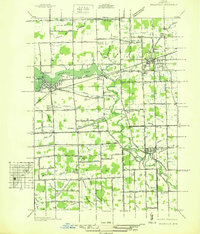 1936 Belleville1936 Print · USGSWestern Wayne County is seen here in the mid-1930s, showing a landscape defined by the Huron River and a burgeoning network of roads and rail. Researchers can locate old family plots and rural institutions like Martinsville Cem, Mt Pleasant Sch, and the Tyler Rd Community Hall.
 - 1936 Map of Denton
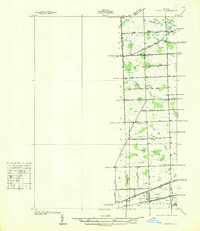 1936 Denton1936 Print · USGSThe borderlands of Washtenaw and Wayne counties come into focus during the mid-1930s, showing a landscape of small schools and intricate creek systems. Genealogists can locate family landmarks like Kinyon Cem and trace the paths of the Michigan Central Railroad through Denton.
 - 1936 Map of Rockwood
 1936 Rockwood1936 Print · USGSCoastal Wayne County and the Detroit River islands are shown here in the mid-thirties, just as the aviation and shipping industries were maturing. Researchers can locate the U S Naval Reserve Aviation Base on Grosse Ile, the St Marys Cem, and the marshy expanses around Point Mouillee.
Showing maps 1-25 of 222
Top cities of Wayne County
- Detroit historical maps
- Canton Township historical maps
- Livonia historical maps
- Dearborn historical maps
- Westland historical maps
- Taylor historical maps
See more
Frequently asked questions
- What are the different types of historical maps available for Wayne County?
- What is the oldest map of Wayne County?
- Where can I purchase historical maps of Wayne County for my home or office?
- Where can I download high-res historical maps of Wayne County?
- Are there historical topographic maps available for Wayne County?
- Is there historical aerial imagery available for Wayne County?
- Where are historical maps of Wayne County sourced from?