Old Maps of Plymouth Charter Township, Michigan for Genealogy
Trace your family roots with 48 historic maps of Plymouth Charter Township. These high-res maps reveal old neighborhoods, homesites, landmarks, and streets — helping you uncover where your ancestors lived and how the area evolved over time.
- Explore historic neighborhoods: Identify where your relatives may have lived in the 1800s or 1900s.
- Compare maps over time: Trace the changes in streets, buildings, and landmarks for multi-generational research.
- Perfect for genealogy & ancestry research: Used by family historians and researchers to map out lineage and migration.
These maps are an incredible resource for exploring your personal connection to Plymouth Charter Township's past.
Plymouth Charter Township, MI maps
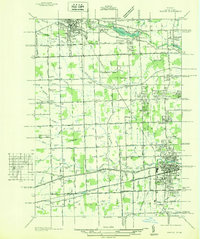
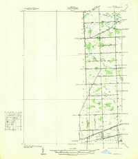
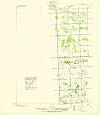
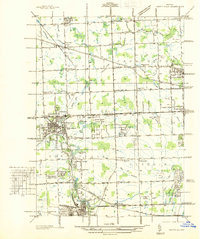
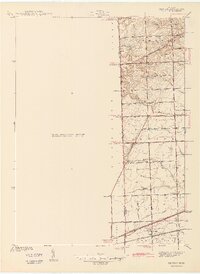
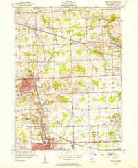
(48)- 1902 Map of South Lyon, 1954 Print
 1902 South Lyon1954 Print · USGSSoutheast Michigan at the turn of the century reveals a landscape of thriving rail junctions and rural townships across Oakland and Washtenaw counties. Trace the early footprints of Ann Arbor and South Lyon alongside historic whistle-stops like Emery and Geddes.
 - 1904 Map of Ann Arbor
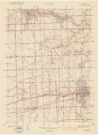
 1904 Ann Arbor1904 Print · USGSEarly twentieth-century Washtenaw County comes to life through its dense network of interurban electric lines and steam railroads. Researchers can trace the layout of Ann Arbor, locate the Duck Lake School, or find vanished stops along the Michigan Central R. R. and Ann Arbor R. R..2 unique versions available
 - 1905 Map of Wayne
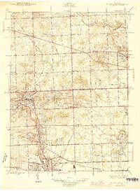
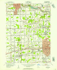
 1905 Wayne1905 Print · USGSWestern Wayne and southern Oakland counties are seen here at a pivotal moment when electric interurban railways first linked rural townships. Genealogists can trace family footprints in Northville, Plymouth, and Farmington, or locate vanished landmarks like Perrinville and the Wayne County Home.4 unique versions available
 - 1906 Map of South Lyon
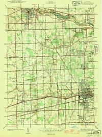
 1906 South Lyon1906 Print · USGSSoutheast Michigan at the turn of the century shows a landscape defined by an intricate web of steam and electric railways. Researchers can trace the early layouts of Ann Arbor and South Lyon, or locate smaller depots like Whitmore Lake Station and Rushton.5 unique versions available
 - 1908 Map of Ann Arbor
 1908 Ann Arbor1908 Print · USGSSoutheast Michigan at the turn of the century shows a landscape transitioning through the arrival of electric rail and the growth of the Huron River valley. Genealogists and researchers can trace old family lands near Saline, Ypsilanti, and Whitmore Lake, or follow the path of the Michigan Central RR.
 - 1912 Map of Wayne
 1912 Wayne1912 Print · USGSWestern Wayne County in the early twentieth century shows a landscape being reshaped by the first concrete roads and a dense network of electric interurban railways. Trace the early development of Livonia, Redford, and Plymouth, or locate long-standing sites like Eloise and Perrinville.
 - 1936 Map of Wayne
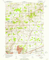
 1936 Wayne1936 Print · USGSWestern Wayne County is seen here during the mid-1930s, showing the early suburban development between Plymouth and Wayne. Researchers can trace old property contexts and local landmarks like the Triangle Airport, Cadillac Mem Park Cem, and numerous country schools including Washington Sch.
 - 1936 Map of Denton
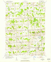
 1936 Denton1936 Print · USGSThe borderlands of Washtenaw and Wayne counties come into focus during the mid-1930s, showing a landscape of small schools and intricate creek systems. Genealogists can locate family landmarks like Kinyon Cem and trace the paths of the Michigan Central Railroad through Denton.
 - 1936 Map of Salem
 1936 Salem1936 Print · USGSNorthwestern Wayne County and southern Oakland County are captured in the mid-1930s before postwar suburbanization. Genealogists and local researchers can trace old family section lines and find landmark institutions like the Maybury Sanitarium and West Novi Sch.
 - 1936 Map of Northville
 1936 Northville1936 Print · USGSNorthwest Wayne and southwest Oakland counties are captured here in the mid-1930s as the grid of mile roads and institutions matured. Researchers can trace family history at Rural Hill Cem or explore early landmarks like the US Fish Hatchery and Wayne County Training Sch.
 - 1942 Map of Denton
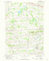
 1942 Denton1942 Print · USGSThe rural borders of Washtenaw and Wayne Counties are captured here in the early 1940s, showing a landscape of family farms and emerging crossroads. Researchers can locate the Kenyon Cem, trace the Michigan Central tracks, and find old school sites like Hanford Sch and Palmer Sch.2 unique versions available
 - 1943 Map of Wayne
 1943 Wayne1943 Print · USGSWestern Wayne County is shown here during the early forties, capturing the landscape before intensive suburban growth reached the area. Genealogists and local historians can trace family-named landmarks like Chubb Cem, Truesdell Sch, and the small settlement of Sheldon.
 - 1945 Map of Northville
 1945 Northville1945 Print · USGSThe border of Wayne and Oakland counties in the mid-1940s reveals a landscape of expanding townships and established institutions. Genealogists and historians can trace family locations near Glen Eden Cem, Waterford Sch, and the Pere Marquette rail line.2 unique versions available
 - 1945 Map of Salem
 1945 Salem1945 Print · USGSNorthwest of Detroit in the mid-1940s, this area shows a landscape transitioning between rural townships and large-scale institutions. Researchers can trace historic school sites like Putman Sch and the grounds of the Maybury Sanitarium.2 unique versions available
 - 1948 Map of Wayne
 1948 Wayne1948 Print · USGSWestern Wayne County was a landscape of transit and township life during the 1940s, balancing growing towns with extensive farm drainage systems. Genealogists can locate family landmarks like Sheldon Cem and Truesdell Sch or trace early aviation at Triangle Airport.
 - 1952 Map of Northville, 1954 Print
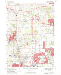
 1952 Northville1954 Print · USGSThe settlement of Novi is shown at a pivotal moment in the early fifties before the rapid growth of the Detroit suburbs. Genealogists and local historians can trace the historical layout and early road systems centered around Novi.2 unique versions available
 - 1952 Map of Wayne, 1954 Print
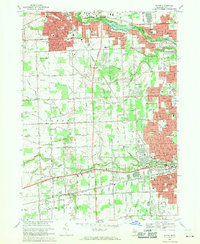
 1952 Wayne1954 Print · USGSWestern Wayne County underwent a massive suburban transformation in the early fifties as Detroit's residential grid pushed westward. Researchers can trace the development of Norwayne, find family plots in Sheldon Cem, or locate historic flight paths at Mettetal Airport.2 unique versions available
 - 1953 Map of Denton, 1955 Print
 1953 Denton1955 Print · USGSWashtenaw County transitions from rural farmland to industrial suburban hubs during the mid-fifties. Genealogists and historians can trace the numerous local schoolhouses and rural crossroads, from Cherry Hill and Denton to the Leland Sanatorium.2 unique versions available
 - 1953 Map of Salem, 1955 Print
 1953 Salem1955 Print · USGSSoutheast Michigan’s rural townships are captured here in the early 1950s as small farming communities began to interface with large county institutions. Researchers can trace family sites near Salem and Brookville, or locate landmarks like Thayer Cem and the Maybury Sanitarium.
 - 1954 Map of Detroit
 1954 Detroit1954 Print · USGSThe Detroit metro and its Ontario neighbors are shown at the height of the mid-century industrial era, just as the suburbs were rapidly expanding. Researchers can trace the massive rail networks of the Wabash Railroad or locate landmarks like Grosse Ile and Selfridge Air Force Base.
 - 1961 Map of Detroit, 1973 Print
 1961 Detroit1973 Print · USGSThe international border between Michigan and Ontario was a bustling industrial corridor in the early sixties. Researchers can trace the transit networks and riverfront infrastructure connecting Detroit to Windsor via the Detroit-Windsor Tunnel and major air hubs like Willow Run Airport.2 unique versions available
 - 1965 Map of Detroit
 1965 Detroit1965 Print · USGSThe industrial corridor between Michigan and Ontario is captured here at mid-century, showing the dense rail and river networks of the Great Lakes. Local historians can trace the paths of the Grand Trunk Western RR and locate key landmarks like Selfridge Air Force Base and Grosse Ile.
 - 1968 Map of Wayne, 1970 Print
 1968 Wayne1970 Print · USGSWayne County saw rapid suburban transformation in the late sixties as the landscapes of Plymouth, Westland, and Livonia converged. Genealogists and local historians can trace family-named drains and landmarks like Riverside Cemetery, the Mettetal Airport, and the Penn Central rail lines.4 unique versions available
 - 1969 Map of Northville, 1971 Print
 1969 Northville1971 Print · USGSThe Northville and Farmington area is captured here at a moment of intense postwar expansion and institutional development. Genealogists and researchers can trace the grounds of the Northville State Hospital, find family plots in Quaker Cem, and locate long-standing landmarks like Northville Downs.4 unique versions available
 - 1969 Map of Salem, 1971 Print
 1969 Salem1971 Print · USGSSoutheast Michigan in the late sixties reveals a landscape of institutional campuses and family farms at the junction of three counties. Genealogists and historians can trace Salem and Brookville or locate the Detroit House of Correction and Maybury Sanitarium.5 unique versions available
Showing maps 1-25 of 48
Top cities near Plymouth Charter Township
- Detroit historical maps
- Ann Arbor historical maps
- Canton Township historical maps
- Canton Charter Township historical maps
- Livonia historical maps
- Dearborn historical maps
See more
Frequently asked questions
- What are the different types of historical maps available for Plymouth Charter Township?
- What is the oldest map of Plymouth Charter Township?
- Where can I purchase historical maps of Plymouth Charter Township for my home or office?
- Where can I download high-res historical maps of Plymouth Charter Township?
- Are there historical topographic maps available for Plymouth Charter Township?
- Is there historical aerial imagery available for Plymouth Charter Township?
- Where are historical maps of Plymouth Charter Township sourced from?