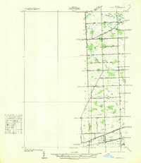
1936 Map of Denton
USGS Topo · Published 1936About this map
Denton and Cherry Hill anchor this rural landscape along the boundary between Washtenaw and Wayne counties during the mid-1930s. The region is defined by a dense network of agricultural drainage and small waterways, including Fellows Creek and the Lower River Rouge, which supported the surrounding farmsteads. Transportation is dominated by the Michigan Central Railroad passing through Denton in the south, while several historic thoroughfares like the Ann Arbor Trail and Joy Road cross the countryside.
Find a feature on this map
50 named features on this map. Tap any name to fly to it.
Don’t see what you’re looking for? This feature index may not catch every label — zoom into the map to look around manually.
Map Details
Editions of this 1936 Denton Map
This is the sole edition of this map. No revisions or reprints were ever made.
Other maps of this area

1902 · South Lyon
USGS Topo · 1:62,500

1902 · Ypsilanti
USGS Topo · 1:62,500

1904 · Ann Arbor
USGS Topo · 1:125,000

1905 · Wayne
USGS Topo · 1:62,500

1906 · Ypsilanti
USGS Topo · 1:62,500

1906 · South Lyon
USGS Topo · 1:62,500

1906 · Romulus
USGS Topo · 1:62,500

1908 · Ann Arbor
USGS Topo · 1:125,000

1912 · Wayne
USGS Topo · 1:62,500

1928 · Romulus
USGS Topo · 1:62,500
Featured Places
- Canton Township, MI
- Ypsilanti Charter Township, MI
- Van Buren Charter Township, MI
- Plymouth Charter Township, MI
- Ypsilanti, MI