1930s Maps of Taylor, Michigan
Explore 5 historic maps of Taylor from the 1930s. These maps offer a rare glimpse into what life looked like during the 1930s — showing old roads, neighborhoods, homes, and landmarks that have changed or disappeared over time.
Whether you're researching your family's past, planning a metal detecting trip, or studying how Taylor's landscape evolved across the 1930s, these high-resolution maps are a powerful tool for exploring the history of this region.
- Focus on a specific era: All maps on this page are from the 1930s, giving you a focused view of this time period.
- See what’s changed: Compare century-old streets, trails, and buildings to today's modern landscape using overlays and satellite layers.
- Research with precision: Use these maps for genealogy, historical research, land use analysis, or educational projects.
- View, download, or print: Maps are fully viewable online in high resolution, and can be downloaded or printed for your own records.
Start exploring Taylor's history through authentic maps from the 1930s. This is your window into the past.
Taylor, MI maps
(5)- 1934 Map of Detroit
 1934 Detroit1934 Print · USGSThe Detroit riverfront and its rising industrial suburbs are captured here during the peak of the automotive boom. Genealogists and historians can trace the early footprints of the Ford Motor Co and local landmarks like Olivet Cemetery or the State Fair Grounds.
 - 1936 Map of Inkster
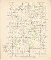
 1936 Inkster1936 Print · USGSWestern Wayne County was a landscape of institutions and early aviation in the years before the war. Researchers can trace the legacy of the Eloise Hospital and Infirmary, locate local landmarks like Wankin Mills, or find family roots near Perrinsville and St Marys Cem.
 - 1936 Map of Wyandotte
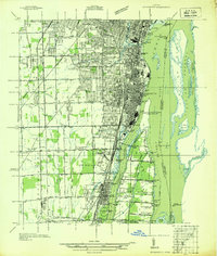 1936 Wyandotte1936 Print · USGSThe industrial corridor south of Detroit is captured here in the mid-1930s as manufacturing and residential grids expanded toward the river. Trace the development of local neighborhoods and landmarks like the Sibley Quarry, Sacred Heart Cem, and the Thorofare Canal on Grosse Ile.
 - 1936 Map of Dearborn
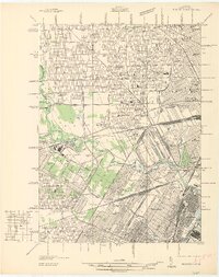 1936 Dearborn1936 Print · USGSMid-century Dearborn and West Detroit are captured in 1936, showing a landscape defined by the rise of the automotive industry. Genealogists and historians can locate early neighborhood schools like Mackenzie HS and landmark sites like Ford Airport and Greenfield Village.
 - 1936 Map of Wayne Co Airport
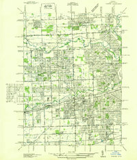
 1936 Wayne Co Airport1936 Print · USGSWayne County was evolving from a rural landscape of family farms to an aviation hub in the mid-1930s. Researchers can trace early schools and cemeteries like Hale Sch, Tryskett Sch, and West Mound Cem alongside the Wayne County Airport.
End of results
Showing maps 1-5 of 5
Top cities near Taylor
- Detroit historical maps
- Warren historical maps
- Canton Charter Township historical maps
- Canton Township historical maps
- Livonia historical maps
- Dearborn historical maps
See more
Top neighborhoods of Taylor
Frequently asked questions
- What are the different types of historical maps available for Taylor?
- What is the oldest map of Taylor?
- Where can I purchase historical maps of Taylor for my home or office?
- Where can I download high-res historical maps of Taylor?
- Are there historical topographic maps available for Taylor?
- Is there historical aerial imagery available for Taylor?
- Where are historical maps of Taylor sourced from?