1950s Maps of Taylor, Michigan
Explore 5 historic maps of Taylor from the 1950s. These maps offer a rare glimpse into what life looked like during the 1950s — showing old roads, neighborhoods, homes, and landmarks that have changed or disappeared over time.
Whether you're researching your family's past, planning a metal detecting trip, or studying how Taylor's landscape evolved across the 1950s, these high-resolution maps are a powerful tool for exploring the history of this region.
- Focus on a specific era: All maps on this page are from the 1950s, giving you a focused view of this time period.
- See what’s changed: Compare century-old streets, trails, and buildings to today's modern landscape using overlays and satellite layers.
- Research with precision: Use these maps for genealogy, historical research, land use analysis, or educational projects.
- View, download, or print: Maps are fully viewable online in high resolution, and can be downloaded or printed for your own records.
Start exploring Taylor's history through authentic maps from the 1950s. This is your window into the past.
Taylor, MI maps
(5)- 1952 Map of Detroit Wayne Airport, 1954 Print
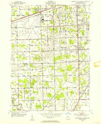 1952 Detroit Wayne Airport1954 Print · USGSMid-century Wayne County is captured here as the townships of Taylor and Romulus transition from rural landscapes to suburban hubs. Genealogists can trace family roots through Huron Cem, St Johns Sch, and the residential blocks of Rosenworth.2 unique versions available
 - 1952 Map of Inkster, 1954 Print
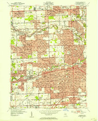 1952 Inkster1954 Print · USGSWestern Wayne County was rapidly transforming during the early fifties as the Detroit suburbs expanded toward the Rouge River forks. Genealogists and historians can locate numerous landmarks including Eloise Cem, the County Hospital, and the historic Nankin Mills.2 unique versions available
 - 1952 Map of Dearborn, 1954 Print
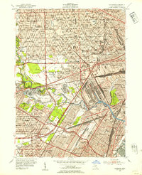 1952 Dearborn1954 Print · USGSMid-century Dearborn and western Detroit show a landscape defined by the automotive industry and rapid postwar expansion. Researchers can trace the massive rail yards, the Ford Rotunda, and neighborhood landmarks like Greenfield Village and Woodmere Cemetery.2 unique versions available
 - 1952 Map of Wyandotte, 1954 Print
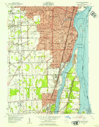 1952 Wyandotte1954 Print · USGSThe downriver industrial corridor south of Detroit thrives in the early fifties as suburbs like Allen Park and Lincoln Park expand. Genealogists and historians can trace neighborhood growth through dozens of local schools and landmarks like Elizabeth Park, Hange Airport, and Bloomdale Cem.2 unique versions available
 - 1954 Map of Detroit
 1954 Detroit1954 Print · USGSThe Detroit metro and its Ontario neighbors are shown at the height of the mid-century industrial era, just as the suburbs were rapidly expanding. Researchers can trace the massive rail networks of the Wabash Railroad or locate landmarks like Grosse Ile and Selfridge Air Force Base.
End of results
Showing maps 1-5 of 5
Top cities near Taylor
- Detroit historical maps
- Warren historical maps
- Canton Charter Township historical maps
- Canton Township historical maps
- Livonia historical maps
- Dearborn historical maps
See more
Top neighborhoods of Taylor
Frequently asked questions
- What are the different types of historical maps available for Taylor?
- What is the oldest map of Taylor?
- Where can I purchase historical maps of Taylor for my home or office?
- Where can I download high-res historical maps of Taylor?
- Are there historical topographic maps available for Taylor?
- Is there historical aerial imagery available for Taylor?
- Where are historical maps of Taylor sourced from?