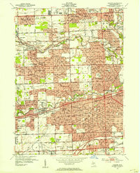
1952 Map of Inkster
USGS Topo · Published 1954About this map
The Middle Rouge River and Lower Rouge River anchor this post-war landscape of rapid suburbanization in Wayne County. While established settlements like Dearborn and Detroit show dense residential grids, newer developments like Rosedale Gardens and Grandale Gardens emerge alongside older rural landmarks. A notable concentration of institutional and religious sites includes the St Bernard Seminary, the St Joseph Retreat, and the extensive grounds of the County Hospital near Eloise.
Find a feature on this map
127 named features on this map. Tap any name to fly to it.
Don’t see what you’re looking for? This feature index may not catch every label — zoom into the map to look around manually.
Map Details
Editions of this 1952 Inkster Map
2 editions found
Other maps of this area

1905 · Wayne
USGS Topo · 1:62,500

1905 · Detroit
USGS Topo · 1:62,500

1906 · Wyandotte
USGS Topo · 1:62,500

1906 · Romulus
USGS Topo · 1:62,500

1912 · Wyandotte
USGS Topo · 1:62,500

1912 · Wayne
USGS Topo · 1:62,500

1918 · Detroit
USGS Topo · 1:62,500

1924 · Detroit
USGS Topo · 1:62,500

1928 · Romulus
USGS Topo · 1:62,500

1929 · Wyandotte
USGS Topo · 1:62,500