1920s Maps of Taylor, Michigan
Explore 3 historic maps of Taylor from the 1920s. These maps offer a rare glimpse into what life looked like during the 1920s — showing old roads, neighborhoods, homes, and landmarks that have changed or disappeared over time.
Whether you're researching your family's past, planning a metal detecting trip, or studying how Taylor's landscape evolved across the 1920s, these high-resolution maps are a powerful tool for exploring the history of this region.
- Focus on a specific era: All maps on this page are from the 1920s, giving you a focused view of this time period.
- See what’s changed: Compare century-old streets, trails, and buildings to today's modern landscape using overlays and satellite layers.
- Research with precision: Use these maps for genealogy, historical research, land use analysis, or educational projects.
- View, download, or print: Maps are fully viewable online in high resolution, and can be downloaded or printed for your own records.
Start exploring Taylor's history through authentic maps from the 1920s. This is your window into the past.
Taylor, MI maps
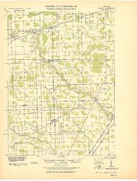
(3)- 1924 Map of Detroit
 1924 Detroit1924 Print · USGSDetroit and its industrial satellites thrive during the peak of the automotive era. Genealogists and historians can trace the early factory footprints of Dodge Bros. or locate old neighborhood landmarks like Navarre P. O. and Mt. Olivet Cemetery.
 - 1928 Map of Romulus
 1928 Romulus1928 Print · USGSSoutheast Michigan at the height of its rail-and-river era shows a dense network of transit lines and river towns. Genealogists can trace family roots through settlements like French Landing, Waltz, and South Rockwood or follow the path of the Pere Marquette RR.
 - 1929 Map of Wyandotte
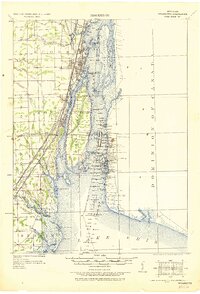 1929 Wyandotte1929 Print · USGSThe Detroit River shoreline comes alive in this late 1920s survey of the industrial corridor south of the city. Genealogists and historians can trace the early grids of Wyandotte and Amherstburg, or locate riverfront landmarks like Grosse Isle and Slocum Junc.
End of results
Showing maps 1-3 of 3
Top cities near Taylor
- Detroit historical maps
- Warren historical maps
- Canton Charter Township historical maps
- Canton Township historical maps
- Livonia historical maps
- Dearborn historical maps
See more
Top neighborhoods of Taylor
Frequently asked questions
- What are the different types of historical maps available for Taylor?
- What is the oldest map of Taylor?
- Where can I purchase historical maps of Taylor for my home or office?
- Where can I download high-res historical maps of Taylor?
- Are there historical topographic maps available for Taylor?
- Is there historical aerial imagery available for Taylor?
- Where are historical maps of Taylor sourced from?