1960s Maps of Big Stone County, Minnesota
Explore 4 historic maps of Big Stone County from the 1960s. These maps offer a rare glimpse into what life looked like during the 1960s — showing old roads, neighborhoods, homes, and landmarks that have changed or disappeared over time.
Whether you're researching your family's past, planning a metal detecting trip, or studying how Big Stone County's landscape evolved across the 1960s, these high-resolution maps are a powerful tool for exploring the history of this region.
- Focus on a specific era: All maps on this page are from the 1960s, giving you a focused view of this time period.
- See what’s changed: Compare century-old streets, trails, and buildings to today's modern landscape using overlays and satellite layers.
- Research with precision: Use these maps for genealogy, historical research, land use analysis, or educational projects.
- View, download, or print: Maps are fully viewable online in high resolution, and can be downloaded or printed for your own records.
Start exploring Big Stone County's history through authentic maps from the 1960s. This is your window into the past.
Big Stone County, MN maps
(4)- 1968 Map of Dry Wood Lake, 1970 Print
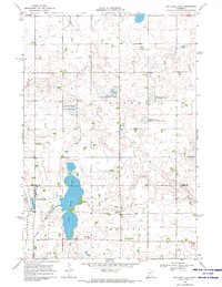 1968 Dry Wood Lake1970 Print · USGSThe Stevens and Swift County borderlands are preserved here in the late sixties, a landscape defined by glacial lakes and wildlife conservation. Genealogists and researchers can trace rural community hubs like Trinity Ch Cem, St Agnes Ch, and the shores of Dry Wood Lake.
 - 1968 Map of Lake Oliver, 1970 Print
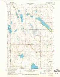 1968 Lake Oliver1970 Print · USGSSwift and Big Stone Counties are shown here in the late sixties, a landscape defined by glacial lakes and dedicated wildlife management. Genealogists and local historians can locate Immanuel Ch, Waldrum Cem, and the old Townhall among the prairie potholes.
 - 1968 Map of Artichoke Lake NW, 1970 Print
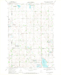 1968 Artichoke Lake NW1970 Print · USGSThe Stevens County prairie during the late 1960s is revealed here as a landscape of managed wetlands and quiet rural outposts. Local historians can locate School No 142, the Artichoke Lake Ch, and the central Townhall in Baker.
 - 1968 Map of Artichoke Lake, 1970 Print
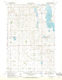 1968 Artichoke Lake1970 Print · USGSBig Stone County's glacial lake country is captured here in the late sixties as conservation efforts began reshaping the prairie. Researchers can locate the Akron Cem, the local Townhall, and early conservation boundaries like the Klages State Wildlife Management Areas.
End of results
Showing maps 1-4 of 4
Top cities of Big Stone County
- Ortonville historical maps
- Graceville historical maps
- Clinton historical maps
- Beardsley historical maps
- Foster historical maps
- Odessa historical maps
See more
Frequently asked questions
- What are the different types of historical maps available for Big Stone County?
- What is the oldest map of Big Stone County?
- Where can I purchase historical maps of Big Stone County for my home or office?
- Where can I download high-res historical maps of Big Stone County?
- Are there historical topographic maps available for Big Stone County?
- Is there historical aerial imagery available for Big Stone County?
- Where are historical maps of Big Stone County sourced from?