1910s Maps of Cass County, Minnesota
Explore 3 historic maps of Cass County from the 1910s. These maps offer a rare glimpse into what life looked like during the 1910s — showing old roads, neighborhoods, homes, and landmarks that have changed or disappeared over time.
Whether you're researching your family's past, planning a metal detecting trip, or studying how Cass County's landscape evolved across the 1910s, these high-resolution maps are a powerful tool for exploring the history of this region.
- Focus on a specific era: All maps on this page are from the 1910s, giving you a focused view of this time period.
- See what’s changed: Compare century-old streets, trails, and buildings to today's modern landscape using overlays and satellite layers.
- Research with precision: Use these maps for genealogy, historical research, land use analysis, or educational projects.
- View, download, or print: Maps are fully viewable online in high resolution, and can be downloaded or printed for your own records.
Start exploring Cass County's history through authentic maps from the 1910s. This is your window into the past.
Cass County, MN maps
(3)- 1916 Map of Pillager, 1957 Print
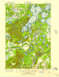 1916 Pillager1957 Print · USGSThe Brainerd Lakes region at the start of the twentieth century shows a landscape of growing settlements and interconnected waterways. Genealogists and historians can trace the foundations of local communities through several rural schoolhouses and the early paths of the Northern Pacific railroad through Pillager and Barrows.2 unique versions available
 - 1919 Map of Pillager
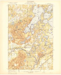 1919 Pillager1919 Print · USGSThe Gull Lake region in the years before the Great War shows a landscape transitioning between early frontier settlement and a burgeoning vacation destination. Genealogists can locate numerous rural schoolhouses like Home Brook School and Franzon School alongside the historic Grand View Lodge.3 unique versions available
 - 1919 Map of Leader, 1943 Print
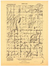 1919 Leader1943 Print · USGSCass County in the years following the Great War shows a landscape being transformed by drainage projects and early rural settlement. Genealogists and historians can trace the locations of numerous schools and vanished communities like Popler, Graff, and Leader.
End of results
Showing maps 1-3 of 3
Top cities of Cass County
- Sylvan historical maps
- Lake Shore historical maps
- East Gull Lake historical maps
- Walker historical maps
- Pine River historical maps
- Cass Lake historical maps
See more
Frequently asked questions
- What are the different types of historical maps available for Cass County?
- What is the oldest map of Cass County?
- Where can I purchase historical maps of Cass County for my home or office?
- Where can I download high-res historical maps of Cass County?
- Are there historical topographic maps available for Cass County?
- Is there historical aerial imagery available for Cass County?
- Where are historical maps of Cass County sourced from?