1960s Maps of Cass County, Minnesota
Explore 9 historic maps of Cass County from the 1960s. These maps offer a rare glimpse into what life looked like during the 1960s — showing old roads, neighborhoods, homes, and landmarks that have changed or disappeared over time.
Whether you're researching your family's past, planning a metal detecting trip, or studying how Cass County's landscape evolved across the 1960s, these high-resolution maps are a powerful tool for exploring the history of this region.
- Focus on a specific era: All maps on this page are from the 1960s, giving you a focused view of this time period.
- See what’s changed: Compare century-old streets, trails, and buildings to today's modern landscape using overlays and satellite layers.
- Research with precision: Use these maps for genealogy, historical research, land use analysis, or educational projects.
- View, download, or print: Maps are fully viewable online in high resolution, and can be downloaded or printed for your own records.
Start exploring Cass County's history through authentic maps from the 1960s. This is your window into the past.
Cass County, MN maps
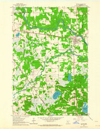
(9)- 1963 Map of Motley SE, 1964 Print
 1963 Motley SE1964 Print · USGSThe river and rail corridors of Morrison and Cass counties are frozen in time during the early 1960s. You can trace the Northern Pacific line across the Crow Wing River or locate local landmarks like the Motley Lookout Tower and Camp Shamineau.
 - 1963 Map of Motley, 1964 Print
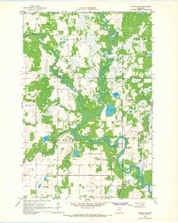
 1963 Motley1964 Print · USGSThe confluence of the Crow Wing and Long Prairie Rivers defines this pocket of central Minnesota in the early sixties. Genealogists and local historians can trace the footprint of Motley and Philbrook, along with sites like School No 1212 and St James Cem.2 unique versions available
 - 1964 Map of Hibbing
 1964 Hibbing1964 Print · USGSNorthern Minnesota’s iron-rich corridor is captured here during a peak era of mid-century industrial activity. Researchers can trace the rail-to-mine connections through Mesabi Range towns like Hibbing and Virginia or locate lakefront settlements near Pokegama Lake.
 - 1965 Map of Brainerd
 1965 Brainerd1965 Print · USGSNorth-central Minnesota in the mid-fifties presents a complex landscape of sprawling lake systems and established rail corridors. Genealogists and historians can trace the growth of timber towns along the Northern Pacific RR and explore early borders of the White Earth Indian Reservation or Tamarac National Wildlife Refuge.
 - 1966 Map of Staples NE, 1967 Print
 1966 Staples NE1967 Print · USGSWadena County at the height of the mid-sixties reveals a river-laced landscape where the Crow Wing River divides local townships. Genealogists can locate Montrose Cem and Covenant Ch, while aviation enthusiasts can trace the early layout of the Staples Municipal Airport.2 unique versions available
 - 1966 Map of Casino, 1967 Print
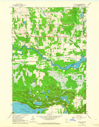
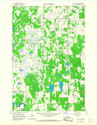
 1966 Casino1967 Print · USGSCass County's lake-dotted landscape is frozen in time during the mid-1960s, showing the quiet development of rural townships. Genealogists and local historians can trace the foundations of Casino and Bridgeman, or locate the Bridgeman Cem and nearby Townhall.2 unique versions available
 - 1966 Map of Motley NW, 1967 Print
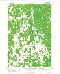
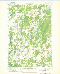
 1966 Motley NW1967 Print · USGSCentral Minnesota's lake country is captured here in the mid-1960s, showing a remote landscape of glacial wetlands and small settlements. Researchers can locate community landmarks like Esterly, Meadow Brook Sch, and the Swan Valley Cem among the many lakes.
 - 1969 Map of Burgen Lake, 1972 Print
 1969 Burgen Lake1972 Print · USGSThe Crow Wing River corridor in the late sixties reveals a landscape of protected timberlands and winding waterways. Researchers can trace the boundaries of Huntersville and Orton, locating sites like Huntersville Cem and the riverfront Frames Landing Campground.2 unique versions available
 - 1969 Map of Oylen, 1972 Print
 1969 Oylen1972 Print · USGSWadena County's riverfront and forest lands are captured in detail during the late sixties as the local conservation landscape took shape. Genealogists and historians can locate the Lyons Cem, the Indian Mounds, and the small community of Oylen along the Crow Wing River.
End of results
Showing maps 1-9 of 9
Top cities of Cass County
- Sylvan historical maps
- Lake Shore historical maps
- East Gull Lake historical maps
- Walker historical maps
- Pine River historical maps
- Cass Lake historical maps
See more
Frequently asked questions
- What are the different types of historical maps available for Cass County?
- What is the oldest map of Cass County?
- Where can I purchase historical maps of Cass County for my home or office?
- Where can I download high-res historical maps of Cass County?
- Are there historical topographic maps available for Cass County?
- Is there historical aerial imagery available for Cass County?
- Where are historical maps of Cass County sourced from?