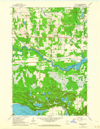
1963 Map of Motley SE
USGS Topo · Published 1964About this map
The confluence of the Long Prairie River and the Crow Wing River anchors this 1963 survey of the borderlands between Cass and Morrison counties. This landscape is defined by its glacial history, featuring a dense concentration of kettle lakes and wetlands including Shamineau Lake, North Twin Lake, and Stanchfield Lake. The Northern Pacific railroad tracks and Highway 210 cut through the northern townships of May and Motley, reflecting the region's transport and timber heritage.
Find a feature on this map
26 named features on this map. Tap any name to fly to it.
Don’t see what you’re looking for? This feature index may not catch every label — zoom into the map to look around manually.
Map Details
Editions of this 1963 Motley SE Map
This is the sole edition of this map. No revisions or reprints were ever made.
Other maps of this area

1916 · Pillager
USGS Topo · 1:62,500

1919 · Pillager
USGS Topo · 1:62,500

1948 · Belle Prairie
USGS Topo · 1:62,500

1948 · Cushing
USGS Topo · 1:62,500

1950 · Belle Prairie
USGS Topo · 1:62,500

1950 · Cushing
USGS Topo · 1:62,500

1953 · Brainerd
USGS Topo · 1:250,000

1954 · Pillager
USGS Topo · 1:24,000
1956 · Belle Prairie NW
USGS Topo · 1:24,000

1957 · Brainerd
USGS Topo · 1:250,000