1940s Maps of Clearwater County, Minnesota
Explore 2 historic maps of Clearwater County from the 1940s. These maps offer a rare glimpse into what life looked like during the 1940s — showing old roads, neighborhoods, homes, and landmarks that have changed or disappeared over time.
Whether you're researching your family's past, planning a metal detecting trip, or studying how Clearwater County's landscape evolved across the 1940s, these high-resolution maps are a powerful tool for exploring the history of this region.
- Focus on a specific era: All maps on this page are from the 1940s, giving you a focused view of this time period.
- See what’s changed: Compare century-old streets, trails, and buildings to today's modern landscape using overlays and satellite layers.
- Research with precision: Use these maps for genealogy, historical research, land use analysis, or educational projects.
- View, download, or print: Maps are fully viewable online in high resolution, and can be downloaded or printed for your own records.
Start exploring Clearwater County's history through authentic maps from the 1940s. This is your window into the past.
Clearwater County, MN maps
(2)- 1943 Map of Solway
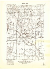 1943 Solway1943 Print · USGSBeltrami County's timber and rail landscape is meticulously detailed here in the years following the first World War. Genealogists and researchers can trace family roots through rural stops like Solway, Aure, and Neving, or locate landmarks such as Bagley Dam and Pony Lake.
 - 1943 Map of Bagley
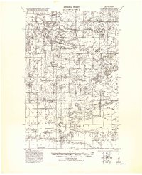 1943 Bagley1943 Print · USGSClearwater County at the height of the Second World War is shown here as a landscape of timbered tracts and scattered rail towns. Genealogists can trace family roots through numerous unnamed schools and churches near Bagley, Shevlin, and Clearbrook.
End of results
Showing maps 1-2 of 2
Top cities of Clearwater County
- Bagley historical maps
- Clearbrook historical maps
- Gonvick historical maps
- Minerva historical maps
- Shevlin historical maps
- Leonard historical maps
Frequently asked questions
- What are the different types of historical maps available for Clearwater County?
- What is the oldest map of Clearwater County?
- Where can I purchase historical maps of Clearwater County for my home or office?
- Where can I download high-res historical maps of Clearwater County?
- Are there historical topographic maps available for Clearwater County?
- Is there historical aerial imagery available for Clearwater County?
- Where are historical maps of Clearwater County sourced from?