1960s Maps of Clearwater County, Minnesota
Explore 15 historic maps of Clearwater County from the 1960s. These maps offer a rare glimpse into what life looked like during the 1960s — showing old roads, neighborhoods, homes, and landmarks that have changed or disappeared over time.
Whether you're researching your family's past, planning a metal detecting trip, or studying how Clearwater County's landscape evolved across the 1960s, these high-resolution maps are a powerful tool for exploring the history of this region.
- Focus on a specific era: All maps on this page are from the 1960s, giving you a focused view of this time period.
- See what’s changed: Compare century-old streets, trails, and buildings to today's modern landscape using overlays and satellite layers.
- Research with precision: Use these maps for genealogy, historical research, land use analysis, or educational projects.
- View, download, or print: Maps are fully viewable online in high resolution, and can be downloaded or printed for your own records.
Start exploring Clearwater County's history through authentic maps from the 1960s. This is your window into the past.
Clearwater County, MN maps
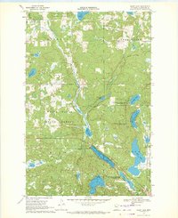
(15)- 1969 Map of Ebro, 1971 Print
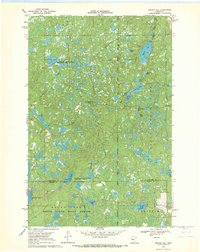
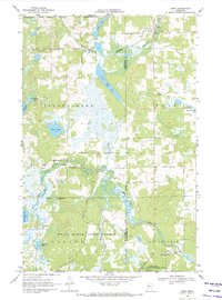 1969 Ebro1971 Print · USGSThe transition from the lake country to the timbered reaches of the White Earth State Forest is captured here in the late sixties. Genealogists and local historians can locate the Holiness Cem, trace the Burlington Northern line through Ebro, and find the riverside settlement of Pine Bend.
 - 1969 Map of Roy Lake, 1971 Print
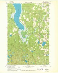
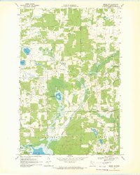
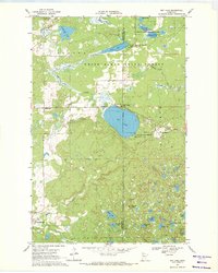 1969 Roy Lake1971 Print · USGSThe White Earth Indian Reservation in the late sixties reveals a landscape defined by deep woods and a dense network of glacial lakes. Local historians can trace the foundations of Naytahwaush and Mahkonce, or locate landmarks like the Cem. and Townhall.
 - 1969 Map of Clearbrook, 1971 Print
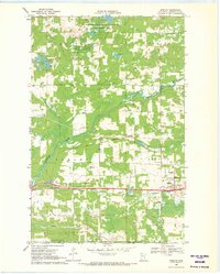
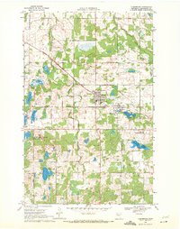 1969 Clearbrook1971 Print · USGSClearbrook and its surrounding townships in the late 1960s show a landscape of rail-connected industry and quiet country cemeteries. Genealogists and local historians can trace family ties at Elim Cem or Augustana Cem and locate old homesteads near the Soo Line tracks.
 - 1969 Map of Tulaby Lake, 1971 Print
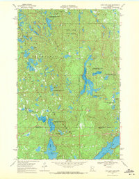
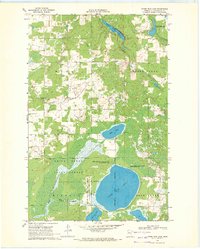
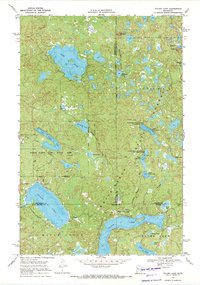 1969 Tulaby Lake1971 Print · USGSThe White Earth Indian Reservation in the late sixties is a dense mosaic of glacial lakes and state-managed timberlands. Researchers can locate the small community at Elbow Lake Village or trace routes past St Frances Cabrini Ch and Strawberry Mountain.2 unique versions available
 - 1969 Map of Anchor Hill, 1971 Print
 1969 Anchor Hill1971 Print · USGSNorthern Minnesota wilderness and conservation lands are captured here in the late sixties. Researchers can trace the White Earth Indian Reservation Boundary, an Old Railroad Grade, and the Anchor Hill Lookout Tower.2 unique versions available
 - 1969 Map of Leonard, 1971 Print
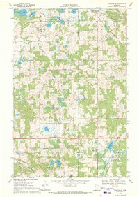
 1969 Leonard1971 Print · USGSClearwater County in the late sixties reveals a landscape of isolated farmsteads and rural parishes connected by the Soo Line. Genealogists can locate several historic burial grounds including Friendship Cem and Dudley Cem, alongside the small village of Leonard.
 - 1969 Map of Fosston SE, 1971 Print
 1969 Fosston SE1971 Print · USGSNorthwestern Minnesota in the late sixties reveals a landscape of winding rivers and rural townships at the edge of the Red Lake Indian Reservation Boundary. Genealogists can trace family roots at St Peter Cem and Freedom Cem, or follow the industrial path of the BURLINGTON NORTHERN railroad.
 - 1969 Map of Gonvick, 1971 Print
 1969 Gonvick1971 Print · USGSIn the late sixties, this portion of Clearwater County was a landscape of remote lake systems and small rail-side communities like Gonvick. Genealogists and historians can trace the Red Lake Indian Reservation Boundary and locate Bethlehem Ch or the Township Cem.
 - 1969 Map of Bagley, 1971 Print
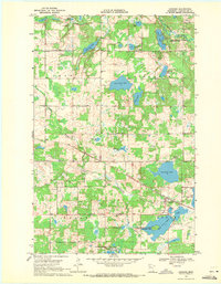
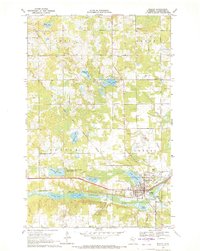 1969 Bagley1971 Print · USGSBagley and the Clearwater River valley are captured in the late sixties as the local rail and agricultural economy centered on the county seat. Researchers can trace the Old Red Lake Indian Reservation Boundary and locate family landmarks like Gran Cem, Concordia Ch Cem, and the County Fairground.
 - 1969 Map of Shevlin, 1971 Print
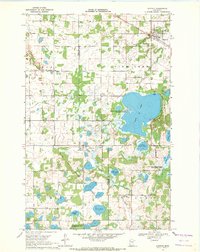
 1969 Shevlin1971 Print · USGSShevlin sits at a historic rail-and-river crossroads in Clearwater County during the late sixties. Genealogists can locate several family burial sites including Clearwater Cem and Landstad Cem, while the Burlington Northern line marks the town's industrial heart.
 - 1969 Map of Long Lost Lake, 1971 Print
 1969 Long Lost Lake1971 Print · USGSNorth-central Minnesota's wilderness is captured here in the late sixties, showcasing the dense lake country of the White Earth Indian Reservation. Trace the rugged terrain around Long Lost Lake, the shores of Juggler Lake, and the boundaries of White Earth State Forest.2 unique versions available
 - 1969 Map of Zerkel, 1972 Print
 1969 Zerkel1972 Print · USGSClearwater County's lake country is documented here in the late sixties, showing the interplay between the White Earth State Forest and the regional water network. Researchers can trace historic access points like Ponsford Landing, the isolated Sugarbush Lookout Tower, and the early footprints of Minerva and Zerkel.2 unique versions available
 - 1969 Map of Heart Lake, 1972 Print
 1969 Heart Lake1972 Print · USGSThe glacial lakes of Clearwater County are captured here in the late sixties, showing the overlap of forest and reservation lands. Genealogists and historians can locate Stevens Cem, School No 159, and traces of transport along an Old RR Grade.2 unique versions available
 - 1969 Map of Zerkel NW, 1972 Print
 1969 Zerkel NW1972 Print · USGSClearwater County's wetland interior is documented here in the late sixties, showing the intersection of reservation lands and state forests. Researchers can locate the Grace Chapel, the local Townhall, and various Gravel Pits near Tamarack Lake and the Wild Rice River.
 - 1969 Map of Upper Rice Lake, 1972 Print
 1969 Upper Rice Lake1972 Print · USGSClearwater County at the end of the sixties was a landscape of expansive wetlands and managed forests. Researchers can trace the boundaries of the White Earth Indian Reservation and locate local landmarks like Bethel Ch and Nora Cem.
End of results
Showing maps 1-15 of 15
Top cities of Clearwater County
- Bagley historical maps
- Clearbrook historical maps
- Gonvick historical maps
- Minerva historical maps
- Shevlin historical maps
- Leonard historical maps
Frequently asked questions
- What are the different types of historical maps available for Clearwater County?
- What is the oldest map of Clearwater County?
- Where can I purchase historical maps of Clearwater County for my home or office?
- Where can I download high-res historical maps of Clearwater County?
- Are there historical topographic maps available for Clearwater County?
- Is there historical aerial imagery available for Clearwater County?
- Where are historical maps of Clearwater County sourced from?