1970s Maps of Clearwater County, Minnesota
Explore 17 historic maps of Clearwater County from the 1970s. These maps offer a rare glimpse into what life looked like during the 1970s — showing old roads, neighborhoods, homes, and landmarks that have changed or disappeared over time.
Whether you're researching your family's past, planning a metal detecting trip, or studying how Clearwater County's landscape evolved across the 1970s, these high-resolution maps are a powerful tool for exploring the history of this region.
- Focus on a specific era: All maps on this page are from the 1970s, giving you a focused view of this time period.
- See what’s changed: Compare century-old streets, trails, and buildings to today's modern landscape using overlays and satellite layers.
- Research with precision: Use these maps for genealogy, historical research, land use analysis, or educational projects.
- View, download, or print: Maps are fully viewable online in high resolution, and can be downloaded or printed for your own records.
Start exploring Clearwater County's history through authentic maps from the 1970s. This is your window into the past.
Clearwater County, MN maps
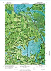
(17)- 1972 Map of Bagley Lake, 1974 Print
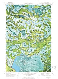
 1972 Bagley Lake1974 Print · USGSThe northern lake country of Beltrami County is documented here in the early 1970s, showcasing the intersection of tribal lands and state conservation areas. Researchers can locate community anchors like Faith Chapel, the Big Meadows Lookout Tower, and the lakeside settlement of Balm.
 - 1972 Map of Alida, 1974 Print
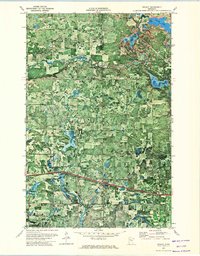
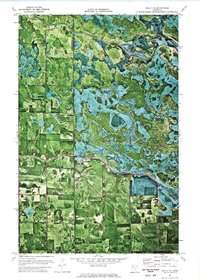
 1972 Alida1974 Print · USGSNorthern Minnesota's glacial lake country is frozen in time during the early seventies, capturing the headwaters region as it transitioned into the modern era. Genealogists and local historians can locate the Alida settlement, the Township Cem, and the winding course of the Little Mississippi River.
 - 1972 Map of Debs, 1974 Print
 1972 Debs1974 Print · USGSThe lake country of Beltrami County is revealed in the early 1970s through this detailed orthophotomap showing the woods and wetlands at a 1:24,000 scale. Researchers can locate the Sinclair Cem, the Soo Line tracks, and the small settlement of Debs.
 - 1972 Map of La Salle Lake, 1974 Print
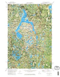
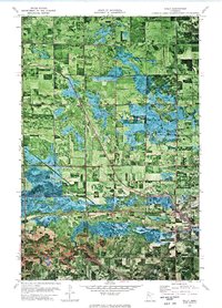
 1972 La Salle Lake1974 Print · USGSThe headwaters of the Mississippi were still a wild, forest-dominated landscape in the early seventies. Genealogists and historians can trace the rural layout of the region through landmarks like Old Solway Cem, Sol Lake Ch, and the settlement of Vem.
 - 1972 Map of Solway, 1974 Print
 1972 Solway1974 Print · USGSBeltrami and Clearwater counties appear in the early 1970s as timber and transit corridors define the rural landscape. Genealogists and local historians can trace family locations near Solway Cem or follow the Old Indian Treaty Boundary and the Old Railroad Grade.
 - 1972 Map of Lake Itasca, 1974 Print
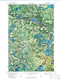
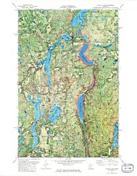
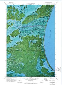
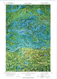
 1972 Lake Itasca1974 Print · USGSIn the early 1970s, the headwaters of the Mississippi River remained a focal point of conservation and research within the dense woods of Northern Minnesota. Researchers and genealogists can trace the layout of the Univ of Minn Forestry Sch, locate the Pioneer Cem, and find old landmarks like the Alton Heights Lookout Tower.2 unique versions available
 - 1972 Map of Berner NE, 1976 Print
 1972 Berner NE1976 Print · USGSThe western shores of Lower Red Lake come into focus in the early seventies, showing the managed hydrology of the Red Lake Indian Reservation. Trace local routes like Farm Station Road and the northern Winter Trail through the wetlands.
 - 1972 Map of Good Lake, 1976 Print
 1972 Good Lake1976 Print · USGSThe marshy borders of Beltrami, Pennington, and Clearwater counties are captured in the early 1970s, showcasing a landscape of seasonal routes and tribal boundaries. Researchers can trace the Red Lake Indian Reservation Boundary, the remote Little Oak Cem, and the path of the Winter Trail.
 - 1972 Map of Gully NE, 1976 Print
 1972 Gully NE1976 Print · USGSThe northern river country of Clearwater and Polk Counties is captured here in the early seventies, where the Red Lake River meets the reservation boundary. Researchers can trace land use near Hickory or locate the Gully State Wildlife Management Area and local Gravel Pit.
 - 1972 Map of Gully, 1976 Print
 1972 Gully1976 Print · USGSThe rural landscape around Gully is captured in the early seventies through detailed orthophotography and topographic surveys. Researchers can trace family history at Oak Grove Cem or study the hydrology of the Lost River and County Ditch No 49.
 - 1972 Map of Bailey Lake, 1976 Print
 1972 Bailey Lake1976 Print · USGSClearwater County and the Red Lake Indian Reservation are documented here in the early 1970s through high-altitude aerial photography. Researchers can trace the winding Red Lake River and locate specific features like the Rice Field and Gravel Pits.
 - 1972 Map of Berner, 1976 Print
 1972 Berner1976 Print · USGSClearwater County at the start of the 1970s is a landscape of complex wetlands and managed waterways along the Red Lake Indian Reservation. Researchers can trace the drainage patterns near Berner and locate local landmarks like United Lutheran Cem and Talge Lake.
 - 1972 Map of Gurneau Lake, 1976 Print
 1972 Gurneau Lake1976 Print · USGSClearwater County in the early 1970s shows a transition from the protected lands of the Red Lake Indian Reservation to rural homesteads. Local historians can trace family markers at the Clearwater Cem or locate the old Townhall and Schoolhouse Lake.
 - 1973 Map of Mosquito Creek, 1976 Print
 1973 Mosquito Creek1976 Print · USGSThe shores of the Red Lake Indian Reservation come into focus in the early 1970s, showing the intersection of lake and land. Researchers can trace the path of Mosquito Creek and locate a local Gravel Pit along Highway 89.
 - 1973 Map of Cahill Lake, 1976 Print
 1973 Cahill Lake1976 Print · USGSThe Red Lake Indian Reservation is captured in the early 1970s, showcasing a complex wetland landscape along the Beltrami and Clearwater county line. Genealogists and historians can trace the seasonal Winter Trail and locate family-named waters like Cahill Lake and Miskogineu Lake.
 - 1973 Map of Gimiwan Lake, 1976 Print
 1973 Gimiwan Lake1976 Print · USGSThe northern reaches of the Red Lake Indian Reservation are captured in the early 1970s, showing a landscape of dense wetlands and forest. Researchers can trace the path of the Winter Trail or locate the site of a solitary Lookout Tower.
 - 1977 Map of Grygla, 1978 Print
 1977 Grygla1978 Print · USGSNorthern Minnesota in the late seventies is a landscape of expansive state forests and managed wetlands. Genealogists and historians can trace the remote outposts of Malcolm, Four Town, and Erie or locate family landmarks near Randeen Ridge and Thief Lake.
End of results
Showing maps 1-17 of 17
Top cities of Clearwater County
- Bagley historical maps
- Clearbrook historical maps
- Gonvick historical maps
- Minerva historical maps
- Shevlin historical maps
- Leonard historical maps
Frequently asked questions
- What are the different types of historical maps available for Clearwater County?
- What is the oldest map of Clearwater County?
- Where can I purchase historical maps of Clearwater County for my home or office?
- Where can I download high-res historical maps of Clearwater County?
- Are there historical topographic maps available for Clearwater County?
- Is there historical aerial imagery available for Clearwater County?
- Where are historical maps of Clearwater County sourced from?