
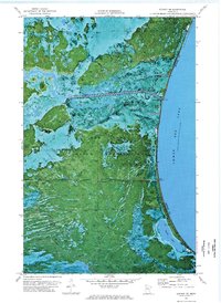
1973 Map of Mosquito Creek
USGS Topo · Published 1976About this map
The Red Lake Indian Reservation dominates this 1970s orthophotomap, showing a complex landscape of wetlands and forests along the northwestern shores of Lower Red Lake. This specialized survey combines traditional topographic contours with aerial photography, revealing the intricate drainage patterns of Mosquito Creek as it winds toward the lake. The terrain is marked by seasonal saturated soils and transition zones between open water and upland timber, providing a rare visual record of the shoreline before modern developments. Local industrial activity is represented by a Gravel Pit near the western edge, while the boundary between Clearwater and Beltrami counties bisects the southern marshlands. Highway 89 serves as the primary corridor through this largely wooded territory, connecting the lakeside environment to the broader region.
Find a feature on this map
7 named features on this map. Tap any name to fly to it.
Don’t see what you’re looking for? This feature index may not catch every label — zoom into the map to look around manually.
Map Details
Editions of this 1973 Mosquito Creek Map
This is the sole edition of this map. No revisions or reprints were ever made.
Other maps of this area

1918 · Jelle
USGS Topo · 1:62,500

1919 · Churnes
USGS Topo · 1:62,500

1954 · Bemidji
USGS Topo · 1:250,000

1954 · Roseau
USGS Topo · 1:250,000

1957 · Roseau
USGS Topo · 1:250,000

1957 · Bemidji
USGS Topo · 1:250,000

1958 · Bemidji
USGS Topo · 1:250,000

1958 · Roseau
USGS Topo · 1:250,000
1972 · Berner NE
USGS Topo · 1:24,000

1973 · Manomin Creek SE
USGS Topo · 1:24,000