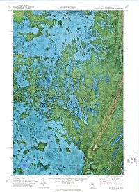
1973 Map of Gimiwan Lake
USGS Topo · Published 1976About this map
Red Lake Indian Reservation lands dominate this northern Minnesota landscape, captured during a 1973 field check that combined aerial photography with traditional topographic surveying. The terrain is defined by a complex mosaic of wetlands and forest, where the only significant human transit route is the seasonal Winter Trail cutting through the center of the sheet. To the south, the waters of Gimiwan Lake sit just across the boundary line shared by Beltrami and Clearwater Counties. This orthophotomap provides a rare hybrid view of the natural forest cover alongside surveyed elevation data, highlighting local landmarks such as a isolated Lookout Tower and a singular Ridge rising above the surrounding marshlands. A small Gravel Pit near the eastern edge suggests localized resource extraction in an otherwise largely undeveloped wilderness environment.
Find a feature on this map
7 named features on this map. Tap any name to fly to it.
Don’t see what you’re looking for? This feature index may not catch every label — zoom into the map to look around manually.
Map Details
Editions of this 1973 Gimiwan Lake Map
This is the sole edition of this map. No revisions or reprints were ever made.
Other maps of this area

1918 · Jelle
USGS Topo · 1:62,500

1919 · Churnes
USGS Topo · 1:62,500

1954 · Bemidji
USGS Topo · 1:250,000

1954 · Roseau
USGS Topo · 1:250,000

1957 · Roseau
USGS Topo · 1:250,000

1957 · Bemidji
USGS Topo · 1:250,000

1958 · Bemidji
USGS Topo · 1:250,000

1958 · Roseau
USGS Topo · 1:250,000
1972 · Berner NE
USGS Topo · 1:24,000
1972 · Bailey Lake
USGS Topo · 1:24,000