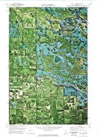
1972 Map of Gully NE
USGS Topo · Published 1976About this map
The Red Lake River and the Clearwater River converge in this northern Minnesota landscape, creating a complex network of wetlands and shifting watercourses. Much of the northeastern portion of this orthophotomap is dominated by the Red Lake Indian Reservation, where the intricate hydrology of the Red Lake drainage system is clearly visible. To the southwest, the Gully State Wildlife Management Area provides protected terrain adjacent to the managed agricultural lands of Hickory, Johnson, and Hanson. The map reveals the precise intersection of three county lines—Pennington, Polk, and Clearwater—which underscores the area's importance as a jurisdictional boundary. Local industry is represented by a small Gravel Pit, while the orthophoto detail provides an unfiltered view of field patterns and riparian corridors during the early 1970s.
Find a feature on this map
11 named features on this map. Tap any name to fly to it.
Don’t see what you’re looking for? This feature index may not catch every label — zoom into the map to look around manually.
Map Details
Editions of this 1972 Gully NE Map
This is the sole edition of this map. No revisions or reprints were ever made.
Other maps of this area

1918 · Jelle
USGS Topo · 1:62,500

1919 · Churnes
USGS Topo · 1:62,500

1919 · Winsor
USGS Topo · 1:62,500

1954 · Bemidji
USGS Topo · 1:250,000

1954 · Roseau
USGS Topo · 1:250,000

1957 · Roseau
USGS Topo · 1:250,000

1957 · Bemidji
USGS Topo · 1:250,000

1958 · Bemidji
USGS Topo · 1:250,000

1958 · Roseau
USGS Topo · 1:250,000

1972 · Erie
USGS Topo · 1:24,000