1940s Maps of Crow Wing County, Minnesota
Explore 2 historic maps of Crow Wing County from the 1940s. These maps offer a rare glimpse into what life looked like during the 1940s — showing old roads, neighborhoods, homes, and landmarks that have changed or disappeared over time.
Whether you're researching your family's past, planning a metal detecting trip, or studying how Crow Wing County's landscape evolved across the 1940s, these high-resolution maps are a powerful tool for exploring the history of this region.
- Focus on a specific era: All maps on this page are from the 1940s, giving you a focused view of this time period.
- See what’s changed: Compare century-old streets, trails, and buildings to today's modern landscape using overlays and satellite layers.
- Research with precision: Use these maps for genealogy, historical research, land use analysis, or educational projects.
- View, download, or print: Maps are fully viewable online in high resolution, and can be downloaded or printed for your own records.
Start exploring Crow Wing County's history through authentic maps from the 1940s. This is your window into the past.
Crow Wing County, MN maps
(2)- 1948 Map of Belle Prairie, 1961 Print
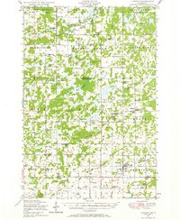
 1948 Belle Prairie1961 Print · USGSMorrison and Crow Wing counties are captured here in the late 1940s, a landscape defined by military grounds and a dense network of country schools. Researchers can trace the legacy of early settlements through Old Darling Mission Cemetery, the Northern Pacific line at Darling Switch, and St Mathias Church.
 - 1948 Map of Lastrup, 1971 Print
 1948 Lastrup1971 Print · USGSCentral Minnesota farming communities thrive along the riverbanks in this post-war landscape. Genealogists can trace family roots through numerous rural landmarks like Holy Cross Church, the Freedhem Cemetery, and the Granite Town Hall.
End of results
Showing maps 1-2 of 2
Top cities of Crow Wing County
- Brainerd historical maps
- Baxter historical maps
- Crosby historical maps
- Nisswa historical maps
- Pequot Lakes historical maps
- Breezy Point historical maps
See more
Frequently asked questions
- What are the different types of historical maps available for Crow Wing County?
- What is the oldest map of Crow Wing County?
- Where can I purchase historical maps of Crow Wing County for my home or office?
- Where can I download high-res historical maps of Crow Wing County?
- Are there historical topographic maps available for Crow Wing County?
- Is there historical aerial imagery available for Crow Wing County?
- Where are historical maps of Crow Wing County sourced from?