1960s Maps of Crow Wing County, Minnesota
Explore 4 historic maps of Crow Wing County from the 1960s. These maps offer a rare glimpse into what life looked like during the 1960s — showing old roads, neighborhoods, homes, and landmarks that have changed or disappeared over time.
Whether you're researching your family's past, planning a metal detecting trip, or studying how Crow Wing County's landscape evolved across the 1960s, these high-resolution maps are a powerful tool for exploring the history of this region.
- Focus on a specific era: All maps on this page are from the 1960s, giving you a focused view of this time period.
- See what’s changed: Compare century-old streets, trails, and buildings to today's modern landscape using overlays and satellite layers.
- Research with precision: Use these maps for genealogy, historical research, land use analysis, or educational projects.
- View, download, or print: Maps are fully viewable online in high resolution, and can be downloaded or printed for your own records.
Start exploring Crow Wing County's history through authentic maps from the 1960s. This is your window into the past.
Crow Wing County, MN maps
(4)- 1960 Map of Cross Lake, 1961 Print
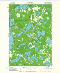 1960 Cross Lake1961 Print · USGSCrow Wing County's lake country in the early sixties was a burgeoning landscape of woodland recreation and small-town growth. You can locate family history at Pinewood Cemetery, trace the old roads around Manhattan Beach, or find mid-century landmarks like the Drive-in Theater.4 unique versions available
 - 1965 Map of Brainerd
 1965 Brainerd1965 Print · USGSNorth-central Minnesota in the mid-fifties presents a complex landscape of sprawling lake systems and established rail corridors. Genealogists and historians can trace the growth of timber towns along the Northern Pacific RR and explore early borders of the White Earth Indian Reservation or Tamarac National Wildlife Refuge.
 - 1968 Map of Platte Lake, 1970 Print
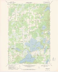 1968 Platte Lake1970 Print · USGSThe lake country of Crow Wing and Morrison Counties is captured here in the late sixties as recreation and local industry shaped the land. Researchers can trace rural landmarks like Pine Center, Emmanuel Ch, and the waters of Platte Lake.2 unique versions available
 - 1968 Map of Vineland, 1970 Print
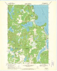 1968 Vineland1970 Print · USGSThe southwestern shores of Mille Lacs Lake are captured here in the late sixties, centered on the settlement of Vineland. Researchers can trace local history through the Alliance Mission, Lakewood Cem, and the boundaries of Mille Lacs Kathio State Park.
End of results
Showing maps 1-4 of 4
Top cities of Crow Wing County
- Brainerd historical maps
- Baxter historical maps
- Crosby historical maps
- Nisswa historical maps
- Pequot Lakes historical maps
- Breezy Point historical maps
See more
Frequently asked questions
- What are the different types of historical maps available for Crow Wing County?
- What is the oldest map of Crow Wing County?
- Where can I purchase historical maps of Crow Wing County for my home or office?
- Where can I download high-res historical maps of Crow Wing County?
- Are there historical topographic maps available for Crow Wing County?
- Is there historical aerial imagery available for Crow Wing County?
- Where are historical maps of Crow Wing County sourced from?