1970s Maps of Trommald, Minnesota
Explore 4 historic maps of Trommald from the 1970s. These maps offer a rare glimpse into what life looked like during the 1970s — showing old roads, neighborhoods, homes, and landmarks that have changed or disappeared over time.
Whether you're researching your family's past, planning a metal detecting trip, or studying how Trommald's landscape evolved across the 1970s, these high-resolution maps are a powerful tool for exploring the history of this region.
- Focus on a specific era: All maps on this page are from the 1970s, giving you a focused view of this time period.
- See what’s changed: Compare century-old streets, trails, and buildings to today's modern landscape using overlays and satellite layers.
- Research with precision: Use these maps for genealogy, historical research, land use analysis, or educational projects.
- View, download, or print: Maps are fully viewable online in high resolution, and can be downloaded or printed for your own records.
Start exploring Trommald's history through authentic maps from the 1970s. This is your window into the past.
Trommald, MN maps
(4)- 1973 Map of Cuyuna, 1975 Print
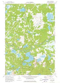 1973 Cuyuna1975 Print · USGSThe Cuyuna Iron Range comes alive in the early 1970s, showing a landscape where heavy industry and Minnesota's lake country meet. Genealogists and historians can locate the Yawkey Mine, trace the Burlington Northern tracks, and find old settlements like Cuyuna and Wolford.
 - 1973 Map of Crosby, 1976 Print
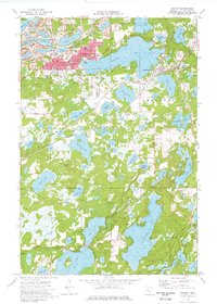 1973 Crosby1976 Print · USGSThe Cuyuna Iron Range comes into sharp focus during the 1970s, showing a landscape defined by industrial iron pits and expansive lakes. Genealogists and historians can trace the mining footprint at the Portsmouth Mine or locate family sites near Irondale Cem and Deerwood Cem.
 - 1973 Map of Riverton, 1976 Print
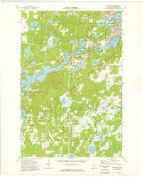 1973 Riverton1976 Print · USGSCrow Wing County's iron-mining heritage is on full display in the early seventies, centered on the village of Riverton. Researchers can trace the extensive footprints of the Sagamore Mine and Snowshoe Mine or locate early settlements at Loerch and Woodrow.
 - 1976 Map of Pine River, 1994 Print
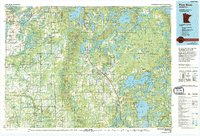 1976 Pine River1994 Print · USGSNorthern Minnesota's lake country is captured here during the mid-seventies, showing the expansion of recreation around Pequot Lakes and Nisswa. Researchers can trace the Burlington Northern rail line and locate forest landmarks within the Paul Bunyan State Forest and Chippewa National Forest.
End of results
Showing maps 1-4 of 4
Top cities near Trommald
- Brainerd historical maps
- Baxter historical maps
- Crosby historical maps
- Breezy Point historical maps
- Emily historical maps
- Bay Lake historical maps
See more
Frequently asked questions
- What are the different types of historical maps available for Trommald?
- What is the oldest map of Trommald?
- Where can I purchase historical maps of Trommald for my home or office?
- Where can I download high-res historical maps of Trommald?
- Are there historical topographic maps available for Trommald?
- Is there historical aerial imagery available for Trommald?
- Where are historical maps of Trommald sourced from?