1970s Maps of Greenvale Township, Minnesota
Explore 2 historic maps of Greenvale Township from the 1970s. These maps offer a rare glimpse into what life looked like during the 1970s — showing old roads, neighborhoods, homes, and landmarks that have changed or disappeared over time.
Whether you're researching your family's past, planning a metal detecting trip, or studying how Greenvale Township's landscape evolved across the 1970s, these high-resolution maps are a powerful tool for exploring the history of this region.
- Focus on a specific era: All maps on this page are from the 1970s, giving you a focused view of this time period.
- See what’s changed: Compare century-old streets, trails, and buildings to today's modern landscape using overlays and satellite layers.
- Research with precision: Use these maps for genealogy, historical research, land use analysis, or educational projects.
- View, download, or print: Maps are fully viewable online in high resolution, and can be downloaded or printed for your own records.
Start exploring Greenvale Township's history through authentic maps from the 1970s. This is your window into the past.
Greenvale Township, MN maps
(2)- 1974 Map of New Market, 1976 Print
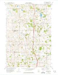 1974 New Market1976 Print · USGSThe rural borderlands of Scott and Rice counties are captured here in the mid-seventies, showing a landscape of small farming towns and expanding regional transit. Genealogists and local historians can trace the roads to Solor Ch, West Christiania Cem, and the settlement of Hazelwood.
 - 1974 Map of Castle Rock, 1976 Print
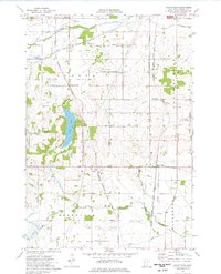 1974 Castle Rock1976 Print · USGSDakota County's rural landscape is captured here in the mid-seventies, showing a blend of traditional farming and new aviation infrastructure. Trace family history at East Christiania or locate rural landmarks like St John Cem and the Airlake Industrial Airport.
End of results
Showing maps 1-2 of 2
Top cities near Greenvale Township
- Burnsville historical maps
- Lakeville historical maps
- Apple Valley historical maps
- Shakopee historical maps
- Savage historical maps
- Prior Lake historical maps
See more
Frequently asked questions
- What are the different types of historical maps available for Greenvale Township?
- What is the oldest map of Greenvale Township?
- Where can I purchase historical maps of Greenvale Township for my home or office?
- Where can I download high-res historical maps of Greenvale Township?
- Are there historical topographic maps available for Greenvale Township?
- Is there historical aerial imagery available for Greenvale Township?
- Where are historical maps of Greenvale Township sourced from?