1960s Maps of Mendota Heights, Minnesota
Explore 4 historic maps of Mendota Heights from the 1960s. These maps offer a rare glimpse into what life looked like during the 1960s — showing old roads, neighborhoods, homes, and landmarks that have changed or disappeared over time.
Whether you're researching your family's past, planning a metal detecting trip, or studying how Mendota Heights's landscape evolved across the 1960s, these high-resolution maps are a powerful tool for exploring the history of this region.
- Focus on a specific era: All maps on this page are from the 1960s, giving you a focused view of this time period.
- See what’s changed: Compare century-old streets, trails, and buildings to today's modern landscape using overlays and satellite layers.
- Research with precision: Use these maps for genealogy, historical research, land use analysis, or educational projects.
- View, download, or print: Maps are fully viewable online in high resolution, and can be downloaded or printed for your own records.
Start exploring Mendota Heights's history through authentic maps from the 1960s. This is your window into the past.
Mendota Heights, MN maps
(4)- 1967 Map of Inver Grove Heights, 1969 Print
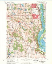 1967 Inver Grove Heights1969 Print · USGSThe Mississippi River corridor south of the Twin Cities thrives in the late sixties as rail and river industry meet. Trace family roots at Union Cem and St Patricks Ch, or explore the mid-century footprint of South St Paul and Wescott.4 unique versions available
 - 1967 Map of St. Paul SW, 1969 Print
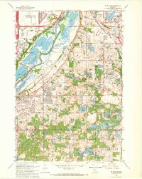 1967 St. Paul SW1969 Print · USGSDakota and Hennepin counties are captured in a moment of suburban transformation during the late sixties. Trace the early development of Bloomington and Burnsville alongside landmarks like Metropolitan Stadium and Fort Snelling National Cemetery.6 unique versions available
 - 1967 Map of St. Paul West, 1969 Print
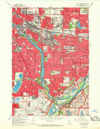 1967 St. Paul West1969 Print · USGSThe Twin Cities emerge in full mid-century detail during a period of significant urban density and infrastructure expansion. Researchers can trace the grounds of the State Fairgrounds, the historic Minnehaha Falls, and the complex layout of Fort Snelling.5 unique versions available
 - 1967 Map of St. Paul East, 1969 Print
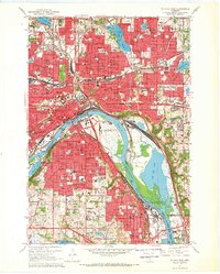 1967 St. Paul East1969 Print · USGSThe Twin Cities region shows its mid-century industrial and civic expansion in this survey of the riverfront and downtown core. Researchers can trace the development of neighborhood institutions like Oakland Cemetery, the Stockyards in South St. Paul, and the St Paul Cathedral.5 unique versions available
End of results
Showing maps 1-4 of 4
Top cities near Mendota Heights
- Minneapolis historical maps
- Saint Paul historical maps
- Bloomington historical maps
- Brooklyn Park historical maps
- Woodbury historical maps
- Eagan historical maps
See more
Frequently asked questions
- What are the different types of historical maps available for Mendota Heights?
- What is the oldest map of Mendota Heights?
- Where can I purchase historical maps of Mendota Heights for my home or office?
- Where can I download high-res historical maps of Mendota Heights?
- Are there historical topographic maps available for Mendota Heights?
- Is there historical aerial imagery available for Mendota Heights?
- Where are historical maps of Mendota Heights sourced from?