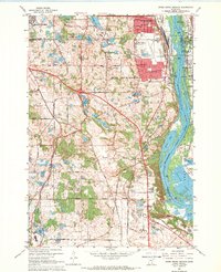
1967 Map of Inver Grove Heights
USGS Topo · Published 1969About this map
Mississippi River transport and industry dominate this riverbend landscape in the late 1960s, where the Chicago Rock Island and Pacific and other major rail lines converge near the South St Paul Municipal Airport. The survey captures the suburban expansion of Inver Grove Heights and Mendota Heights as new residential grids and schools like Simley High Sch begin to press against established rural features. Local heritage is preserved in numerous early landmarks, including St Patrick Cem and the Salem Kirche Cem. To the east, the river's complexity is evident through the many backwaters and channels surrounding Grey Cloud Island and Baldwin Lake, providing a clear view of the transition from industrial riverfronts at Roseport and Pine Bend to the natural riparian environment before modern development further altered the shoreline.
Find a feature on this map
67 named features on this map. Tap any name to fly to it.
Don’t see what you’re looking for? This feature index may not catch every label — zoom into the map to look around manually.
Map Details
Editions of this 1967 Inver Grove Heights Map
4 editions found
Other maps of this area

1896 · St. Paul
USGS Topo · 1:62,500

1946 · Hudson
USGS Topo · 1:62,500

1949 · Hudson
USGS Topo · 1:62,500

1949 · Lake Elmo
USGS Topo · 1:24,000

1950 · Lake Elmo
USGS Topo · 1:24,000

1950 · St Paul Park
USGS Topo · 1:24,000

1951 · St Paul Park
USGS Topo · 1:24,000

1951 · St. Paul West
USGS Topo · 1:24,000

1951 · Inver Grove
USGS Topo · 1:24,000

1951 · St. Paul SW
USGS Topo · 1:24,000