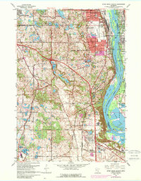
1967 Map of Inver Grove Heights
USGS Topo · Published 1989About this map
The Mississippi River corridor dominates this late-1960s landscape, illustrating the industrial and residential growth south of the Twin Cities. Urban expansion is evident through a network of newly developed streets like 70th Street and Yankee Doodle Road, while the traditional river economy persists at Roseport and Pine Bend. The map documents a community in transition, where established rural sites like Salem Church Cem and the St Patricks Ch sit alongside modern landmarks such as the South St Paul Municipal Airport (Fleming Field).
Find a feature on this map
62 named features on this map. Tap any name to fly to it.
Don’t see what you’re looking for? This feature index may not catch every label — zoom into the map to look around manually.
Map Details
Editions of this 1967 Inver Grove Heights Map
4 editions found
Other maps of this area

1896 · St. Paul
USGS Topo · 1:62,500

1946 · Hudson
USGS Topo · 1:62,500

1949 · Hudson
USGS Topo · 1:62,500

1949 · Lake Elmo
USGS Topo · 1:24,000

1950 · Lake Elmo
USGS Topo · 1:24,000

1950 · St Paul Park
USGS Topo · 1:24,000

1951 · St Paul Park
USGS Topo · 1:24,000

1951 · St. Paul West
USGS Topo · 1:24,000

1951 · Inver Grove
USGS Topo · 1:24,000

1951 · St. Paul SW
USGS Topo · 1:24,000