1970s Maps of Faribault County, Minnesota
Explore 4 historic maps of Faribault County from the 1970s. These maps offer a rare glimpse into what life looked like during the 1970s — showing old roads, neighborhoods, homes, and landmarks that have changed or disappeared over time.
Whether you're researching your family's past, planning a metal detecting trip, or studying how Faribault County's landscape evolved across the 1970s, these high-resolution maps are a powerful tool for exploring the history of this region.
- Focus on a specific era: All maps on this page are from the 1970s, giving you a focused view of this time period.
- See what’s changed: Compare century-old streets, trails, and buildings to today's modern landscape using overlays and satellite layers.
- Research with precision: Use these maps for genealogy, historical research, land use analysis, or educational projects.
- View, download, or print: Maps are fully viewable online in high resolution, and can be downloaded or printed for your own records.
Start exploring Faribault County's history through authentic maps from the 1970s. This is your window into the past.
Faribault County, MN maps
(4)- 1972 Map of Buffalo Center, 1975 Print
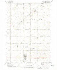 1972 Buffalo Center1975 Print · USGSWinnebago County agriculture and small-town life are centered around Buffalo Center and Rake during the early seventies. Genealogists can locate several local burial grounds, including Olena Mound Cem and Township Cem, while following the path of the Chicago Rock Island and Pacific railroad.
 - 1972 Map of Buffalo Center NE, 1975 Print
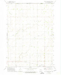 1972 Buffalo Center NE1975 Print · USGSWinnebago County farm country is captured here in the early 1970s as the rail and road networks of northern Iowa reached their modern form. Researchers can trace the CHICAGO ROCK ISLAND AND PACIFIC tracks through Thompson or locate local landmarks like Trinity Ch and Florence Park.
 - 1972 Map of Vinje, 1975 Print
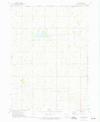 1972 Vinje1975 Print · USGSWinnebago County farmsteads and glacial lakes define this borderland region in the early seventies. Genealogists can locate rural landmarks like Bethel Ch, North Prairie Ch, and the small settlement of Vinje along the Chicago and North Western tracks.
 - 1972 Map of Lakota, 1975 Print
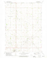 1972 Lakota1975 Print · USGSThe northern Kossuth County borderlands come to life in the early seventies, showing a landscape of precise township lines and agricultural engineering. Genealogists and local historians can trace family-named sites like Boehm and Stevens or the grounds of St Matthews Cem.
End of results
Showing maps 1-4 of 4
Top cities of Faribault County
- Blue Earth historical maps
- Wells historical maps
- Winnebago historical maps
- Elmore historical maps
- Minnesota Lake historical maps
- Kiester historical maps
See more
Frequently asked questions
- What are the different types of historical maps available for Faribault County?
- What is the oldest map of Faribault County?
- Where can I purchase historical maps of Faribault County for my home or office?
- Where can I download high-res historical maps of Faribault County?
- Are there historical topographic maps available for Faribault County?
- Is there historical aerial imagery available for Faribault County?
- Where are historical maps of Faribault County sourced from?