1980s Maps of Faribault County, Minnesota
Explore 10 historic maps of Faribault County from the 1980s. These maps offer a rare glimpse into what life looked like during the 1980s — showing old roads, neighborhoods, homes, and landmarks that have changed or disappeared over time.
Whether you're researching your family's past, planning a metal detecting trip, or studying how Faribault County's landscape evolved across the 1980s, these high-resolution maps are a powerful tool for exploring the history of this region.
- Focus on a specific era: All maps on this page are from the 1980s, giving you a focused view of this time period.
- See what’s changed: Compare century-old streets, trails, and buildings to today's modern landscape using overlays and satellite layers.
- Research with precision: Use these maps for genealogy, historical research, land use analysis, or educational projects.
- View, download, or print: Maps are fully viewable online in high resolution, and can be downloaded or printed for your own records.
Start exploring Faribault County's history through authentic maps from the 1980s. This is your window into the past.
Faribault County, MN maps
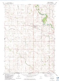
(10)- 1982 Map of Bricelyn, 1983 Print
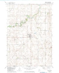 1982 Bricelyn1983 Print · USGSBricelyn and the surrounding Faribault County townships are captured here in the early eighties as a high-functioning agricultural landscape. Genealogists and local historians can trace the Chicago and North Western rail line and locate Bricelyn Cem and Clayton Cem.
 - 1982 Map of Kiester, 1983 Print
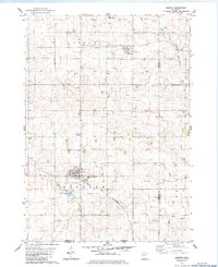 1982 Kiester1983 Print · USGSSouthern Faribault County is shown here in the early eighties as a productive agricultural region tied together by the Chicago and North Western rail line. Researchers can locate family landmarks like St Johns Cem, the community of Walters, and several local Gravel Pits.
 - 1982 Map of Oza Tanka Lakebed, 1983 Print
 1982 Oza Tanka Lakebed1983 Print · USGSFaribault County agriculture and drainage systems are captured here in the early 1980s. Local researchers can locate rural family landmarks like St Marys Cem and King Cem, or trace the complex network of Oza Tanka Lakebed and Brush Creek.
 - 1982 Map of Wells, 1983 Print
 1982 Wells1983 Print · USGSWells and the surrounding Faribault County prairie are captured here in the early eighties as a thriving agricultural and rail corridor. Genealogists and local historians can trace the foundations of the community through St Casimir Cem, Rice Lake Cem, and the rail stops at Thistius and Baroda.
 - 1982 Map of Frost, 1983 Print
 1982 Frost1983 Print · USGSSouthern Minnesota farmland near the Iowa border is captured here in the early eighties, centered on the village of Frost. Genealogists and local historians can trace family plots across Emerald township and locate landmarks like Bethany Ch and Emerald Cem.
 - 1982 Map of Brush Creek, 1983 Print
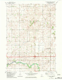
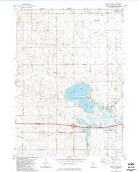 1982 Brush Creek1983 Print · USGSFaribault County in the early eighties was a landscape of managed wetlands and rural crossroads. Local historians can trace the foundations of the community at the Townhall, Brush Creek Ch, and family sites near Walnut Lake Cem.
 - 1985 Map of Mason City
 1985 Mason City1985 Print · USGSThe Northern Iowa and Southern Minnesota borderlands are captured here in the mid-eighties, showing a region defined by agricultural drainage and rail heritage. Genealogists and historians can trace the grid of rural townships and find local landmarks like Pilot Knob State Park, Nora Springs, and Clear Lake State Park.2 unique versions available
 - 1985 Map of Estherville
 1985 Estherville1985 Print · USGSNorthern Iowa in the mid-eighties was a landscape of grid-patterned agriculture and vast marshland conservation. Genealogists can locate rural landmarks like Oak Hill Cemetery and Fourmile Lake School, or trace the rail lines of the Chicago and North Western.2 unique versions available
 - 1985 Map of Albert Lea
 1985 Albert Lea1985 Print · USGSSouthern Minnesota's agricultural heartland is documented here in the mid-1980s, showing a landscape defined by industrial rail lines and managed waterways. Trace the historic routes of the Chicago and North Western and explore settlements like Hollandale, New Richland, and Bricelyn.2 unique versions available
 - 1985 Map of Fairmont, 1991 Print
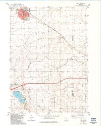
 1985 Fairmont1991 Print · USGSSouthern Minnesota in the mid-eighties shows a robust network of prairie towns and rail-connected agricultural hubs. Genealogists can trace family footprints across Rolling Green and Manyaska or locate old homesteads near Fox Lake and the Chicago & North Western line.
End of results
Showing maps 1-10 of 10
Top cities of Faribault County
- Blue Earth historical maps
- Wells historical maps
- Winnebago historical maps
- Elmore historical maps
- Minnesota Lake historical maps
- Kiester historical maps
See more
Frequently asked questions
- What are the different types of historical maps available for Faribault County?
- What is the oldest map of Faribault County?
- Where can I purchase historical maps of Faribault County for my home or office?
- Where can I download high-res historical maps of Faribault County?
- Are there historical topographic maps available for Faribault County?
- Is there historical aerial imagery available for Faribault County?
- Where are historical maps of Faribault County sourced from?