1950s Maps of Faribault County, Minnesota
Explore 7 historic maps of Faribault County from the 1950s. These maps offer a rare glimpse into what life looked like during the 1950s — showing old roads, neighborhoods, homes, and landmarks that have changed or disappeared over time.
Whether you're researching your family's past, planning a metal detecting trip, or studying how Faribault County's landscape evolved across the 1950s, these high-resolution maps are a powerful tool for exploring the history of this region.
- Focus on a specific era: All maps on this page are from the 1950s, giving you a focused view of this time period.
- See what’s changed: Compare century-old streets, trails, and buildings to today's modern landscape using overlays and satellite layers.
- Research with precision: Use these maps for genealogy, historical research, land use analysis, or educational projects.
- View, download, or print: Maps are fully viewable online in high resolution, and can be downloaded or printed for your own records.
Start exploring Faribault County's history through authentic maps from the 1950s. This is your window into the past.
Faribault County, MN maps
(7)- 1954 Map of Fairmont, 1967 Print
 1954 Fairmont1967 Print · USGSThe prairie landscape of southern Minnesota and northern Iowa comes alive in this mid-century survey of the Coteau des Prairies. Genealogists and historians can trace the rail-connected growth of Fairmont and Blue Earth or locate family roots near St Kilian Ch and Union Slough National Wildlife Refuge.3 unique versions available
 - 1954 Map of Mason City, 1967 Print
 1954 Mason City1967 Print · USGSSouthern Minnesota and northern Iowa are shown here at the height of the mid-century rail era, centered on the regional hubs of Mason City and Rochester. Researchers can trace the vanished paths of the Chicago Great Western and find local landmarks like Pilot Knob and Bear Lake.2 unique versions available
 - 1955 Map of Bricelyn, 1956 Print
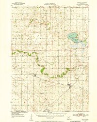 1955 Bricelyn1956 Print · USGSFaribault County agriculture and rail travel are at their peak in the mid-fifties, just north of the Iowa border. Genealogists and local historians can trace family roots through landmarks like St Marys Cem, the town of Bricelyn, and the reclaimed Oza Tanka Lakebed.
 - 1955 Map of Wells, 1956 Print
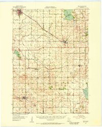 1955 Wells1956 Print · USGSSouthern Minnesota in the mid-fifties remains a world of section-line roads and busy rail junctions between Wells and Alden. Genealogists and historians can trace numerous rural schoolhouses like Pioneer Sch and local landmarks such as Zion Ch or Arrowhead Point on Freeborn Lake.
 - 1957 Map of Mason City
 1957 Mason City1957 Print · USGSThe Minnesota-Iowa border region comes alive in this mid-century survey, from the industrial plants of Mason City to the medical hub of Rochester. Researchers can trace the rail-and-river economy through the Chicago Great Western Railway and the Shell Rock River.
 - 1958 Map of Mason City
 1958 Mason City1958 Print · USGSSouthern Minnesota and northern Iowa are shown during the mid-fifties when railroads still anchored the regional economy. Genealogists and historians can trace the intricate rail networks of the Illinois Central and find local landmarks in Mason City, Albert Lea, and Austin.
 - 1958 Map of Fairmont
 1958 Fairmont1958 Print · USGSThe borderlands of southern Minnesota and northern Iowa come alive in the mid-1950s, showing a landscape defined by glacial lakes and rail-line commerce. Researchers can trace historic landmarks like Lakeside Laboratory, Gridley Station, and the Bancroft Wildlife Refuge across the prairie.
End of results
Showing maps 1-7 of 7
Top cities of Faribault County
- Blue Earth historical maps
- Wells historical maps
- Winnebago historical maps
- Elmore historical maps
- Minnesota Lake historical maps
- Kiester historical maps
See more
Frequently asked questions
- What are the different types of historical maps available for Faribault County?
- What is the oldest map of Faribault County?
- Where can I purchase historical maps of Faribault County for my home or office?
- Where can I download high-res historical maps of Faribault County?
- Are there historical topographic maps available for Faribault County?
- Is there historical aerial imagery available for Faribault County?
- Where are historical maps of Faribault County sourced from?